This objective is to strengthen and consolidate urban areas by use of infill and appropriate brownfill redevelopment to maximise the efficient use of existing infrastructure & services. ...
Chapter 2: Core Strategy and Settlement Strategy
Closed19 Feb, 2016, 10:00 - 29 Apr, 2016, 17:30
2.1 Statutory Context
The Planning and Development (Amendment) Act 2010 introduced the requirement for an evidence based ‘Core Strategy’ to be included in County Development Plans. The key purpose of core strategies is to ensure that local authorities identify and reserve an appropriate amount of land in the right locations to meet housing and population targets. This is done through the articulation of a medium to long term quantitative strategy for the spatial development of the area of the planning authority which is consistent with national and regional policy objectives set out in the National Spatial Strategy (NSS) and the Regional Planning Guidelines for the Greater Dublin Area (RPGs).
Under the Act, a Core Strategy focuses on:
- Defining a settlement hierarchy for the County that is consistent with the NSS and RPGs.
- Transposing the prescribed RPGs housing and population targets set at County level for the rural and urban centres identified within the settlement hierarchy.
- Providing an evidence based rationale for the land proposed to be zoned for residential and mixed use development having regard to the capacity of existing zoned land and the phasing of development taking account of the location of public transport and services.
- Demonstrating how the Planning Authority has had regard to the statutory Retail Planning Guidelines in setting out objectives for retail development (see Chapter 6: Economic Development).
While the Act does not expressly require core strategies to contain information concerning other land uses such as employment and commercial zones, the Guidance Note on Core Strategies, DoEHLG (2010) recommends that planning authorities undertake an appropriate level of analysis to ensure that sufficient lands are zoned at suitable locations, taking account of higher level planning policies and the required physical infrastructure.
2.2 Consistency with the National Spatial Strategy
Development Plans sit within a hierarchy of national and regional spatial plans. At the top of this hierarchy is the National Spatial Strategy. It aims to achieve a better balance of social, economic and physical development and population growth across the country. In Dublin, it favours the physical consolidation of the Metropolitan Area as an essential requirement for a competitive city region. It also seeks to sustain Dublin’s role as the engine of the national economy while strengthening the drawing power of other areas, bringing people, employment and services closer together to create a better quality of life. This will help to avoid congestion, discourage long distance commuting, enhance the environment and increase access to services like health, education and leisure. It is likely that the National Spatial Strategy will be reviewed by the Government within the next two years, coinciding with the preparation of the Fingal Development Plan 2017-2023. However, until such time as there is a replacement Strategy the Development Plan takes its policy guidance from the current NSS.
2.3 Consistency with the Regional Planning Guidelines for the GDA 2010-2022
The National Spatial Strategy was implemented in the Dublin and Mid-East Regions through the Regional Planning Guidelines for the Greater Dublin Area 2010-2022. These Guidelines continue to be the key regional policy influence on the preparation of the Development Plan. Following on from the enactment of the Local Government Reform Act 2014, three new Regional Assemblies came into effect in January 2015, replacing the previous Regional Authorities. Fingal is now part of the Eastern and Midlands Regional Assembly which is made up of the counties of Leinster less Carlow, Kilkenny and Wexford. The new Assembly will produce a Regional Spatial and Economic Strategy which will, when adopted, supersede the current RPGs. The new strategy may be produced within the two year preparation period of the Fingal Development Plan 2017-2023, and the new Plan will, insofar as is possible within the timeframe, have to be consistent with any policy changes which may occur. In the event that the new Regional Spatial and Economic Strategy is published after the adoption of the Fingal Development Plan, the Development Plan may have to go through a formal variation process to ensure that it remains consistent with any revised targets and objectives of the Regional Strategy.
Until such time as new Regional Strategies are prepared, the preparation of the Development Plan will continue to be guided by the RPGs. These Guidelines seek to deliver policies that integrate land use, transport, economic growth and investment in utilities – water, broadband and energy so that the Greater Dublin Area (GDA) can move towards becoming a sustainable high quality location for business, residents and visitors. The RPGs define the settlement hierarchy and the identification of growth areas within the GDA. Each county is assigned housing targets based on population projections up to 2022. The Fingal Development Plan is obliged to be consistent with these targets and this core strategy indicates how and where the County has sufficient zoned land to meet them.
The current RPG targets are based on the 2006 Census and are, therefore, dated. However, they indicate that while “…..in the short term, it is not planned for or expected that housing completions will be significant” and that the population targets may prove to be “…unachievable in the short-term”, it is important that “Councils are well placed for an economic recovery and that adequate provision is made, even if uptake is slower”.
2.4 Regional Planning Guidelines’ Settlement Strategy
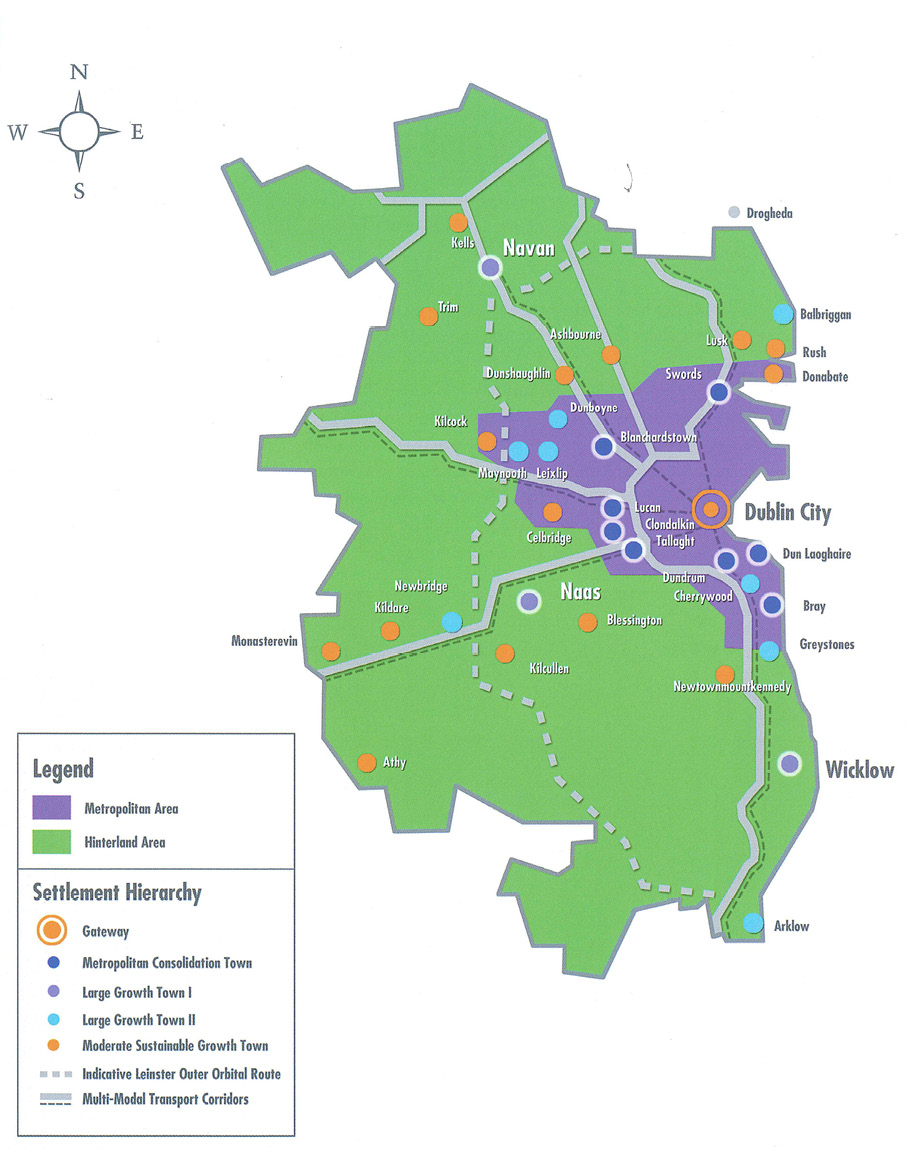
The overarching framework for Fingal’s settlement strategy is set out in the RPGs and is based on the identification of key growth areas within the Metropolitan and Hinterland Areas of the GDA (see Figure 2.3 Core Strategy Map). The stated objective of the RPGs settlement strategy is to consolidate urban areas around the Dublin Gateway and make the most efficient use of investment in infrastructure through integration with land use planning policy. The RPGs recognise that Fingal contains both a large metropolitan area and a strong rural hinterland and that new public transport corridors will provide new opportunities to strengthen the integration between high quality, high capacity public transport and housing growth.
In this regard future expansion of the existing built footprint within the metropolitan area should only happen in tandem with the planned, committed development of high quality heavy or light rail based public transport projects. This will support the implementation of the NTA’s Transport Strategy for the Greater Dublin Area and maximise the benefit of the large-scale investment currently being made in public transport in the Dublin region. The RPGs specifically recommend that the majority of future housing in Fingal should occur within the catchment areas of such strategic transport infrastructure, and phasing for towns outside of these corridors allowing for lower levels of growth in line with the natural increase in population levels. Equally, any expansion must be within carefully considered phased, high standard, integrated Local Area Plans or Strategic Development Zones where new housing and public transport and other services are delivered in tandem.
The Hinterland Area includes a varied array of urban centres from large vibrant towns to smaller locally focused villages. It also includes large areas of agricultural and natural lands as well as amenity locations within active rural communities. The value of these areas is recognised in the RPGs and it is indicated that they should be carefully managed to ensure their primary use is protected from encroachment, fragmentation and urban driven development. The identification of suitable greenbelt lands is encouraged in this regard and it is a policy approach that has been fully utilised within this Plan.
The RPG Settlement Hierarchy identifies a hierarchy of settlement types within the Metropolitan and Hinterland areas of each county and the appropriate policy for growth within them (see Table 2.1 below). Small towns and villages are defined at county level by the Development Plan (see Section 2.7, Settlement Strategy).
Table 2.1 Regional Planning Guidelines Settlement Hierarchy for the GDA
|
Hierarchy |
Description |
Locations |
|---|---|---|
|
Gateway Core |
International business core and high density population, retail & cultural activities. |
Dublin City Centre & immediate suburbs |
|
Metropolitan Consolidatio Towns |
Strong active urban places within metropolitan area with strong transport links |
Swords, Blanchardstown, Lucan, Clondalkin, Tallaght, Dundrum, Dun Laoghaire Bray. |
|
Large Growth Towns I |
Key destinations, economically active towns supporting surrounding areas, located on Multi Modal Corridor in metropolitan hinterland. |
Navan, Naas, Wicklow, Drogheda |
|
Large Growth Towns II |
Smaller in scale but strong active growth towns, economically vibrant with high quality transport links to larger towns/city |
Newbridge, Greystones, Arklow, Cherrywood, Balbriggan, Dunboyne, Maynooth, Leixlip |
|
Moderate Sustainable Growth Towns |
(i) In Metropolitan area, strong edge of metropolitan area district service centres, high quality linkages and increased densities at nodes on public transport corridors (ii) In Hinterland areas,10k from large town on public transport corridor, serve rural hinterland as market town |
Donabate, Celbridge, Lusk, Rush, Ashbourne, Dunshaughlin, Kells, Trim, Kildare, Monasterevin, Kilcullen, Kilcock, Blessington, Athy, Newtownmountkennedy. |
|
Small Towns |
Good bus or rail links; 10k from large growth towns. |
To be defined by Development Plans. |
|
Villages |
To be defined by Development Plans. |
Figure 2.1 Settlement Strategy for the GDA 2010-2022
2.5 Housing and Population Targets
Population
The RPGs translate the national and regional population targets set by the NSS to county level. Development Plans are required to be consistent with these targets albeit there is recognition that they may not be achieved within the allotted timeframe. The current RPG targets are based on data derived from the 2006 Census through the updated NSS figures produced in 2009 by the then Department of Environment, Heritage and Local Government. Targets differ from projections. CSO projections take account of mortality, fertility and migration trends but, unlike NSS/RPG targets, they do not factor in the intended influence of regional policy on population trends.
The RPG targets for the Dublin Region, the Greater Dublin Area and Fingal are set out in the tables below. Table 2.2 shows an average annual growth rate of 1.47% targeted for the Dublin Region between 2006 and 2022 and 1.7% for the GDA. Actual average growth per annum from 2006 to 2011 was as targeted. CSO population estimates from 2015, included in Table 2.2, suggest a slowdown in the annual growth in the Dublin Region since 2011 to 0.63% per annum and 0.95% per annum in the Mid-East.
Table 2.2 RPG Targets for the Dublin Region and GDA
|
Census 2006 |
RPG 2010 |
Census 2011 |
Preliminary CSO Estimates 2015 [1] |
RPG Target 2016 |
RPG Target 2022 |
|
|---|---|---|---|---|---|---|
|
Dublin Region |
1,187,176 |
1,256,900 |
1,273,069 |
1,305,300 |
1,361,200 |
1,464,200 |
|
GDA |
1,662,536 |
1,796,900 |
1,804,156 |
1,856,700 |
1,955,800 |
2,103,900 |
The RPG population targets for Fingal in Table 2.3 represent an increase of 13,555 persons on 2011 levels by 2016 and an increase of 35,293 persons by 2022. This is an annual growth rate of 1% per annum 2011-2016 and 1.17% per annum over the years 2011-2022. This would represent a faster rate of growth than the 0.63% CSO 2015 estimates for the region, but it would be a significant slowdown on the rates of growth experienced by Fingal over the period 2002 to 2006 and 2006 to 2011 when the County grew by almost 5.55% and 2.84% per annum over each period respectively.
Table 2.3 Actual and RPG Population and Housing Targets for Fingal
|
Fingal |
Census 2006 |
Census 2011 |
RPG Target 2016 |
RPG Target 2022 |
RPG Target 2023 (estimated) |
|---|---|---|---|---|---|
|
Population |
239,992 |
273,992 |
287,547 |
309,285 |
312,908 |
Housing
Fingal’s share of Dublin’s housing stock rose from 18.8% in 2006 to 19.5% in 2011. The RPGs have targeted a share for Fingal of 19.8% of Dublin housing for the years 2016 and 2022 respectively.
Table 2.4 Actual and RPG Population and Housing Targets for Fingal
|
Fingal |
Census 2006 |
Census 2011 |
RPG Target 2016 |
RPG Target 2022 |
Estimated RPG Target 2023 |
|---|---|---|---|---|---|
|
Population |
239,992 |
273,992 |
287,547 |
309,285 |
|
|
Housing Stock |
89,909 |
102,793 |
118,646 |
142,144 |
145,340 |
|
Persons per hhd* |
2.66 |
2.66 |
2.42 |
2.17 |
- * Note comments within main text, the occupancy rate is closer to 2.9 for recent Census years.
An increase of 15,853 units in Fingal is required to meet the 2016 RPG targets from the 2011 level. This represents an annual requirement for 3,170 units. Between 2011 and 2022 a total of 39,351 units were targeted representing 3,577 units per annum. In normal market conditions the lower figure per annum would not be an unreasonable target for Fingal.
Figure 2.2: Residential Completions in Fingal 1994-2014
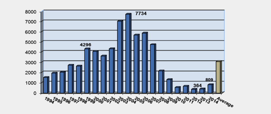
However, under recent market conditions DECLG completion figures indicate a total of 2,599 units completed in Fingal between the Census in April 2011 and July 2015 (the most recent completion figures available), indicating an average of 650 units per annum. This gives an estimated housing stock in Fingal in mid-2015 of 105,392 units. Based on current housing stock, 5,700 units per annum over the 7 year period 2016 to 2023 would be necessary to fulfil RPG targets. Table 2.5 sets out the housing growth required to meet the RPG targets. In reality, this is an unsustainable target. Research done on behalf of the Housing Agency in 2014 indicated that an average annual production of c.7,500 units is required in the Dublin Region’s urban settlements between 2014-2018 [2]. If Fingal took 20% of this growth, to align with its RPG target share, completions would need to be in the order of 1,500 units per annum.
Table 2.5 Number of New Residential Units in Fingal required to meet RPG Targets
|
Estimated Existing Units July 2015 |
RPG Target Unit 2022 |
RPG Target Unit 202 (estimated) |
New Unit Targe 2016-2023 |
Headroom Requiremen 2023-2026 |
New Unit Targe 2016-2026 |
|---|---|---|---|---|---|
|
105,392 |
142,144 |
145,340 |
39,948 |
9,588 |
49,536 |
Dealing with Uncertainty
The Development Plan is being reviewed at a time when there is a vacuum in population data and associated targets. Recent CSO figures indicate that the population of the Dublin Region has not grown to the extent targeted by the RPGs. This is perhaps to be expected given the level of emigration witnessed since 2007. However, the figures set out in the earlier paragraphs suggest that Fingal may be an exception within the Dublin Region. If Fingal maintains its 2011 share of Dublin’s population then by 2016 it will be very close to the RPG population targets. If it were to increase its share, which it may do given the young demographics, it could even exceed the population targets.
The difficulty for Fingal is in anticipating the housing need associated with the growing population. Unlike the population targets, it is very clear that the RPG housing targets will not be met in the short term. While the delivery of new housing is a priority, if recent population growth is primarily associated with growing family sizes there may not be an immediate requirement to grow the housing stock proportionately. The most important priority for Fingal is to ensure that there is sufficient land zoned in the right places to meet the housing targets up to 2023 in the first instance, recognising that much of this may not be completed until after that date. This will involve consolidating urban areas around the Dublin Gateway and making the most efficient use of investment in infrastructure through integration with land use planning policy.
While it is important to ensure that sufficient land is zoned, Fingal must have cognisance of the fact that current regional policy does not provide for any significant growth of the County’s share of the Dublin Region’s population or housing stock. Planning policy remains one of consolidation within the metropolitan area with expansion only happening in tandem with the planned, committed development of high quality heavy or light rail based public transport projects. Until such time as the new Regional Spatial and Economic Strategies are produced by the Regional Assemblies it would be imprudent for Fingal to assume changes in established regional policy.
2.6 Housing Land Capacity under the 2011-2017 Development Plan
In mid-2015 there are approx. 1,461ha of zoned land available with the potential to deliver approx. 43,041 residential units (see Table 2.6 below). This includes the villages and also incorporates the potential for small sustainable infill development. This is in excess of the target of 39,948 units for the Development Plan period 2017-2023. However, it is approximately 6,000 units short of the estimated RPG target, including the 50% headroom up to 2026, of 49,536. The distribution of Fingal’s remaining housing capacity on zoned residential/mixed use land in the 2011-2017 Development Plan is set out in Table 2.6.
Table 2.6 Remaining Zoned Residential Capacity from Fingal Development Plan 2011-2017
|
Town/Village |
Remaining Land Supply (hectares) |
Remaining Capacity Residential Units |
Metropolitan-Hinterland % Land |
Metropolitan-Hinterland % Units |
|---|---|---|---|---|
|
Metropolitan Area |
||||
|
Consolidation Towns |
||||
|
Swords |
293 |
9,328 |
||
|
Blanchardstown |
320 |
11,757 |
||
|
Consolidation Areas within the Gateway |
||||
|
Malahide |
88 |
1114 |
||
|
Portmarnock |
57 |
1490 |
||
|
Howth |
16 |
498 |
||
|
Baldoyle/Sutton |
29 |
1498 |
||
|
Other Settlements* |
71 |
2791 |
||
|
Moderate Sustainable Growth Town |
||||
|
Donabate |
116 |
4056 |
||
|
Small Towns/Villages |
94 |
877 |
||
|
Total Metropolitan |
1,084 |
33,409 |
74% |
78% |
|
Hinterland Area |
||||
|
Large Growth Town II |
||||
|
Balbriggan |
153 |
4332 |
||
|
Moderate Sustainable Growth Towns & Other |
||||
|
Rush |
58 |
1994 |
||
|
Lusk |
43 |
1218 |
||
|
Skerries |
41 |
1175 |
||
|
Small Towns & Villages |
82 |
913 |
||
|
Total Hinterland |
377 |
9,632 |
26% |
22% |
|
TOTAL Fingal** |
1,461 |
43,041 |
100 |
100 |
- * This includes Charlestown & Meakstown, Santry & Ballymun, Balgriffin &Belcamp, Baskin and part of Kinsaley.
- ** The total number of units does not include permissions for rural ‘one-off’s’ or rural clusters.
New Residential Zoning
The emphasis of this Plan is to continue to consolidate the existing zoned lands and to maximise the efficient use of existing and proposed infrastructure. In this way the Council can ensure an integrated land use and transport strategy in line with national and regional policy. It will also ensure that the Council is in a strong position to influence infrastructure providers at national level, including Irish Water, in that there will be clear evidence of the Council’s commitment to maximising investment in infrastructure through its policy of consolidation. The development of larger areas of residential or mixed use lands will only take place subject to the necessary infrastructure being available and to this end will be subject to a Local Area Plan. It is through the LAP process that, within the towns and villages, the detailed phasing and distribution of housing will be determined in line with the population and housing targets established at a strategic level.
Fingal has a significant quantum of land zoned to achieve the RPG targets. However, to be ready for any increased uptake and to account for constraints on some of the existing zoned lands, it is proposed to zone a strategic land bank at Lissenhall. This will ensure that Fingal is well placed to meet housing demand in a phased manner and to maximise the efficiencies of State investment in existing and proposed public transport infrastructure. This new zoning is located in the Metropolitan Area, ensuring that any further negative deviation from the RPG targets does not occur.
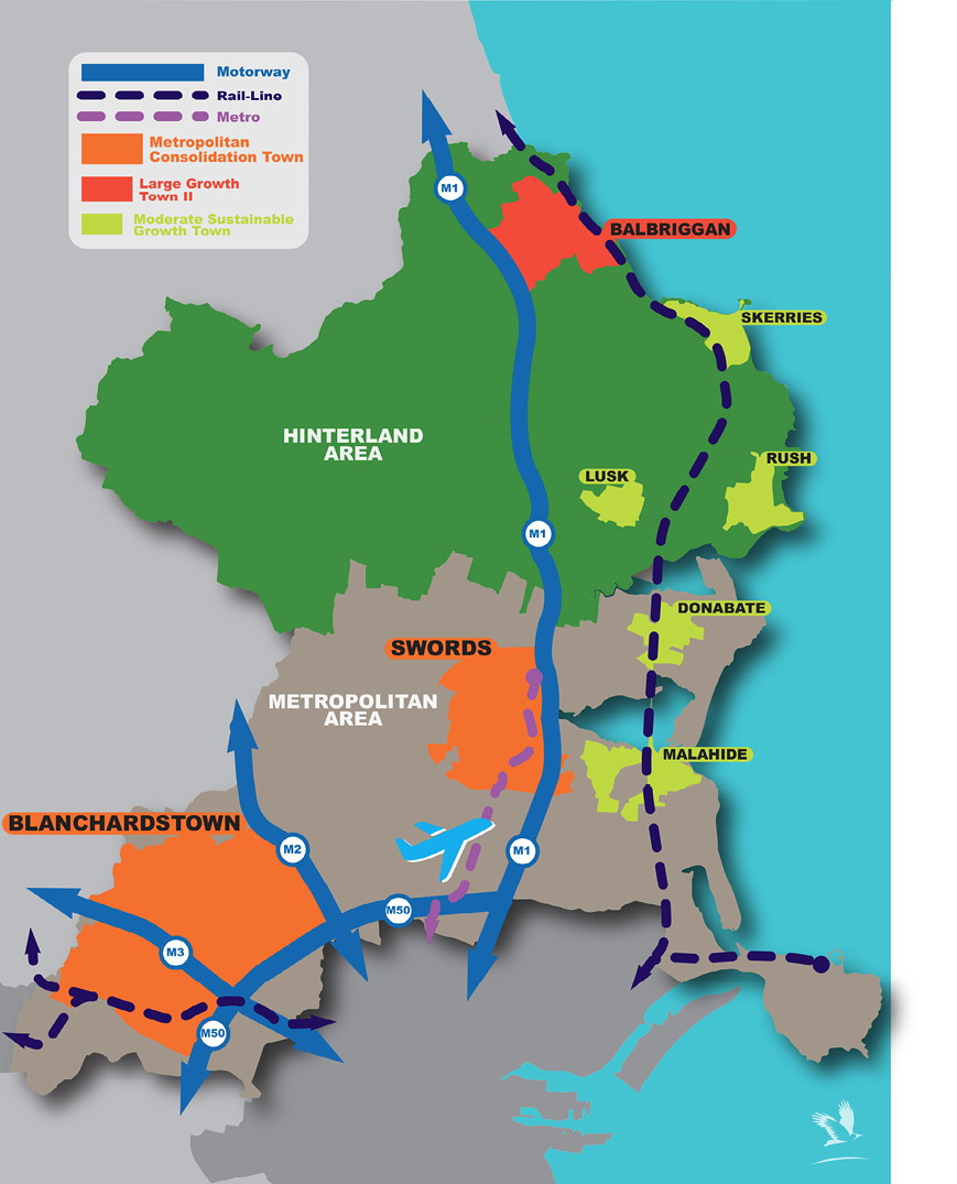
Lissenhall, Swords
In anticipation of the development of the proposed new Metro North, a strategic land bank providing for the development of a sustainable, vibrant, attractive and well-connected mixed use urban district on the northern side of Swords has been identified at Lissenhall. These lands would be the subject of an approved Local Area Plan and be developed over the period of several Development Plans i.e. over the next 20 – 25 years.
Swords is the County administrative and capital of the County. The town has direct links to the national road network (M1 and M50) and is located on the Dublin/Belfast economic corridor which is a key national transport corridor in the NSS. Swords is located adjacent to the key gateways of Dublin Port, via Dublin Port Tunnel, and Dublin Airport, two important gateways to the Country. With the announcement of the proposed new Metro North Swords will be extremely well connected to Dublin City’s economic and commercial life and even more so to Dublin Airport. This will stimulate significant economic growth and expansion of the area bringing with it a range of challenges which include:
- Provision of new sustainable housing
- Provision of facilities for community, educational, health and recreational needs
- Increased number and range of employment activities
- Provision of high quality open spaces and landscape
- Connectivity and accessibility to all the above for new and existing communities
- Ensuring high standards in architecture and urban design
The proposed new Metro North will facilitate the optimal development of Swords into the future and the Council will maximise the benefits of and the efficient use of the Metro for the benefit of those living and working in the town. The Council, in accordance with best practice and the principles of sustainable development, will seek to maximize the opportunities created by the arrival of this key piece of infrastructure. To this end the identification and promotion of Metro Economic Corridor(s) will be of strategic importance to the economy and well-being of the County’s residential and business/employment population.
The long term strategic vision for Swords is to create a sustainable city with a commensurate level of jobs and services and infrastructure to support a potential population of 100,000. In endeavouring to achieve this vision of an emerging green city with a thriving economy it is critical that adequate lands are zoned in the future to accommodate the full range of needs of the city’s residential population, business community and visitors. Within the current development envelope of Swords, even allowing for the introduction of possible new intensive mixed use zonings along the Metro line, Swords would have the capacity only to reach a population of circa 65-70,000.
There is potential for the proposed new Metro North to extend into the lands at Lissenhall and therefore, the zoning must be appropriate for the area. Furthermore, a substantial portion of these lands will be within 1km of the agreed Estuary Stop. Lissenhall is an expansive, low-lying, rural landscape comprising approximately 240 hectares. The area, in broad terms, is bound by the M1 and R132 to the east, the Broadmeadow River to the south and south west, and the proposed route of the Swords Western Ring Road to the north. These lands are adjacent to the M1 and Belfast-Dublin corridor.
By identifying Lissenhall as a key future development area, the Council is seeking to maximize the opportunities created by the delivery of this key piece of strategic infrastructure in accordance with best planning practice and the principles of sustainable development. The development of the area is also consistent with the Council’s long term strategic vision for Swords to develop as a sustainable city. It is envisaged that this area could accommodate the development of a significant mixed use urban district providing for a significant level of employment in addition to approximately 6,000 – 7,000 residential units. A Local Area Plan will be prepared for these lands to provide a framework for development. Lissenhall is detailed further in Chapter 4 Urban Fingal, in the context of Swords.
Table 2.7 below outlines the potential capacity at Lissenhall.
Table 2.7 Proposed New Residential and Mixed Use Zoning 2017-2023
|
Metropolitan Area |
New Mixed Use (ha) |
Total New (ha) |
Net Potential New Units |
|
|---|---|---|---|---|
|
ME |
MC/TC/LC/RV |
|||
|
Swords - Lissenhall |
221 |
221 |
6,000 – 7,000 |
|
Total Capacity - Fingal Development Plan 2017 – 2023
Table 2.8 below sets out the total land and housing capacity for the 2017-2023 Development Plan. This is essentially the sum of Table 2.6 which outlines the capacity of existing zoned lands and Table 2.7 which indicates the potential of lands proposed to be zoned.
Table 2.8 Total Residential Capacity provided under the Fingal Development Plan 2017-2023
|
Town/Village |
Land Supply (hectares) |
Potential Residential Units |
|---|---|---|
|
Metropolitan Area |
||
|
Consolidation Towns |
||
|
Swords |
514 |
15,828 |
|
Blanchardstown |
320 |
11,757 |
|
Consolidation Areas within the Gateway |
||
|
Malahide |
88 |
1114 |
|
Portmarnock |
57 |
1490 |
|
Howth |
16 |
498 |
|
Baldoyle/Sutton |
29 |
1498 |
|
Other Settlements* |
71 |
2791 |
|
Moderate Sustainable Growth Town |
||
|
Donabate |
116 |
4056 |
|
Small Towns/Villages |
94 |
877 |
|
Total Metropolitan |
1,305 |
39,909 (81% of total) |
|
Hinterland Area |
||
|
Large Growth Town II |
||
|
Balbriggan |
153 |
4332 |
|
Moderate Sustainable Growth Towns & Other |
||
|
Rush |
58 |
1994 |
|
Lusk |
43 |
1218 |
|
Skerries |
41 |
1175 |
|
Small Towns & Villages |
82 |
913 |
|
Total Hinterland |
377 |
9,632 (19% of total) |
|
TOTAL Fingal** |
1,682 |
49,541 |
- * This includes Charlestown & Meakstown, Santry & Ballymun, Balgriffin &Belcamp, Baskin and part of Kinsaley.
- ** The total number of units does not include permissions for rural ‘one-off’s’ or rural clusters.
While Table 2.8 outlines the potential to deliver 49,541 units, it must be interpreted in the County Fingal context, in that the land will become available on a phased basis. The key tenet of the overall Settlement Strategy is the continued promotion of sustainable development through positively encouraging consolidation and densification of the existing urban built form – and thereby maximising efficiencies from already established physical and social infrastructure.
Therefore this level of development is unlikely to be developed over the lifetime of this County Development Plan (6 years unless amended by legislation) rather it outlines the optimal sustainable development strategy for the County over a longer time period and can only be developed in tandem with the timely delivery of the necessary physical infrastructure.
It is also noted that the housing capacity allocated to Hansfield SDZ could be excluded from the total figures, as per the DoEHLG guidance notes. Having regard to the DoEHLG Guidance Notes on Core Strategies issued in November 2010, the DoEHLG suggest that ‘any excess (of lands or housing capacity) will not normally include lands identified for the strategic long term development as part of Strategic Development Zones or major regeneration sites within key areas…’. Notwithstanding this, in order to identify the full potential of zoned lands within the County these figures have been included in Tables 2.5 and 2.7.
The development of the strategic lands at Lissenhall will be subject to a Local Area Plan, SEA and Appropriate Assessment and will also be dependent on the concurrent delivery of adequate water services and upgraded /planned public transport infrastructure.
In relation to the development of other lands within the County, Local Area Plans, the SDZ at Hansfield, and Masterplans, will establish more detailed phasing or prioritisation for the delivery of residential uses, other uses, or infrastructure, as appropriate. Such locally-based plans and related requirements are set out in Chapter 4, Urban Fingal.
2.7 Settlement Strategy
The Fingal settlement strategy embraces the strategic approach advocated by the Regional Planning Guidelines to physically consolidate the majority of future growth into the strong and dynamic urban centres of the metropolitan area while directing development in the hinterland to towns and villages in order to discourage dispersed development and unsustainable travel patterns. To achieve this objective sufficient lands have been zoned to accommodate anticipated population growth through a mix of varied house types and sizes in areas with good public transport links. This approach has been balanced by the countervailing need to avoid an oversupply that would lead to fragmented development, uneconomic infrastructure provision and urban sprawl.
At its core, the Plan envisages that the future development and growth of Fingal will take place in accordance with an overarching hierarchy of settlement centres. Each identified settlement centre will accommodate an agreed quantum of future development appropriate to its respective position in the hierarchy.
Table 2.9 Fingal Settlement Strategy 2011-2017
|
Metropolitan Area |
Hinterland Area |
|---|---|
|
Metropolitan Consolidation Towns Swords Blanchardstown |
Large Growth Town – Level II Balbriggan |
|
Consolidation Areas Within Gateway Baldoyle Castleknock Clonsilla Howth Baskin Mulhuddart Village Portmarnock Sutton Santry (Incl. Ballymun) Balgriffin & Belcamp Charlestown & Meakstown |
Moderate Sustainable Growth & Other Towns Lusk Rush Skerries |
|
Other Hinterland Towns/Villages Balrothery Loughshinny |
|
|
Moderate Sustainable Growth Towns Donabate Malahide |
Villages Ballyboghil Naul Balscadden Oldtown Garristown |
|
Small Town Portrane |
|
|
Villages Coolquay Kinsealy Rivermeade Rowlestown |
|
|
Rural Clusters See chapter 5 entitled ‘Rural Fingal’ for a full list of rural clusters |
|
Consolidate the vast majority of the county’s future growth into the strong and dynamic urban centres of the metropolitan area while directing development in the hinterland to towns and villages, as advocated by national and regional planning guidance.
Ensure that all proposals for residential development accord with the county’s settlement strategy and are consistent with Fingal’s identified hierarchy of settlement centres.
Identify sufficient lands for residential development in order to achieve the housing and population targets set out in the Core Strategy, while ensuring that excess lands surplus to this specific requirement are not identified, in order to prevent fragmented development, uneconomic infrastructure provision and car dependent urban sprawl.
Figure 2.3 Core Strategy Map
Rural Settlement
The strategy is also cognisant of the need to support rural communities and ensure they remain vibrant and self-sustaining through the facilitation of genuine rural generated housing need in a manner which is consistent with Fingal’s classification as “an area under strong urban influence”, while also balancing the need to minimise encroachment upon viable agricultural lands. This will primarily be achieved through the orderly development of identified rural villages and clusters, recognising the distinction between villages in the metropolitan area and those in the rural hinterland. The Council will also promote the re-use and rehabilitation of existing housing stock in rural areas in preference to new build in order to preserve and enhance the distinct character of rural Fingal. Detailed policy governing rural development is contained in Chapter 5 ‘Rural Fingal’.
Direct rural generated housing demand to villages and rural clusters in the first instance and to ensure that individual houses in the open countryside are only permitted where the applicant can demonstrate compliance with the criteria for rural housing set down by this Development Plan.
Greenbelts
The targeted development of strategically identified towns and villages will be supported by a greenbelt policy which will safeguard the innate rural value of the Fingal countryside. Greenbelt zoning will underpin the settlement strategy by ensuring:
- Existing urban areas within Fingal do not coalesce and merge into one another leading to unsustainable development and travel patterns.
- The identity and unique character of rural and urban areas in the vicinity of administrative boundaries will be maintained where this would be beneficial.
- That citizens can enjoy the visual and natural amenities of the countryside in close proximity to the urban areas in which they reside.
- Proposed development within the Greenbelt shall clearly demonstrate a functional need for such a location, and consistency with the established character of the landscape of the area.
Strengthen greenbelt lands by identifying opportunities for infill development and consolidation of existing towns to reduce the need to zone additional greenfield lands and ensure the preservation of strategic greenbelts between our towns and villages.
Promote development within the Greenbelts which has a demonstrated need for such a location, and which protects and promotes the permanency of the Greenbelt, and the open and rural character of the area.
Promote public parks, outdoor sports facilities and other recreational uses within the Greenbelts in accordance with the Green Infrastructure Strategy and open space policy.
2.8 Settlement Strategy for the Metropolitan Area
Metropolitan Consolidation Towns
Swords and Blanchardstown are the largest urban centres in Fingal and are classed as Metropolitan Consolidation Towns in the Regional Planning Guidelines. The towns function as part of the Dublin Gateway as identified by the National Spatial Strategy and will continue to perform the role of the county’s primary development centres during the plan period. As identified key locations for housing, enterprise and retail development, the long term population horizon envisaged in the Regional Planning Guidelines for each of these centres is c.100,000 people. The proposed development of Lissenhall (Swords) is consistent with this strategy and reinforces the strategic role of Swords in the settlement hierarchy.
Swords, Fingal’s county town, is identified as a Level 2 ‘Major Town Centre’ in the Retail Strategy for the Greater Dublin Area and has a well-developed retail offering which includes the Pavilions Shopping Centre and Airside Retail Park. The town also benefits from its close proximity to Dublin Airport and has a strong industrial base which underpins its role as an important centre for employment in the county. One of Swords key strengths is the quality of road infrastructure serving the town. Direct access to the M1 motorway on the Dublin-Belfast economic corridor is complemented by a high quality regional road network (R125 & R132 dual carriageways). The NTA and TII are also currently progressing plans to develop the proposed new Metro North to serve the town. A masterplan for the long term development of Swords was published by the Council in January 2009 and remains a relevant guidance document for the future development of the area.
Blanchardstown, strategically located at the intersection of the N3 and M50 national roads, is the largest settlement centre in Fingal. Designated as a Level 2 ‘Major Town Centre’ in the Retail Strategy for the Greater Dublin Area, it is also one of the largest and most important retail centres in the State. In addition to Blanchardstown Town Centre, a number of large public sector employers are based in the area including Fingal County Council, Connolly Hospital and the Institute of Technology (ITB). The IDA has also been particularly successful in marketing Blanchardstown as a key location for foreign direct investment and a number of large ICT and pharmaceutical companies have long established operations in the area. The state of the art National Sports Campus is located nearby at Abbottstown. Lands at Hansfield are designated as a Strategic Development Zone (SDZ) and this planned new sustainable community will be served by rail via the newly constructed railway station at Hansfield on the Clonsilla to M3 Parkway railway spur.
The strategic location and development potential of lands at Dunsink is recognised within this Development Plan. This land area comprises 125 hectares and forms part of the townlands of Ashtown, Castleknock, Dunsink and Scribblestown. The lands are characterised by their current use for predominantly agricultural and recreational amenity purposes. The Royal Canal and Tolka River Valley run to the south of the lands while Elm Green Golf Course covers a large part of the western portion of the site. Located only six kilometres from Dublin City Centre, this area provides a unique opportunity to significantly consolidate the Dublin Gateway in a sustainable manner underpinned by high quality public transport given the site benefits from close proximity to the existing heavy rail network at Ashtown and the proposed extension to the Luas to Finglas. In addition, commercial development would benefit from access to the nearby M50 motorway. It is envisaged that the lands could facilitate approximately 4,000 – 5,000 residential units. While recognising these lands as a potential strategic landbank for the County, it is acknowledged that the current infrastructural constraints on these lands require further detailed investigation that should inform any future decision to zone these lands for a mixed use urban district. Any future development of these lands would also be the subject of an approved Local Area Plan. In this regard, an Objective is included in Chapter 4, Urban Fingal to carry out a comprehensive Strategic Study for the lands at Dunsink within the lifetime of the Development Plan that will identify the necessary physical infrastructure required to realise the full development potential of these lands.
Promote the Metropolitan Consolidation Towns of Swords and Blanchardstown as Fingal’s primary growth centres for residential development in line with the County’s Settlement Hierarchy.
Facilitate the provision of sufficient employment, retail, community and cultural facilities to serve the growing residential communities of Swords and Blanchardstown.
Consolidation Areas within the Gateway
There are a number of settlements across the county which have their own distinct character and sense of place but given their location in close proximity to Dublin City, respectively form consolidation areas within the gateway. These areas include Baldoyle, Castleknock, Clonsilla, Howth, Mulhuddart, Portmarnock, Sutton, and parts of the city suburbs located close to the M50 motorway.
The policy approach in these areas will be to gain maximum benefit from existing transport, social, and community infrastructure through the continued consolidation of the city and its suburbs. Future development will happen in a planned and efficient manner utilising opportunities to achieve increased densities where appropriate.
Strengthen and consolidate existing urban areas adjoining Dublin City through infill and appropriate brownfield redevelopment in order to maximise the efficient use of existing infrastructure and services.
Moderate Sustainable Growth Towns
In the metropolitan area, Moderate Sustainable Growth Towns are positioned at the sub-county town level in the settlement hierarchy where economic activity is well developed but not typically of a sufficiently robust level to wholly sustain the local population. For this reason commuting by public transport and private car to higher order centres is a common characteristic of these towns.
As Moderate Sustainable Growth Towns, Donabate and Malahide will continue to play an important role within a consolidated metropolitan area. Development in these towns should be linked to the capacity of high quality public transport connections and the provision of social and community infrastructure such as schools and leisure facilities.
Small Towns
Small towns are centres of between 1500 and 5000 people, characterised by small local businesses and modest retail provision mainly in the convenience category. Development in these centres is to be managed in line with the ability of local services and infrastructure to accommodate expansion, having regard to the recommendations for small towns included in the Ministerial Guidelines on Sustainable Residential Development in Urban Areas and the Regional Planning Guidelines for the Greater Dublin Area.
Portrane is Fingal’s only ‘Small Town’ and is noteworthy for both its natural and architectural heritage. It is composed of three distinct areas: Portrane Village, The Burrow and St. Ita’s Hospital. Any development proposed in these areas will have to demonstrate sensitivity to this high value setting.
Villages
There are four villages in the metropolitan area. These complement and support higher order settlement centres located on the edge of the gateway.
The future development of Fingal’s villages needs careful consideration. In the metropolitan area growth in villages such as Coolquay, Kinsealy, Rivermeade and Rowlestown will be managed to ensure these centres do not expand rapidly, putting pressure on services and the environment and creating the potential for unsustainable travel patterns. Objectives for the development of villages are set out in Chapter 5, Rural Fingal.
Rural Clusters
The Rural Clusters serve as areas where members of the rural community can live as an alternative to housing in the open countryside. There are eight such clusters in the metropolitan area. Further information on rural clusters is contained within Chapter 5, Rural Fingal.
2.9 Settlement Strategy for the Hinterland Area
Large Growth Town – Level II
Large Growth Towns serve as significant hubs for residential development and economic activity of both a commercial and industrial nature. They act as important self-sustaining regional economic drivers benefitting from high quality connections to Dublin City Centre.
Balbriggan is Fingal’s only Large Growth Town and it is the largest urban centre within the hinterland area. It is characterised by a young and expanding population which has rapidly grown to in excess of 20,000 people over the last two decades. Major investment by Fingal County Council and other stakeholders in the town’s water services and roads infrastructure has provided a basis for the town to continue to grow in a sustainable manner.
Balbriggan has a substantial quantum of zoned land for high technology and general industrial development. The town’s excellent accessibility to major transport corridors, as well as its proximity to Dublin Airport and the Ports at Drogheda and Dublin make Balbriggan a desirable location for enterprise.
Moderate Sustainable Growth Towns and Other Towns
In the hinterland area, the towns of Lusk, Rush and Skerries rely on the provision of quality local services and also serve as commercial nodes for their immediate rural environs as their location is more remote from higher order centres. Skerries was not categorised in the settlement strategy of the Regional Planning Guidelines but it best fits with the description of being a Moderate Sustainable Growth Town given its substantial population, vibrant town centre and varied retail offer.
It will be important that Lusk, Rush and Skerries develop in a self-sufficient manner in order to prevent them from becoming dormitory towns. A full range of services should be available to meet local needs and that of the surrounding rural areas in order to encourage smarter travel patterns and to provide for further growth. At present Skerries has the most developed commercial offering of the three towns, while Rush has benefitted from recent investment. It will be a priority to supplement the retail and local services offering in Lusk in order to provide for population growth in the town.
Other Hinterland Towns/Villages
Balrothery and Loughshinny are different from the other villages in the county as both centres have been specifically identified for a limited level of additional housing development and have the necessary residential zoning in place to facilitate this.
Balrothery is an historic village located to the south of Balbriggan. While there has been extensive residential development over the past number of years, the historic core of the village, which is a designated Architectural Conservation Area (ACA), has been maintained and has positively influenced more recent development. The footprint of the village is naturally contained by a combination of the surrounding amenity land uses and identified greenbelt lands.
Loughshinny is an attractive coastal village characterised by its traditional seaside vernacular buildings as well as its harbour. The landscape context is highly sensitive and rich in both archaeological and natural heritage. Any new development must be proposed at a scale that is both appropriate to the size of the village and respectful of its unique character.
Rural Villages
There are five villages located in the hinterland area. These act as rural service centres which meet the basic everyday needs of each village and its immediate rural environs.
The development of Ballyboghil, Balscadden, Garristown, Naul and Oldtown will be guided by their village function as key centres for local services and rural enterprise. Objectives for the development of villages are set out in Chapter 5, Rural Fingal.
Rural Clusters
There are twenty six rural clusters located in the hinterland area. These small settlements will play an important role in accommodating rural generated housing need in the county by helping to contain pressure for housing in the open countryside. Further information on rural clusters is provides in the Chapter 5, Rural Fingal.
2.10 Housing Strategy
Social housing and homelessness are amongst the greatest challenges to be addressed by the Council in the current plan period. Fingal County Council’s Housing Department manages social housing provision and the Local Authority’s response to homelessness through a number of initiatives. Detailed information can be found in the Housing Strategy (Appendix 1) of the plan.
Contents
Materials
References
Observations
Observations
Proper planning of new Residential estates
Residential developments in Balbriggan have made the town very disjointed and have affected people greatly due to the quality of building where pyrite damage and large developments have left...
Equitable Distribution of Social Housing
Social housing is needed in society. However, towns like Balbriggan, have seen an over-allocation of social housing especially in comparison to many of the more affluent areas in Fingal, where...
Scribblestown Strategic Residential Development Land Resource
7.1 Changes Sought to Draft Fingal County Development Plan 2017-2023
We respectfully seek the following amendments to the Draft...
Zoned land within Metro Economic Corridor
See submission attached, as prepared by Hughes Planning and Development Consultants.
The purpose of this submission is:
To acknowledge and support Council’s proposal to rezone part of...