Dublin 15 is one of most diverse area in state, it is apparent that there is a significant unaddressed need for diverse places of worship that enables each faith community access to a place of...
Chapter 12: Development management standards
Closed19 Feb, 2016, 10:00 - 29 Apr, 2016, 17:30
12.1 Background
Development Management is one of the main implementation tools of the Draft Development Plan. This Chapter sets out the development standards and criteria to ensure development occurs in an orderly and efficient manner. In all development proposals, it is the aim of the Planning Authority to promote a high standard of design and amenity and to complement the existing character of a particular area. Proposals must comply with the standards and criteria that apply to particular development types, be consistent with the objectives set out in the preceding Chapters and be compliant with relevant legislative guidance.

Pre-Planning
Section 247 of the Planning and Development Act 2000 (as amended) provides a formal procedure for applicants to seek pre-planning guidance from the Planning Authority in relation to their proposed development. The Planning Authority provides pre-application consultations where requested and actively encourages such consultations prior to the lodging of a planning application.
Enforcement
Development will be controlled in accordance with policies and objectives set out in the County Development Plan and in accordance with the principles of proper planning and sustainable development. With regard to the enforcement provisions of Part VIII of the Planning and Development Act 2000, as amended, the role of the Planning Authority is to undertake enforcement action where necessary with respect to non-compliance with conditions attached to planning permissions and the carrying out of non exempted development without the benefit of planning permission. Furthermore the planning authority has special control powers under current legislation pertaining to such areas as protected structures and tree preservation orders. In addition, the Planning Authority will continue the practice of granting planning permission with the inclusion of conditions requiring levies and/or bonds to be paid to ensure compliance with the conditions of the permission. The provisions of Section 35 of the Act may be evoked where appropriate.
12.2 Common Principles for All Planning Applications
All development schemes shall promote the principles of accessibility, green infrastructure and sustainable design together with best practice in architectural design and conservation.
Access for All
The Council recognises the need for universal equality of access to all aspects of the built and external environment as an essential prerequisite of equal opportunity and the development of an inclusive society. Part M of the Building Regulations sets out standards to ensure that buildings are accessible to and usable by everyone, including older people, people with disabilities and people with children. The Technical Guidance Document in relation to Part M provides guidance on the access requirements for public buildings and for residential dwellings.
The Council will seek to encourage the implementation of best practice standards with regard to access in both indoor and outdoor environments. In assessing planning applications, which relate to protected structures, regard shall be had to the protected status of the structure and the need to protect the special character. An important element in achieving sustainability in the design of residential units is the ability of the design to accommodate the changing needs of a family. Housing with long term adaptability and potential for flexibility allows for change as circumstances alter or families grow. Adaptability that allows for the alteration of the fabric of a building and flexibility which allows for spaces to accommodate a range of uses, are key considerations in the design of a home. The guiding principle of accessibility shall be clearly demonstrated in development proposals.
Green Infrastructure
Existing green infrastructure should be identified at the initial stages of the planning process for development and should guide the design of an appropriate site layout. A landscaping plan shall be submitted with an application that clearly illustrates how existing green infrastructure and opportunities to create new natural amenities, open space and linkages have informed and are incorporated into development management layout and proposals.
Sustainable Design
Layout and building design must conform to the highest possible standards of energy efficiency. Buildings shall be designed to minimise resource consumption, reducing waste, water and energy use. Design shall optimise natural ventilation and minimise glare and excess solar gain, avoiding large areas of glazing and providing an appropriate balance between solid and void elements.
Energy-saving and energy generating technologies, such as roof top solar panels and geothermal energy, shall be incorporated at the design stage where possible. Sustainably sourced materials and existing re-used/recycled materials shall also be used where possible. Measures which will allow occupants to adapt to the impacts of climate change are promoted within developments and include natural ventilation, summer shading, openable windows, the incorporation of living roofs and walls, planting and trees, as well as the inclusion of sustainable urban drainage systems (SuDs) and permeable surfaces in adjoining spaces. Design shall optimise natural ventilation, minimise overshadowing, minimise glare and excessive solar gain. Measures to mitigate and adapt to the impacts of climate change shall be appropriate to the special and architectural character of an area.
These sustainable design elements shall be considered from the outset of the design process as they are integral to density, building orientation, height, form and materials and overall aesthetics and functionality of a proposed scheme.
Assessments Required for Particular Projects
Environmental Impact Assessment
The Planning and Development Regulations 2001 specify mandatory thresholds above which Environmental Impact Statements (EIS) are required in relation to types and scale of development proposals. Where it appears to the Planning Authority that a development proposal would be
likely to have significant effects on the environment, a ‘sub threshold/discretionary EIS’ can be requested by notice in writing.
Screening for Appropriate Assessment
Under Article 6 of the Habitats Directive there is a requirement to establish whether, in relation to plans and projects, if Appropriate Assessment (AA) is required. If, following screening, it is considered that AA is required, the proponent of the plan or project must prepare a Natura Impact Statement. A plan or project will only be authorised after the competent authority has ascertained, based on scientific evidence, Screening for Appropriate Assessment, and a Stage 2
Appropriate Assessment where necessary, that:
- The plan or project will not give rise to significant adverse direct, indirect or secondary effects on the integrity of any European (Natura 2000) site (s) (either individually or in combination with other plans or projects); or
- The plan or project will have significant adverse effects on the integrity of any European (Natura 2000) site(s) (that does not host a priority natural habitat type and/or a priority species) but there are no alternative solutions and the plan or project must nevertheless be carried out for imperative reasons of overriding public interest – including those of a social or economic nature. In this case, it will be a requirement to follow procedures set out in legislation and agree and undertake all compensatory measures necessary to ensure the protection of the overall coherence of European (Natura 2000) sites; or
- The plan or project will have a significant adverse effect on the integrity of any European (Natura 2000) site(s) (that hosts a natural habitat type and/or a priority species) but there are no alternative solutions and the plan or project must nevertheless be carried out for imperative reasons for overriding public interest - restricted to reasons of human health or public safety, to beneficial consequences of primary importance for the environment or, further to an opinion from the Commission, to other imperative reasons of overriding public interest. In this case, it will be a requirement to follow procedures set out in legislation and agree and undertake all compensatory measures necessary to ensure the protection of the overall coherence of European (Natura 2000) site(s).
Other Assessments which may be deemed necessary for Planning Proposals:
- Flood Risk Assessment
- Traffic Impact Assessment
- Landscape Appraisal
- Archaeological Assessment
- Architectural Assessment
This list is not exhaustive.
|
Ensure that all plans and projects in the County which could, either individually or in-combination with other plans and projects, have a significant effect on a European site or sites will be subject to Screening for Appropriate Assessment. |
|
Ensure Local Authority development proposals are subject to environmental assessment, as appropriate, including Screening for Appropriate Assessment and Environmental Impact Assessment. |
12.3 Design Criteria for Urban Development
High Quality Urban Design
Urban design is central to creating vibrant cities, towns and villages. The Council is committed to ensuring that best practice urban design principles are applied to all developments. High quality urban design will produce high quality and attractive places where people wish to live, work and enjoy. It is the policy of the Council to ensure all development is of a high quality design and promotes the achievement of accessible, safe and sustainable built and natural environments, which reflect the special character and heritage of the County and its varied townscapes and landscapes.
Design principles shall be based on the Sustainable Residential Development in Urban Areas - Guidelines for Planning Authorities and Best Practice Urban Design Manual [DoECLG 2009]. These guidelines set out twelve design principles that are to be applied in future development schemes.
|
Submit a detailed design statement for developments in excess of 5 residential units or 300 sq m of retail/commercial/office development in urban areas. The design statement is required to:
|
Town and Village Centres
Town, village, district and local centres are the primary focus of economic, community and residential development throughout the County. To ensure this development takes place in a sustainable and efficient manner, mixed use developments are essential. Such mixed uses should complement each other and where this is not possible segregation of uses should take place.
|
Assess planning applications for change of uses in all urban and village centres on their positive contribution to diversification of the area together with their cumulative effects on traffic, heritage, environment, parking and local residential amenity. |
Building Lines
The Council will generally seek to ensure that development is not carried out in front of established lines, or in a position that would be in conflict with a building line. In deciding where a building line should be located, the form of development to which it is related will be considered. Where located along roads of traffic importance, increased building lines may be required to provide for greater amenity and safety of road users and residents. On existing roads, building lines may be required for future road widening. In such cases, building lines will be required to allow for future road requirements.
Public Art
|
Require new residential developments in excess of 100 units and large commercial/retail developments in excess of 2000 sq m to provide for a piece of public art to be agreed with the Council. |
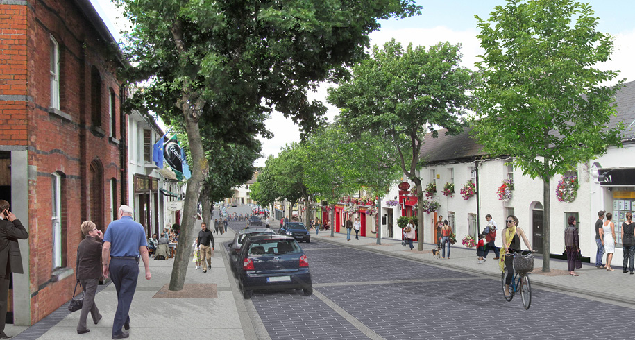
Shopfronts
The front of a shop, which includes any signage, is the public face of that premises. Good shopfront design makes a valuable contribution to the quality of shopping areas. Poor quality shopfronts can seriously erode the character of a streetscape and be visually intrusive. The scope of shopfronts encompasses not only shops but other business frontages such as restaurants, public houses, banks, offices and any ground floor activity on our main streets.
Careful management needs to be exercised with regard to shopfront treatment. High quality contemporary design will be encouraged for new shopfronts. However, any new shopfront design will have to respect the character and architectural heritage of existing streetscapes.
Corporate logos, designs and colours may not be appropriate in all locations. The use of film or screening that obscures the glazed area of a shopfront window will be discouraged. The use of such material often creates a sense of dead frontage on a streetscape. Security shutters can be another source of visual clutter and careful management of these is required. New security shutters should be positioned behind the window glazing in the interest of visual amenity.
A guidance document has been drafted in relation to the provision of high quality shop fronts for Malahide. This draft document outlines Guiding Design Considerations which are relevant to all shopfront design and are set out below. Additional guidance documents will be produced for other areas throughout the County.
|
Malahide Public Realm Strategy – Design Guide for Shopfronts |
|---|
|
All shopfront design, whether it be modern or traditional, should consider the streetscape, the building itself and the design detail of the shop unit. The StreetscapeIt is important to be aware of the street’s character and to consider the effect the design might have on the streetscape. Shopfronts should reflect the historic urban grain, building widths and contribute to good design and traditional character of the village. The BuildingIt is important to consider the effect the shopfront might have on the building itself, as well as the adjoining buildings and shopfronts. Good shopfront design should be sensitive to the character of the building, particularly where it is within the ACA, and maintain its traditional frontage. It is important to maintain a vertical emphasis, and have a relationship with the first floor opes/window alignments and proportions. Sizing and colour of signage/fascia relative to the wall of the shop is also important. |
|
Malahide Public Realm Strategy – Design Guide for Shopfronts contd. |
|---|
The DetailThe design details of the shopfront are of high importance. Ornaments, windows, door detail and associated colours provide a visual interest and should be maintained. The colour of the shopfront should be carefully considered and should enhance the building as well as the streetscape. |
|
Produce guidance for quality shopfront designs for designated locations throughout the County to be determined in consultation with the relevant stakeholders. |
|
Ensure new shopfront design respects the character and architectural heritage of the existing streetscape. Encourage, where appropriate, the use of contemporary shop front design. |
|
Prevent the use of film or screening that obscures the glazed area of a shopfront window where it negatively impacts upon the streetscape. |
|
Ensure that corporate logos, lighting, designs and colours are not used at the expense of the streetscape. |
|
Require that security shutters on new shopfronts are placed behind the window glazing and are transparent and encourage the use of transparent security shutters in all existing shopfronts having regard to a history of vandalism. |
Other Signage
The presence and location of signage can have a major impact on the visual amenity of an area. Poorly positioned and unnecessary signage can reduce the overall visual quality of an area.
Particular attention will be paid to the design and location of new advertising in those areas where the Council intends to implement town and village improvement schemes in order to maximise the potential environmental benefits of such schemes and also in areas the subject of Masterplans, Urban Framework Plans or Public Realm Strategies.
Advertising signage, where permitted, should be simple in design, sympathetic to its surroundings, non-illuminated and not unduly obtrusive. The Council aims to reduce the amount of fixed structure signage and to ensure that unauthorised and redundant signage and advertisements are removed.
|
Evaluate signage proposals in relation to the surroundings and features of the buildings and structures on which signs are to be displayed, the number and size of signs in the area (both existing and proposed) and the potential for the creation of undesirable visual clutter. |
|
Encourage that any new cultural, community and civic signage around the County be displayed both in the Irish and English languages. |
|
Demonstrate energy reduction measures in new and replacement advertising structures. |
|
Resist new billboard and other large advertising structures and displays. |
|
Take enforcement measures so as to secure the removal of unauthorised advertisements from private property and to remove unauthorised advertisements from public areas. Where appropriate the Council will use the powers available under Section 209 of the Planning and Development Acts 2000, as amended, to repair, tidy or remove advertisements structures or advertisements, or use the provisions of the Litter Pollution Act. |
Green Roofs and Walls
A green roof or wall comprises part of a building that is partially or completely covered with vegetation and soil, or a growing medium, which is planted over a waterproofing membrane. Additional layers such as a roof barrier and drainage and irrigation systems are usually included as part of the green roof system.
Green roofs have a number of environmental benefits including the absorption and controlled release of rainwater rather than direct run-off into surface water drainage systems. In urban areas, they provide wildlife habitat, improve air quality, improve energy efficiency and reduce the ‘urban heat island effect’, which happens when buildings absorb and trap heat, thereby increasing the temperature in the surrounding area. The use of green roofs will be promoted and encouraged as part of an integrated approach to the provision of green infrastructure, taking particular account of benefits in terms of SuDS provision.
Green walls are also referred to as living walls, biowalls or vertical gardens and have many benefits including:
- Thermal insulation
- Good for acoustics – it absorbs sound and prevents reflections
- Good for wildlife
- Provides for carbon sequestration. Carbon sequestration is the removal and storage of carbon from the atmosphere in carbon sinks
- Visual benefits through providing visual interest in an otherwise blank facade.
|
Promote and encourage the use of green walls and roofs for new developments that demonstrate benefits in terms of SuDS as part of an integrated approach to green infrastructure provision. |
|
Promote and encourage the use of green walls and roofs as part of an integrated approach to green infrastructure provision. |
Utility Facilities
The quality of well finished buildings and high quality landscaping schemes has often been eroded by the poor location and badly thought out design of utility facilities, such as electricity substations, especially those located to the front and side of buildings. It is recognised that utility facilities are necessary, especially for larger scale developments. However, they should be sensitively located.
|
Locate, where possible, new utility structures such as electricity substations and telecommunication equipment cabinets, not adjacent to or forward of the front building line of buildings or on areas of open space. |
|
Require new utility structures such as electricity substations and telecommunication equipment cabinets to be of a high quality design and to be maintained to a high standard by the relevant service provider. |
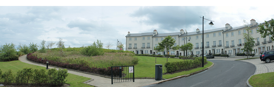
12.4 Design Criteria for Residential Development
Residential Zoning
There are two primary Draft Plan zonings for residential areas. Firstly zoning objective RS is to “provide for residential development and to protect and improve residential amenity”. The vision is to ensure that any new development in existing residential areas has a minimal impact on existing amenity. Secondly, zoning objective RA is to “provide for new residential communities subject to the provision of the necessary social and physical infrastructure”. The vision for this zoning is to ensure the provision of high quality new residential developments with good layout and design, within close proximity to community facilities, and with an appropriate mix of house sizes, types and tenures.
Some RA zoning areas will be subject to either a Local Area Plan or a Masterplan. These locations are marked on the Draft Development Plan maps.
Mix of Dwelling Types
The dwelling mix in any residential scheme should provide a balanced range of dwelling types and sizes to support a variety of household types. On smaller infill sites, the mix of dwellings should contribute to the overall dwelling mix in the locality.
Design Statements for residential or mixed use development proposals with a residential element will be required to address the mix of dwelling types.
Residential Density
In general the number of dwellings to be provided on a site should be determined with reference to the Departmental Guidelines document Sustainable Residential Development in Urban Areas – Guidelines for Planning Authorities (2009). As a general principle and to promote sustainable forms of development, higher residential densities will be promoted within walking distance of town and district centres and high capacity public transport facilities.
Apartment Development
Apartment developments should be of high quality design and site layout having due regard to the character and amenities of the area. Apartment developments are encouraged to provide dual aspect units. Furthermore, it is essential that apartment developments should provide a mix of units to cater for different size households.
As per the Department guidelines, there is a requirement that the minimum number of dual aspect apartments that may be provided in any single apartment scheme shall be 50%. In certain circumstances, usually on inner urban sites, near to city or town centres, including SDZ areas, where it is necessary to ensure good street frontage and subject to high quality design, this may be further reduced to an absolute minimum of 33%. Ideally, 3 bedroomed apartments should be dual aspect. These requirements may be relaxed where it is proposed to refurbish an older building in a constrained urban context. North facing single aspect apartments will only be considered where overlooking a significant amenity such as a public park, garden or formal space, or a water body or some other amenity feature.
Ground level apartment floor to ceiling heights shall be a minimum of 2.7m. This is an absolute minimum requirement and applicants should consider the potential for increasing the minimum apartment floor-to-ceiling height to 2.7 metres where height restrictions would not necessitate a reduction in the number of floors and should consider 3.0 metres on the ground floor of multi-storey buildings.
Up to 8 apartments per floor per individual stair/lift core may be provided in apartment schemes. Where, this is not be possible, applicants and developers should maximise the number of apartments per floor per stair/lift core.
|
Require the provision of a minimum of 50% of apartments in any apartment scheme are dual aspect. |
|
Allow a reduced percentage of dual aspect apartments only in circumstances where it is necessary to ensure good street frontage and subject to high quality design. In no instance will the provision be less than 33% of the number of apartments in the scheme. |
|
Require a minimum floor to ceiling height of 2.7 metres in apartment units, at ground floor level. |
|
Permit up to 8 apartments per floor per individual stair/lift core within apartment schemes. |
Quantitative Standards
The design and layout of individual dwellings should provide a high quality living environment for residents. Designers should have regard to the targets and standards set out in Tables 12.1, 12.2 and 12.3. with regard to minimum room sizes, dimensions and overall floor areas when designing residential accommodation. Dwellings should also be designed to provide adequate room sizes that create good quality and adaptable living spaces.
In order to ensure good quality development, it is a requirement that the majority of all apartments in a proposed scheme of 100 or more apartments must exceed the minimum floor area standard for any combination of the relevant 1, 2 or 3 bedroom unit types, by a minimum of 10% (any studio apartments must be included in the total, but are not calculable as units that exceed the minimum by at least 10%). For developments of between 10 and 99 units, this requirement is varied to allow greater flexibility. In such schemes it is acceptable to redistribute part of the minimum 10% additional floorspace requirement throughout the scheme, i.e. to all proposed units.
In general, adequate space should be provided for the following:
- The normal range and typical arrangement of furniture for each room
- A reasonable degree of freedom of circulation, appropriate to the likely activities
- The movement of larger items of furniture into and between rooms
- Space for family gatherings, including occasional visitors
- Working area and storage facilities appropriate to likely activities
- Door swings which do not interfere with other doors, furniture or circulation routes
- The location of radiators and other service fittings in a way that does not limit the arrangement of furniture within a room
|
Require that new residential units comply with or exceed the minimum standards as set out in Tables 12.1, 12.2 and 12.3. |
|
Require that the majority of all apartments in a proposed scheme of 100 or more apartments must exceed the minimum floor area standard for any combination of the relevant 1, 2 or 3 bedroom unit types, by a minimum of 10%. |
|
For apartment schemes between 10 and 99 units, require that the majority of all apartments in a proposed scheme of must exceed the minimum floor area standard for any combination of the relevant 1, 2 or 3 bedroom unit types, by a minimum of 10%. This may be redistributed throughout the scheme, i.e. to all proposed units. |
|
Require that all planning applications for residential development include floor plans for each room indicating typical furniture layouts and door swings. |
Table 12.1 Houses
|
Dwelling Type |
Number of floors |
Minimum Gross Floor Area (sq m) |
Dwelling Main Living Room (sq m) |
Dwelling Aggregate Living Area (sq m) |
Dwelling Aggregate Bedroom Area (sq m) |
Storage Area (sq m) |
|---|---|---|---|---|---|---|
|
4 Bed/ 7 Pers. |
3 |
120 |
15 |
40 |
43 |
6* |
|
4 Bed/ 7 Pers. |
2 |
110 |
15 |
40 |
43 |
6* |
|
4 Bed/ 7 Pers. |
1 |
100 |
15 |
40 |
43 |
6* |
|
4 Bed/ 6 Pers. |
3 |
115 |
15 |
37 |
36 |
6* |
|
4 Bed/ 6 Pers. |
2 |
105 |
15 |
37 |
36 |
6* |
|
4 Bed/ 6 Pers. |
1 |
95 |
15 |
37 |
36 |
6* |
|
4 Bed/ 5 Pers. |
3 |
107 |
13 |
34 |
32 |
5* |
|
4 Bed/ 5 Pers. |
2 |
97 |
13 |
34 |
32 |
5* |
|
4 Bed/ 5 Pers. |
1 |
87 |
13 |
34 |
32 |
5* |
|
3 Bed/ 6 Pers. |
3 |
110 |
15 |
37 |
36 |
6* |
|
3 Bed/ 6 Pers. |
2 |
100 |
15 |
37 |
36 |
6* |
|
3 Bed/ 6 Pers. |
1 |
90 |
15 |
37 |
36 |
6* |
|
3 Bed/ 5 Pers. |
3 |
102 |
13 |
34 |
32 |
5* |
|
3 Bed/ 5 Pers. |
2 |
92 |
13 |
34 |
32 |
5* |
|
3 Bed/ 5 Pers. |
1 |
82 |
13 |
34 |
32 |
5* |
|
3 Bed/ 4 Pers. |
3 |
93 |
13 |
30 |
28 |
4* |
|
3 Bed/ 4 Pers. |
2 |
83 |
13 |
30 |
28 |
4* |
|
3 Bed/ 4 Pers. |
1 |
73 |
13 |
30 |
28 |
4* |
|
2 Bed/ 4 Pers. |
2 |
80 |
13 |
30 |
25 |
4.5* |
|
2 Bed/ 4 Pers. |
1 |
70 |
13 |
30 |
25 |
4.5* |
|
2 Bed/ 3 Pers. |
2 |
70 |
13 |
28 |
20 |
3.5* |
|
2 Bed/ 3 Pers. |
1 |
64 |
13 |
28 |
20 |
3.5* |
|
1 Bed/ 2 Pers. |
1 |
50 |
11 |
23 |
11.4 |
2.5 |
Table 12.2 Apartments / Duplexes
|
Dwelling Type |
Minimum Gross Floor Area (sq m) |
Aggregate Living Area (sq m) |
Aggregate Bedroom Area (sq m) |
Storage Area (sq m) |
|---|---|---|---|---|
|
3 bed |
90 |
34 |
31.5 |
9 |
|
2 bed |
73 |
30 |
24.4 |
6 |
|
1 bed |
45 |
23 |
11.4 |
3 |
* No individual storage room within an apartment/duplex should exceed 3.5 sq m. Some storage may be provided in a basement or carpark area, this may be used to satisfy up to half of the minimum storage requirement for individual apartment units.
Table 12.3 Minimum Room Sizes and Widths for Houses and Apartments
|
Minimum bedroom size (Minimum bedroom floor areas exclude built in storage space) |
|
|
Single bedroom |
7.1 sq m |
|
Double bedroom |
11.4 sq m |
|
Double bedroom including en-suite |
13 sq m |
|
Minimum room widths Living Room One bedroom Two bedroom Three Bedroom |
3.3 metres 3.6 metres 3.8 metres |
|
Double bedroom |
2.8 metres |
|
Single bedroom |
2.1 metres |
Separation Distances
A minimum standard of 22 metres separation between directly opposing rear first floor windows shall be observed, normally resulting in a minimum rear garden depth of 11 metres. However, where sufficient alternative private open space (e.g. to the side) is available, this may be reduced - subject to the maintenance of privacy and protection of adjoining residential amenities.
All proposals for residential development, particularly apartment developments, over three storeys high, shall provide for acceptable separation distances between blocks to avoid negative effects such as excessive overlooking, overbearing and overshadowing effects and provide sustainable residential amenity conditions and open spaces. The minimum standard distance of 22 metres between opposing windows will apply in the case of apartments up to three storeys in height. In taller blocks, a greater separation distance may be prescribed having regard to the layout, size and design. In certain instances, depending on orientation and location in built-up areas, reduced separation distances may be acceptable. Any relaxing of standards will be assessed on a case-by-case basis and should not be seen as setting a precedent for future development.
|
A separation distance of a minimum of 22 metres between directly opposing rear first floor windows shall generally be observed unless alternative provision has been designed to ensure privacy. In residential developments over 3 storeys, minimum separation distances shall be increased in instances where overlooking or overshadowing occurs. A separation distance of at least 2.3 metres should be provided between the side walls of each house, pair of semi-detached houses or each terrace of houses in order to allow for adequate maintenance and access. |
|
Ensure a separation distance of at least 2.3 metres is provided between the side walls of detached, semi-detached and end of terrace units. |
Daylight, Sunlight and Overshadowing
High levels of daylight and sunlight provide for good levels of amenity for residents. The internal layout of residential units should be designed to maximise use of natural daylight and sunlight. Daylight and sunlight levels, as a minimum, should be in accordance with Site Layout Planning for Daylight and Sunlight: A Guide to Good Practice (B.R.E. 1991) and British Standard (B.S.). 8206 Lighting for Buildings, Part 2 2008: Code of Practice for Daylighting or any update on these documents.
|
Ensure all new residential units comply with the recommendations of Site Layout Planning for Daylight and Sunlight: A Guide to Good Practice (B.R.E. 1991) and B.S. 8206 Lighting for Buildings, Part 2 2008: Code of Practice for Daylighting or other updated relevant documents. |
Acoustic Privacy
Acoustic privacy is a measure of sound insulation between dwellings and between external and internal spaces. Excessive transmission of sound between structurally adjoining residential units can cause a nuisance to occupiers. New residential units must be constructed to a high standard to ensure transmission of sound is within acceptable standards. Development should have regard to the guidance on sound insulation and noise reduction for buildings contained in 2014 Building Regulations Technical Guidance Document Part E. The following principles are recommended for minimising disruption from noise in residential units:
- Utilise the site and building layout to maximise acoustic privacy by providing good building separation within the development and from neighbouring buildings and noise sources
- Arrange units within the development and the internal layout to minimise noise transmission by locating busy, noisy areas next to each other and quieter areas next to quiet areas
- Keep stairs, lifts, and service and circulation areas away from noise-sensitive rooms like bedrooms. Particular attention should be paid to the siting and acoustic isolation of the lift motor room.
|
Require that sound transmission levels in semi-detached, terraced, apartments and duplexes units comply as a minimum with the 2014 Building Regulations Technical Guidance Document Part E or any updated standards and evidence will need to be provided by a qualified sound engineer that these levels have been met. |
Open Plan Estates
It is important to maintain the openness of residential development, particularly schemes where openness is a defining feature of the development. This can be achieved through the removal of the exempted development rights with regard to the provision of boundary walls, railing or other features to the front of houses.
Gated Communities
Gated communities are communities or developments in which access to the public is not readily available due to the erection of different types of physical barriers. Gated communities serve to exclude and divide communities and do not support the development of a permeable, connected and linked urban area.
|
Prohibit proposals that would create a gated community for any new residential developments. |
Management Companies and Facilities for Apartment Developments
Higher density apartment type development will require a management company to maintain communal areas. Higher density apartment type development should consider the provision of common service areas such as laundry rooms, storage facilities, management offices and communal rooms for the enjoyment of all the residents.
|
Require properly constituted management companies in apartment type schemes are set up and necessary management structures are put in place for the benefit of the residents. |
|
Provide in high density apartment type schemes in excess of 100 units facilities for the communal use of residents as deemed appropriate by the Council. |
|
Require the provision of communal laundry rooms and storage cellars in high density apartment type developments where deemed appropriate. |
Refuse Storage and Bins
Storage of refuse bins can be an issue in new residential schemes, where adequate storage storage, recycling and composting areas, and future expansion of separated waste disposal may have to be accommodated.
In the case of communal refuse storage provision, the collection point for refuse should be accessible both to the external collector and to the resident and be secured against illegal dumping by non-residents. In the case of individual houses, the applicant shall clearly show within a planning application the proposed location and design of bin storage to serve each dwelling, and having regard to the number of individual bins required to serve each dwelling at the time of the application and any possible future requirements for refuse storage/collection.
|
Ensure all new residential schemes include appropriate design measures for refuse storage areas, details of which should be clearly shown at pre-planning and planning application stage. Ensure refuse storage areas are not situated immediately adjacent to the front door or ground floor window, unless adequate screened alcoves or other such mitigation measures are provided. |
|
Ensure the maximum distance between the front door to a communal bin area does not exceed 50 metres. |
Naming of New Residential Areas
The naming of a residential area should be carefully considered and have a local significance.
|
Naming of streets and residential estates shall reflect the local placenames and local people of note, heritage, language or topographical features as appropriate and shall incorporate old placenames from the locality as much as possible and where appropriate shall be in Irish. The use of bi-lingual signage will be required. |
Pigeon Lofts
Location
Pigeon lofts should be located as far as possible from neighbouring dwellings. In general, they should be a minimum distance of 10 metres from adjoining residential units, but in locations where this is not possible, the particular circumstances of each case will be considered.
Construction
Pigeon lofts should be of sound construction with a concrete floor or sub-floor. They should be constructed so as to ensure ease of cleaning and to provide adequate ventilation, while being secure against rodents.
Design
The external design and finish of pigeon lofts should be of good quality and they should be maintained in good condition.
Height and Area
The appropriate size of a loft would depend on the nature of the property and the proximity of neighbours. As a general rule, pigeon lofts should not exceed 25 sq m in area, and should have a maximum height of 3 metres with a pitched roof, or 2.5 metres with a flat roof.
Restrictions
In no circumstances will an open loft be permitted. (An open loft is one which pigeons may enter or leave at any time).
Other Residential Development
The development of underutilised infill and corner sites in existing residential areas is generally encouraged. However, it is recognised that a balance is needed between the protection of amenities, privacy, the established character of the area and new residential infill. The use of contemporary and innovative design solutions will be encouraged for this type of development.
Corner site development refers to sub-division of an existing house curtilage and/or an appropriately zoned brownfield site to provide an additional dwelling in existing built up areas.
All new dwellings shall comply with Development Plan standards in relation to accommodation size, garden size and car parking. Where the proposed height is greater than that of the surrounding area a transitional element should be provided.
|
New infill development shall respect the height and massing of existing residential units. Infill development shall retain the physical character of the area including features such as boundary walls, pillars, gates/gateways, trees, landscaping, and fencing or railings. |
|
New corner site development shall have regard to:
|
Extensions to Dwellings
The need for people to extend and renovate their dwellings is recognised and acknowledged. Extensions will be considered favourably where they do not have a negative impact on adjoining properties or on the nature of the surrounding area.
First floor rear extensions will be considered on their merits, noting that they can often have potential for negative impacts on the amenities of adjacent properties. The Planning Authority must be satisfied there will be no significant negative impacts on surrounding residential or visual amenities. The following factors will be considered:
- Overshadowing, overbearing and overlooking, along with proximity, height and length along mutual boundaries.
- Remaining rear private open space, and its usability.
- External finishes and design, which shall generally match the existing.
Ground floor rear extensions will be considered in terms of their length, height, proximity to mutual boundaries and remaining usable rear private open space. Side extensions will be evaluated against proximity to boundaries, size and visual harmony with existing (especially front elevation), and impacts on residential amenity. First floor side extensions built over existing structures and matching existing dwelling design and height will generally be acceptable. Though in certain cases a set-back of an extension’s front facade and its roof profile and ridge may be sought to protect amenities, integrate into the streetscape and avoid a ‘terracing’ effect. External finishes shall generally match the existing.
Roof alterations/expansions to main roof profiles, for example, changing the hip-end roof of a semi-detached house to a gable/‘A’ frame end or ‘half-hip’, will be assessed against a number of criteria including:
- Consideration and regard to the character and size of the structure, its position on the streetscape and proximity to adjacent structures.
- Existing roof variations on the streetscape.
- Distance/contrast/visibility of proposed roof end.
- Harmony with the rest of the structure, adjacent structures and prominence.
Dormer extensions to roofs will be considered with regard to impacts on existing character and form, and the privacy of adjacent properties. The design, dimensions and bulk of any roof proposal relative to the overall size of the dwelling and gardens will be the overriding considerations. Dormer extensions (whether for functional roof space or light access) shall generally not form a dominant part of a roof. Consideration may be given to dormer extensions proposed up to the ridge level of a house, but in all cases no dormer extension shall be higher than the existing ridge height of the house. The proposed quality of materials/finishes for dormers will be considered carefully as this can greatly improve their appearance. The level and type of glazing within a dormer structure should have regard to existing window treatments and fenestration of the dwelling.
|
Dormer extensions to roofs will be only be considered where there is no negative impact on the existing character and form, and the privacy of adjacent properties. Dormer extensions shall not form a dominant part of a roof. Consideration may be given to dormer extensions proposed up to the ridge level of a house and shall not be higher than the existing ridge height of the house. |
|
Encourage more innovative design approaches for domestic extensions. |
Family Flats
Family flats (often known as granny flats) are a way of providing additional accommodation with a level of independence for an undefined temporary period of time. Family flats allow for semi-independent accommodation for an immediate family member (dependent on the main occupants of the dwelling). Applications for family flats will be considered favourably subject to criteria set out in Objective DMS 43 below.
|
Ensure family flats:
|
Residential Areas of Character
There are residential areas in the County that have uniqueness through their design, character, density and height. New developments within residential areas considered to be of noted character should respect the overall character of the area.
|
Protect areas with a unique, identified residential character which provides a sense of place to an area through design, character, density and/or height and ensure any new development in such areas respects this distinctive character. |
Student Accommodation
All proposals for student accommodation should comply with the Department of Education and Science Guidelines on Residential Development for Third Level Students (1999), the subsequent supplementary document (2005) and the ‘Student Accommodation Scheme’, Office of Revenue Commissioner (2007). These documents provide definitions of ‘students’ and ‘educational institutions’ and recommendations in relation to minimum bed-space and other similar requirements.
Given the growth in recent years of the number of third level students, there is a demand for specific residential accommodation to cater for this need.
|
Support the provision of on-campus accommodation and consider the provision of student accommodation off-campus having regard to:
|
In all schemes the applicants will be required to provide a written documentary confirmation for a ‘Qualifying Lease’ as defined in the Guidelines on Residential Developments for Third Level Students published by the Department of Education and Science in 1999 and - noting the supplementary review document in 2005 - to prove that the accommodation is let to students within the academic year.
All permissions for student housing shall have a condition attached requiring planning permission for a change of use from student accommodation to other type of accommodation. Future applications for this type of change of use will be resisted except where it is demonstrated that continuing over-provision of student accommodation exists in the County.
Residential Care Homes, Retirement Homes, Nursing Homes and Retirement Villages
The Council recognises that the provision of care for the elderly and other vulnerable people is an essential community requirement. Although there has been pressure for such facilities in rural areas, there is a presumption against this type of development in the open countryside for reasons relating to sustainability, poor accessibility and lack of public transport, social exclusion and isolation.
|
Require that residential care homes, retirement homes, nursing homes and retirement villages be located in towns and villages for reasons of sustainability, accessibility, social inclusion, and proximity to the availability of service, except where a demonstrated need to locate in a rural environment because of the nature of the care required can be clearly established. |
|
Require that applications for residential care homes, retirement homes, nursing homes and retirement villages consider and demonstrate the following:
|
It is essential that adequate and suitable open space area and other facilities are provided for residential care homes, retirement homes, nursing homes and retirement villages. It is recognised that reduced quantity standards may be appropriate in some cases due to the level of care that is provided or by virtue of the location of the facility. Planning applications for such development should include detailed open space and landscaping plans that take account of the location of the facility, the availability/ suitability of existing open space and the needs of the residents of the facility.
|
Accept reduced open space quantity standards for certain developments, namely residential care homes, retirement homes, nursing homes and retirement villages where a reduction is deemed appropriate by virtue of the specific open space needs of the residents and where suitable accessible open space is available. High quality open space and landscaping plans shall be submitted with planning applications for these developments. |
12.5 Design Criteria for Rural Villages and Rural Clusters
Chapter 5, Rural Fingal, sets out the development approach for the Rural Villages and Rural Clusters. The rural settlement strategy in Chapter 5 also sets out the requirements to meet the housing need for areas zoned Rural Cluster.
The designated Rural Villages of Fingal are Ballyboghil, Balscadden, Coolquay, Garristown, Kinsaley, Naul, Oldtown, Rivermeade and Rowlestown. These are mostly traditional village-type settlements, and have the RV zoning objective which aims to protect the special character of Rural Villages and provide for improved village facilities and local housing need in accordance with approved Local Area Plans and infrastructure provision. Village development shall be guided by the adopted Local Area Plans and Village Development Framework Plans.
There are 34 Rural Clusters within Fingal located at:
Balcarrick, Baldwinstown Cross, Ballykea, Blackhills (Ardgillan), Balcultry, Ballymadun, Baltrasna, Castlefarm (Kilsallaghan), Colecut, Dallyhaysy (Balbriggan), Dermotstown (Bog O’ the Ring), Grougha, Moonlone Lane (Naul), Dubber Cross, Effelstown (Lusk/Rush train station), Holmpatrick, Hedgestown (Five Roads), Jordanstown, Killalane, Magilstown, Malheney (Man O’ War), Milverton, Moyne Road, New Haggard, North Beach, Palmerstown, Staffordstown/Corduff, The Quay (Portrane), Thornton, Tobersool, The Commons (Lusk), Turvey Lane, Wimbletown (Ballyboghil) and Wyanstown (Oldtown).
Rural Clusters provide an alternative to one-off housing in the countryside through the consolidation of rural residential development within existing small clusters. Sensitive layout and design of new houses within the Rural Clusters will ensure that they contribute positively to the rural character of the area. The layout and design of new housing within the Rural Clusters should be consistent with Section 12.6 below – Design Criteria for Housing in the Countryside.
12.6 Design Criteria for Housing in the Countryside
The countryside for the purposes of this section of the Plan are those areas with the rural zoning objectives identified as Agriculture and Rural Amenity (RU), Greenbelt (GB), and High Amenity (HA). The reuse of existing buildings within the countryside for residential development will be encouraged.
The rural settlement strategy in Chapter 5 Rural Fingal sets out the requirements to meet the housing need in the areas of the County Zoned RU, GB and HA.
It is an objective of this Development Plan to limit the visual impact of new houses upon the countryside. Prior to the decision on planning permission, the visual impact of any proposed house upon the rural landscape must be evaluated.
The location of any proposed new house should be such as to limit the increase of new entrances onto any public road. Therefore, newly constructed homes will be directed, where possible, to sites which are located adjacent to existing homes or farmyards belonging to the family of the owner of the new home. Such sites should be served by a single entrance for both the existing and the proposed development.
|
Ensure that new dwellings in the rural area are sensitively sited, demonstrate consistency with the immediate Landscape Character Type, and make best use of the natural landscape for a sustainable, carbon efficient and sensitive design. A full analysis/feasibility study of the proposed site and of the impact of the proposed house on the surrounding landscape will be required in support of applications for planning permission. |
|
Ensure that any planning application for a house within an area which has a Greenbelt or High Amenity zoning objective is accompanied by a comprehensive Visual Impact Statement and Screening for Appropriate Assessment, as necessary. |
|
Encourage new dwellings in the rural area to be sited at a location in close proximity to the family home where the drainage conditions can safely accommodate the cumulative impact of such clustering and where such clustering will not have a negative visual and amenity impact on the original house. Where such an arrangement is clearly demonstrated not to be available, permit the new dwelling to be located on an alternative site which is within two kilometres from the family home, or, in the case of applications made under Objective RF37 and RF38, within two kilometres outside the Inner Noise Zone. |
Table 12.4 – Design Guidelines for Rural Dwellings
|
Design Guidelines for Rural Dwellings |
|---|
|
The Council will use the following guidance in assessing planning applications for a rural house: Site Assessment Study
|
|
Siting & Design
|
|
Materials & Detailing
|
|
Boundary Treatments
|
|
Access & Site Lines
|
|
Surface & Wastewater Treatment
|
|
Landscaping
|
|
Ensure that the design and siting of any new house conforms to the principles of Design Guidelines for Rural Dwellings as outlined in Table 12.4. |
|
Ensure that the requirements set out for on-site treatment systems are strictly complied with, or with the requirements as may be amended by future national legislation, guidance, or Codes of Practice. |
|
Development requirements where on-site treatment systems are proposed are:
|
|
Implement the recommendations of the Ground Water Protection Scheme. |
12.7 Open Space
The provision of accessible open space is an integral part of the provision of high-quality green infrastructure for communities and forms a core element in the emerging Green Infrastructure Strategy for the county. To achieve high quality open space, Fingal County Council has five basic principles of open space provision:
Hierarchy, Accessibility, Quantity, Quality and Private Open Space.
Hierarchy and Accessibility
Table 12.5, below, outlines the public open space hierarchy and accessibility standards. The standards allow the provision of a wide variety of accessible public open spaces to meet the diverse needs of the County’s residents. For all developments with a residential component a mix of public open space types should be provided where achievable.
Table 12.5 Open Space Hierarchy and Accessibility
|
Type of Public Open Space |
Areas |
Accessibility from homes |
Note |
|---|---|---|---|
|
Pocket Parks (Class 2 as per Development Contribution Scheme) Facilities for smaller children, but not necessarily formal play facilities. Have an important visual and social function also. Pocket parks must not be to the side or back of houses and must be adequately overlooked. |
Between 500 sq m – 0.2 hectares |
Every home within 150m walking distance |
Provide pocket parks in all cases. No contributions in lieu |
|
Small Parks (Class 2 as per Development Contribution Scheme) Depending on their size, these will accommodate playground facilities, kick about areas, and passive recreation. |
Between 0.2 – 2 hectares |
Within 400m walking distance of homes |
|
|
Local Parks (Class 1 as per Development Scheme) Accommodate playground facilities and a number of playing fields. Passive recreational and biodiversity areas will also be accommdated in these parks. |
Between 2 hectares – 20 hectares. |
400 metres. |
|
|
Urban Neighbourhood Parks (Class 1 as per Development Contribution Scheme). A wide variety of facilities and uses can be provided here due to their size. Biodiversity areas will also be accommodated in these parks. |
Between 20 hectares – 50 hectares |
Within 1km |
|
|
Regional Parks (Class 1 as per Development Contribution Scheme) Provide for a large range of uses. Formal and informal play areas, passive recreation areas, biodiversity areas and often a distinct attraction will be available on site. |
Over 50 hectares |
Within 5km |
- *Areas not counted in the Open Space calculation include:
- Environmental Open Space, i.e. incidental or narrow pieces of open space used for the preservation of trees and or as a visual relief and screen planting e.g. along roads.
- Green corridors
- Areas of open space under high voltage electricity lines.
Where any open space is to be provided on foot of a planning permission, the space in question should be well overlooked and designed and located to sympathetically complement the layout of the development and should be visible from, and accessible to, the maximum number of dwellings/units within the proposed scheme. Inaccessible, hidden or otherwise backland open space and narrow linear strips of open space will not be acceptable. Fragmented open spaces within a development layout, which result specifically from the necessity to protect existing site features (for example a stand of mature trees) may not be included in the calculation open space requirements, as they are necessary to ensure the protection of existing amenities.
Public and/or communal open spaces should be overlooked and designed to ensure that potential for anti-social behaviour is minimised through passive surveillance. ‘Sustainable Residential Development in Urban Areas - Guidelines for Planning Authorities’ (2009) provides detailed guidance on the provision of open space for new residential developments while the ‘Retail Design Manual’ (2012) provides guiding principles on how landscaping and open spaces can assist improved public realm and promote attractive retailing centres.
Permeability and accessibility is essential as part of an integrated approach to the provision of linked open spaces. Where pedestrian and cycleway opportunities are presented, substantial links between developments will be encouraged. Where developments adjoin, links through amalgamating the open space shall be provided.
|
Integrate and provide links through adjoining open spaces to create permeable and accessible areas, subject to Screening for Appropriate Assessment and consultation, including the public, as necessary. |
Quantity
For all developments with a residential component, the overall standard for public open space provision is a minimum 2.5 hectares per 1000 population. In order to provide existing and future communities with adequate recreational and leisure opportunities, the Council will employ a flexible approach to the delivery of public open space and more intensive recreational/amenity facilities. It is the intention of the Council, however, to ensure, except under exceptional
circumstances, public open space provision exceeds 10% of a development site area. The development site area cannot include lands zoned RU, GB, OS or HA.
|
Require a minimum public open space provision of 2.5 hectares per 1000 population. For the purposes of this calculation, public open space requirements are to be based on residential units with an agreed occupancy rate of 3.5 persons in the case of dwellings with three or more bedrooms and 1.5 persons in the case of dwellings with two or fewer bedrooms. |
|
Require a minimum 10% of a proposed development site area be designated for use as public open space. The Council has the discretion for the remaining open space required under Table 12.5 to allow provision or upgrade of small parks, local parks and urban neighbourhood parks and/or recreational/amenity facilities outside the development site area, subject to the open space or facilities meeting the open space ‘accessibility from homes’ standards for each public open space type specified in Table 12.5. The Council has the discretion for the remaining open space required under Table 12.5 to allow provision or upgrade of Regional Parks in exceptional circumstances where the provision or upgrade of small parks, local parks and urban neighbourhood parks and/or recreational/amenity facilities is not achievable. This is subject to the Regional Park meeting the open space ‘accessibility from homes’ standard specified in Table 12.5. |
|
Require a minimum 10% of a proposed development site area be designated for use as public open space. The Council has the discretion to accept a financial contribution in lieu of remaining open space requirement required under Table 12.5, such contribution being held solely for the purpose of the acquisition or upgrading of small parks, local parks and urban neighbourhood parks and/or recreational/amenity facilities subject to the open space or facilities meeting the open space ‘accessibility from homes’ standards for each public open space type specified in Table12.5. The Council has the discretion to accept a financial contribution in lieu of the remaining open space requirement to allow provision or upgrade of Regional Parks in exceptional circumstances where the provision or upgrade of small parks, local parks and urban neighbourhood parks and/or recreational/amenity facilities is not achievable, subject to the Regional Park meeting the open space ‘accessibility from homes’ standard specified in Table 12.5. Where the Council accepts financial contributions in lieu of open space, the contribution shall be calculated on the basis of 25% Class 2 and 75% Class 1 in addition to the development costs of the open space. |
|
Require an equivalent financial contribution in lieu of open space provision in smaller developments of less than three units where the open space generated by the development would be so small as not to be viable. Where the Council accepts financial contribution in lieu of open space, the contribution shall be calculated on the basis of 25% Class 2 and 75% Class 1. |
|
Ensure every home within a new residential scheme is located within 150 metres walking distance of a pocket park, small park, local park, urban neighbourhood park or regional park. |
|
Require the monetary value in lieu of open spaces to be in line with the Fingal County Council Development Contribution Scheme. |
|
Retain in open space use institutional lands, landscaped demesnes and similar properties with established recreational or amenity uses, as far as practicable. However, in the event of permission for development being granted on these lands, open space provision in excess of the normal standards will be required to maintain the open character of such parts of the land as are considered necessary by the Council for this purpose. |
|
Areas of open space of less than 500 square metres will not be taken in charge by Fingal County Council for maintenance purposes. |
|
Open space areas designed to a highly ornate and unsustainable standard will not be taken in charge as public open space. |
Intensive Recreational Facilities
In certain circumstances, where the open space standards cannot be achieved or where more intensive recreational uses are deemed to be desirable, the Council may consider arrangements whereby appropriate intensive facilities may be provided in lieu of open space of lesser utility.
|
Require a minimum open space provision equal to 70% of the open space requirement in addition to intensive recreational/ amenity facilities. |
Quality
Design of Public Open Spaces
Open spaces must be designed to a high specification. Great emphasis must be placed on the quality and long-term sustainability of open space and details of the proposed landscaping, hard and soft, of these spaces will be required at the planning application stage. Public open spaces should be overlooked and designed in such a way that anti-social behaviour is reduced through passive surveillance. Potential for anti-social behaviour associated with open spaces and associated screen planting must be designed out.
|
Ensure open spaces are not located to the side or the rear of housing units. |
|
Ensure open space provision is suitably proportioned and inappropriate narrow tracts are not provided. |
|
Ensure, where possible, complementary facilities, such as dressing rooms and storage facilities, are provided as part of the open space provision. |
|
Ensure developers lay out and maintain open space areas to a high standard, until such a time as they are taken in charge and facilitate the early handover of areas of public open space to the Council. The Council, at its discretion, may in certain circumstances accept a financial contribution in order to complete the landscaping and development of these areas. |
|
Require properly constituted management companies to be set up and ensure that the necessary management structures are put in place where it is intended that open spaces will be retained in private ownership. Arrangements must be approved by the Council before completion of the project and must be in operation before release of required bonds. |
Green Corridors
Green corridors are linear open spaces along paths, water courses, planting or other natural features that provide opportunities for walking and cycling, informal recreation, and biodiversity and wildlife migration. They will not generally be included as part of the quantitative calculation for open space provision, except with the agreement of the Planning Authority. Green corridors should be incorporated into all new large developments, as part of Green Infrastructure provision, linking large areas of open space and linking with areas outside the development site.
|
Provide green corridors in all new developments where the opportunity exists. |
Green Roofs
In addition to their environmental benefits, green roofs also provide potential for additional amenity space, particularly in high density development. Green roofs do not form part of the public open space provision.
|
Encourage the use of green roofs as amenity space. |
Sustainable urban Drainage Systems
Sustainable urban Drainage Systems (SuDS) can best be defined as offering a “total” solution to rainwater management and must be included in all new developments. Ponds, artificial wetlands and water features can make a positive contribution to the provision of Sustainable Drainage Systems (SuDS) and to the amenity of an area. Properly designed and located SuDS features can be incorporated within and can complement the amenity and aesthetic value of open spaces.
SuDS areas do not form part of the public open space provision, except where they contribute in a significant way to the design and quality of open space. The determination shall be at the discretion of the Planning Authority.
|
Ensure as far as practical that the design of SuDS enhances the quality of open spaces. SuDS do not form part of the public open space provision, except where it contributes in a significant and positive way to the design and quality of open space. In instances where the Council determines that SuDS make a significant and positive contribution to open space, as determined by the Council, a maximum 10% of open space provision shall be taken up by SuDS. The Council will give consideration to the provision of SuDS on existing open space, where appropriate. |
|
Underground tanks and storage systems will not be accepted under public open space, as part of a SuDS solution. |
Playground Facilities
Playground facilities should cater for defined age groups and provide for a variety of facilities and play opportunities. All residential schemes in excess of 50 units should incorporate playground facilities which should be provided at a rate of 4 sq m per residential unit.
|
Provide appropriately scaled children’s playground facilities within residential development. Playground facilities shall be provided at a rate of 4 sq m per residential unit. All residential schemes in excess of 50 units shall incorporate playground facilities clearly delineated on the planning application drawings and demarcated and built, where feasible and appropriate, in advance of the sale of any units. |
|
Ensure that in the instance of an equipped playground being included as part of a specific facility, it shall occupy an area of no less than 0.02 hectares. A minimum of one piece of play equipment shall be provided for every 50 sq m of playground. |
Tree Policy
Trees provide both valuable amenity and wildlife habitat. Visually they add to an area, softening the impact of physical development on the landscape while also fulfilling an important role in the improvement of air quality in urban areas and providing wildlife habitats. ‘The Forest of Fingal – A Tree Strategy for Fingal' sets out the Council’s policy for street tree planting, management and maintenance.
|
Protect, preserve and ensure the effective management of trees and groups of trees. |
|
Ensure during the course of development, trees and hedgerows that are conditioned for retention are fully protected in accordance with ‘BS5837 (2012) Trees in relation to the Design, Demolition and Constructions – Recommendations’ or as may be updated. |
|
Require the use of native planting where appropriate in new developments in consultation with the Council. |
|
Ensure trees, hedgerows and other features which demarcate townland boundaries are preserved and incorporated where appropriate into the design of developments. |
|
Consider in tree selection the available rooting area and proximity to dwellings or business premises particularly regarding shading of buildings and gardens. |
|
Promote the planting of large canopy trees on public open space and where necessary provide for constructed tree pits as part of the landscape specification. |
|
Ensure roadside verges have a minimum width of 2.4 metres at locations where large trees are proposed and where necessary provide for constructed tree pits as part of the landscape specification. Road verges shall be a minimum of 1.2 metre wide at locations where small canopy trees are proposed. |
Private Open Space
All residential units be they traditional type housing or apartments are to be provided with private open space. Open space standards will set out qualitative and quantitative standards so as to ensure that the maximum benefit is derived from the open space.
|
Ensure trees removed from residential areas are replaced, where appropriate, as soon as resources allow. |
|
Ensure private open spaces for all residential unit types are not unduly overshadowed. |
|
Ensure boundary treatment associated with private open spaces for all residential unit types is designed to protect residential amenity and visual amenity. |
Houses
One of the characteristics of traditional type housing is the provision of private open space, usually to the rear of the front building line of the house.
|
Ensure a minimum open space provision for dwelling houses (exclusive of car parking area) as follows:
Narrow strips of open space to the side of houses shall not be included in the private open space calculations |
|
Allow a reduced standard of private open space for 1 and 2 bedroom townhouses only in circumstances where a particular design solution is required such as to develop small infill/ corner sites. In no instance will the provision of less than 48 sq m of private open space be accepted per house. |
Apartments and Duplex
Private open space associated with apartments and duplexes is important to ensure a suitable level of amenity for occupiers. Balconies and terraced areas are the primary form of private open space for apartment and duplex type schemes.
The provision and proper future maintenance of well-designed communal amenity space is essential in meeting the amenity needs of residents. Whilst private and communal amenity space may adjoin each other, there should generally be a clear distinction with an appropriate boundary treatment and/or a ‘privacy strip’ between the two.
Designers should have regard to the targets and standards set out in Table 12.6 with regard to minimum space provision.
|
Require private balconies, roof terraces or winter gardens for all apartments and duplexes comply with or exceed the minimum standards set out in Table 12.6. |
|
Require balconies, ground floor private open space, roof terraces or winter gardens be suitably screened in a manner complimenting the design of the building so as to provide an adequate level of privacy and shelter for residents. |
|
Require communal amenity space within apartment developments, in the form of semi-private zones such as secluded retreats and sitting out areas, complies with or exceeds the minimum standards set out in Table 12.6. |
|
Permit in appropriate layouts (e.g. courtyard layouts) the provision of a combination of private and semi-private open spaces. |
Table 12.6 – Open Space requirement for Apartment and Duplex
|
Private amenity space |
Communal Amenity Space |
|
|---|---|---|
|
Studio |
4 sqm |
4 sqm |
|
One bed |
5 sqm |
5 sqm |
|
Two bed |
7 sqm |
7 sqm |
|
Three bed |
9 sqm |
9 sqm |
12.8 Community Infrastructure, Facilities and Services
Community Buildings
As a general principle the location and provision of community facilities is a pre-requisite to the creation and enhancement of viable, sustainable and successful local communities.
|
Any application for community facilities such as leisure facilities, sports grounds, playing fields, play areas, community halls, organisational meeting facilities, medical facilities, childcare facilities, new school provision and other community orientated developments, shall have regard to the following:
|
Childcare Facilities
It is recognised that childcare must be of suitably high quality. The Council will seek to facilitate the provision of childcare facilities in appropriate locations throughout the County and may require their provision in large residential, public community, commercial and retail developments in accordance with the provisions of the DoEHLG ‘Childcare Facilities Guidelines for Planning Authorities’ (2001).
|
Any application for childcare facilities shall have regard to the following:
|
Applications for childcare facilities in existing residential areas will be treated on their own merits, having regard to the likely effect on the amenities of adjoining properties, and compliance with the above criteria. Detached houses or substantial semi-detached properties are most suitable for the provision of full day care facilities. For new residential developments, the most suitable facility for the provision of full day care should be a purpose built, ground floor, stand-alone property.
|
Residential properties with childcare shall retain a substantial residential component within the dwelling, and shall be occupied by the operator of the childcare facility. |
In assessing applications for new childcare facilities, the Planning Authority will consult with the Fingal County Childcare Committee to assess the need for the type of facility proposed at the intended location.
Educational Facilities
The Council will consider school developments having regard to specific requirements of the Department of Education and Skills and guidance set out within ‘The Provision of Schools and the Planning System, A Code of Practice for Planning Authorities, the Department of Education and Science, and the Department of the Environment, Heritage and Local Government, 2008’.
In general, new Schools shall be developed in areas where new/additional schools are required as identified by the Department and/or within existing school/ education sites.
Any application for education facilities, including new schools and/or redevelopment/extensions of existing schools, shall have regard to the following:
- Overall need in terms of necessity, deficiency and opportunity to enhance or develop schools.
- Site location, proximity of school to catchment area, size of site relative to outdoor space requirements and the future needs of the school (i.e. sufficient space provided for future expansion).
- Traffic and transport impact on the surrounding road network.
- Good, safe accessible pedestrian and cyclist routes to and from the school from nearby residential and commercial areas.
- Adequate cycle facilities.
- Safe access and adequate car parking layout to facilitate drop off/pick up.
- Adequate signage, lighting and boundary treatments.
- Impact on local amenities and out of school hours uses/dual functioning of school facilities.
- Conformity with the requirements of appropriate legislative guidelines.
- Conformity with land use zoning objectives.
- In all cases, a School Travel Plan shall be submitted with an application for any school development, requirements of which should be ascertained at pre-planning stage.
- Dual function of sports facilities/halls etc. outside of school hours will be encouraged where the use of such facilities will be of a benefit to the wider community, however any outside hours usage of the school should not be to the detriment of adjoining residential amenities. Full details of all anticipated uses outside of school hours should be provided with the planning application.
Temporary classrooms will be assessed on a case-by-case basis and will generally be accepted for a period not exceeding five years and such classrooms should not interfere with onsite car/ cycle parking spaces or unduly impact the usability of outdoor play/sports facilities.
Extensions to schools will generally be accepted where they will replace existing temporary classroom structures on site. School extensions should be located having regard to adjoining amenities and amenities within the school site.
Places of Worship
Development proposals for the habitual use of a building as a place of public worship or religious instruction will be considered in the context of the land use zoning and the need to protect the amenities of established uses from impacts arising from traffic, noise or other disturbance. Planning applications for places of worship should be accompanied by details of the capacity of the facility (e.g. seating capacity), a traffic assessment and intended hours of operation.
|
Facilitate the development of additional places of worship through the designation and/ or zoning of lands for such community requirements and examine locating places of worship within shared community facilities. |
|
Require that new or enlarged places of worship be located in places where they do not create unacceptable traffic congestion or car parking difficulties nor cause a nuisance to existing residents or businesses. |
Health Centres/Services
The Planning Authority will distinguish between small scale medical practices involving one to two principals (i.e. doctor/dentist/physiotherapist owning the business) with a maximum of one to two employees, and larger medical practices accommodating two or more medical practitioners and two or more support staff.
The Planning Authority will consider on their own merits, any applications for the establishment of small-scale medical practices, or the extension/ refurbishment of existing small-scale medical practices, in residential areas. Applications should involve professional medical (commercial) activities carried out by the resident of the building or, the premises should incorporate an otherwise occupied living unit. The operation of these premises shall not have negative impacts on the residential amenities of the surrounding area. Parking and access arrangements shall be as per Table 12.8 requirements, while parking areas shall not dominate the front curtilage of the property in contrast to adjoining dwellings, and shall be similarly landscaped.
|
Medical practices in residential areas shall be additions to the existing residential use of a dwelling and be subordinate to it. Similar to childcare facilities in residential areas – small-scale medical practices should ideally be in larger and detached houses on their own grounds and with suitable and convenient access for those arriving by car, foot or public transport. |
|
Larger scale and group medical practices shall be located in Rural Villages, Local Centre, Town and District Centre, Metro Economic Corridor and Major Town Centre zonings. They shall not have negative impacts in terms of generating overspill of car parking, traffic hazard, negative impact on adjoining residential uses, and shall complement the existing uses and buildings and should have only modest signage. In the case of veterinary surgeries, full details of all services provided on site shall be submitted including details of overnight facilities (including kennels/staff accommodation) and out of hours services shall be submitted together with noise mitigation measures where appropriate. |
Burial Grounds and Crematoria
Local Authorities have a statutory responsibility to provide for burial facilities. Many of the existing burial grounds within the County have reached or are nearing full capacity. Therefore, it will be necessary to provide additional burial grounds within the County over the next number of years.
|
Provide and facilitate the development of additional burial grounds, including green graveyards / natural burial grounds in areas across Fingal as required during the life of the Development Plan and which preferably have good public transport links, taking cognisance of the needs of multi-faith and non-religious communities. |
|
Ensure burial grounds are managed and maintained in a manner which respects their cultural heritage and which provides safety and universal access. |
|
Facilitate the provision of a crematorium within the life of the Draft Plan, subject to environmental assessment and Screening for Appropriate Assessment as appropriate. |
12.9 Enterprise and Employment
The Planning Authority encourages high quality design, materials and finishes and good quality landscaping for all commercial and industrial developments.
In assessing planning applications a number of considerations will be taken into account:
- Conformity with relevant Development Plan land use policies and objectives.
- The mix of uses being proposed particularly in mixed use areas, i.e. areas zoned LC, MC, MEC, TC, RV, where development and changes of use need to be orientated towards creating environments that are vibrant and lively.
- The intensity and nature of the proposed use.
- Achievement of an appropriate density and scale of development.
- Provision of open space and high quality landscaping plans.
- High quality design.
- Potential impact of traffic movement and parking provision.
- Impact on amenities of the surrounding areas.
- Energy efficiency and overall sustainability of the development.
- Waste management measures.
Business Parks and Industrial Areas
Business parks and industrial areas in Fingal are intended to provide high quality physical environments for businesses and industry reflecting the character of the County. The principle aims are to achieve high quality design, visual continuity and pedestrian/cycle friendly environments whilst ensuring the functioning of business and industrial locations. It is also considered that good design will assist in the long term economic viability of these areas.
Table 12.7 - Design Guidelines for Business Parks and Industrial Areas
|
Site Design |
|---|
|
Access & Circulation
|
|
Pedestrian/Cycle Connections
|
|
Permeability
|
|
Lighting
|
|
Loading/Service Areas
|
|
Waste/Recycling
|
|
Silos and Ancillary Structures
|
|
Storage (Plant, Materials, Machinery)
|
|
Set Backs
|
|
SIgnage
|
|
Public Art
|
|
Sustainability
|
|
Building Design |
|---|
|
Building Orientation and Road Frontage
|
|
Massing and Form
|
|
Building Appearance and Materials and Colour Palate
|
|
Appearance
|
|
Facades
|
|
Roofscape Roofscapes should add to the visual continuity of business parks and industrial areas Roof elements should be simple in form and continuous Horizontal and undulating lines are encouraged Flat, hipped and mansard roofs will be discouraged Exhaust flues, chimneys and vents should be integrated into the building, preferably located to the rear or side of buildings, appropriately screened and coloured to match the overall design of the attendant building |
|
Telecommunications and Antenna Equipment
|
|
Solar, Utility, Electrical and Mechanical Equipment
|
|
Building Entrances
|
|
Parking
|
|
Landscaping and Boundary Treatment
|
|
Ensure that the design and siting of any new Business Parks and Industrial Areas conforms to the principles of Design Guidelines as outlined in Table 12.7. |
Retail Development
Retailing often has a social and civic focus in local neighbourhoods and villages. Such developments should therefore achieve high quality design. They should be designed and sized to be appropriate in scale in relation to the planned catchment area. Local centres and rural villages are intended to cater for the daily shopping and service needs of the immediately surrounding areas and will consequently be generally small in scale. In dealing with applications in these local centres any analysis should take cognizance of changing shopping trends, the social and economic circumstances of the area and the retail strategy in Chapter 6.
Retail Criteria
Applications for new retail development shall accord with the requirements outlined in Chapter 6.
|
The provision of new retail development shall be in accordance with the Fingal Retail Strategy in Chapter 6. |
|
Retail development shall be in accordance with the role and function of the retail centre and accord with the scale and type of retailing identified for that location. |
|
Retail development should be in accordance with the fundamental objective to support the vitality and viability of the retail centre and must demonstrate compliance with the sequential approach. Proposals to amalgamate retail units will be carefully considered. Major retail proposals (exceeding 1,000 sq.metres) are required to provide a detailed Retail Impact Assessment (RIA), a Transport Impact Assessment (TIA) and Screening for Appropriate Assessment, as appropriate. |
Types of Retail Development
Fast Food/Takeaway Outlets
Fast food outlets have the potential to cause disturbance, nuisance and detract from the amenities of an area and as such, proposals for new or extended outlets will be carefully considered.
|
Development proposals for fast food/takeaway outlets will be strictly controlled and all such proposals are required to address the following:
|
|
Give careful consideration to the appropriateness and location of fast food outlets in the vicinity of schools and, where considered appropriate, to restrict the opening of new fast food/takeaway outlets in close proximity to schools so as to protect the health and wellbeing of school-going children. |
Motor Fuel Stations
Petrol stations, while necessary, have the potential to cause disturbance, nuisance and detract from the amenities of an area and as such, proposals for new or extended outlets will be carefully considered. Motor fuel stations will not generally be encouraged within the core retail area of urban centres or in rural areas.
|
Development proposals for motor fuel stations shall address the following:
|
Retail Warehousing
The range of goods sold in both existing and any future retail parks will be tightly controlled and limited to bulky household goods or goods which are not portable by customers travelling by foot, cycle, or bus (See Annex 1 of Retail Planning Guidelines (2012) for definitions of bulky goods). Ancillary products should not exceed 20% of the total net retail floorspace of the relevant retail unit. In town and village centres, the size and scale of all new retail warehousing developments should be in accordance with the character of the area. Demand for new retail warehousing and/ or retail parks will be directed into the Major Town Centre ‘MC’ zoned lands of the Level 2 higher order retailing locations and into the Retail Warehousing ‘RW’ zoning,
preferably, in the first instance, to consolidate the existing clusters of retail warehouses and/ or retail parks.
|
Only permit retail warehousing on lands zoned for this purpose (RW) or Major Town Centre (MC) and where there is a clear evidence based need for such uses. In addition proposals will be required to comply with the objectives of Chapter 6.8 Retail Sector of this Plan. |
Home Based Economic Activity
Development proposals for small scale home based economic activities will be considered where the applicant is the resident of the house and can demonstrate that the proposed activity is subordinate to the main residential use of the dwelling. Proposals that adversely impact on the existing residential amenity of the area by way of increased traffic, noise, fumes, vibration, smoke, dust or odour will not generally be favourably considered. The Planning Authority will assess the suitability of the residential site to accommodate the proposed home based economic activity having regard to the size and scale of the site and dwelling, the prevailing density of the area, the availability of adequate safe car parking and the general compatibility of the nature of the use with the site context.
Home-based economic activity will generally be permitted on a short-term or temporary basis to enable an ongoing assessment of any impact of the activity on residential amenity.
|
Permit home-based economic activities where the proposed activity is subordinate to the main residential use of the dwelling and does not adversely impact on the existing residential amenity of the area by way of increased traffic, noise, fumes, vibration, smoke, dust or odour. |
|
Permit home-based economic activity on a short-term or temporary basis to enable an ongoing assessment of any impact of the activity on residential amenity, where required. |
12.10 Infrastructure and Movement
Transportation
Integrated Land Use and Transportation
The integration of land-use and transport involves the location of trip intensive land uses (such as high-density housing, offices, and comparison retail) near high capacity public transport (such as DART, Metro, Luas, and Bus Rapid Transit). It benefits the land uses by providing high quality public transport for the greatest number of residents and employees.
The Development Plans for each of the four Dublin local authorities currently include standards which limit the amount of car parking at new developments, especially places of work and education. Consequently, the car parking standards are split into Zone 1 which allows fewer car parking spaces and Zone 2 which allows a higher number of car parking spaces. Zone 1 applies to areas which are:
- Within 1600m of DART, Metro, Luas or BRT, (existing or proposed),
- Within 800m of a Quality Bus Corridor,
- Zoned MC, Major Town Centre, or
- Subject to a Section 49 scheme
Zone 2 applies to all other areas.
|
Limit the number of car parking spaces at places of work and education so as to minimise car-borne commuting. The number of car parking spaces at new developments will be in accordance with the standards set out in Table 12.8. Where demand can be managed by pricing, i.e. retail developments, the pricing should favour shoppers, who generally stay for shorter times, over employees, who generally stay for longer times. |
In town and village centres where plot sizes are small, it is can be difficult to provide car parking for new developments. Where Pay and Display systems are in operation, the parking demand can be accommodated on-street. As the use of on-street parking, especially permit-parking, saves developers the cost of providing their own car parking spaces and reduces Council revenue from Pay and Display, a contribution in lieu of parking is appropriate.
|
New retail developments with more than 50 car parking spaces shall have paid parking which shall favour short-term parking over long-term parking. This objective shall also apply to existing retail developments which propose to increase their car parking by more than 50 spaces. |
|
In towns and villages with Pay and Display parking, developers may pay a contribution in lieu of car parking at a rate of €5000 (five thousand euro) per space. |
Mobility Management Plans
Mobility Management Plans set out measures which promote sustainable transport for particular places of work or education.
|
Require that all new developments with over 100 employees and all new schools shall have a Mobility Management Plan. Existing schools that apply for planning permission to accommodate expansion will also be required to provide a Mobility Management Plan. |
Sustainable Transport
Walking and Cycling
Walking and cycling are the most efficient modes of travel in terms of use of road-space, and the most sustainable in terms of environmental impacts. However, walking is only practical for short-distance trips and cycling for short- to medium-distance trips.
|
Require new developments to be designed in accordance with DMURS. In particular they shall have layouts and designs which reflect the primacy of walking and cycling by providing safe, convenient and direct access to local services, employment and public transport. The promotion of cycling as a sustainable mode of transport depends on providing sufficient parking at places of employment and education. Bicycle parking standards, which are norms, are set out in Table 12.9. |
|
Ensure that all new employment and education developments include adequate, secure and dry bicycle parking, in accordance with the standards set out in Table 12.9. |
Public Transport
For high volumes of travellers and for medium-to-long-distance trips, the various modes of public transport are the most efficient modes of travel in terms of use of road-space, and the most sustainable in terms of environmental impacts.
|
Support public transport improvements by reserving the corridors of planned routes free from development. Provide setbacks along public transport corridors to allow for future improvement to enable the provision of a safe and efficient network of public transport infrastructure. |
Proposed New Metro North
A proposed new Metro North has been included in the Government’s capital programme. It will link Swords via the Airport, to Dublin City Centre. The provision of the proposed new Metro North is critical to the continued, sustainable growth of the County Town, Swords. It is essential that the metro stops are easily accessible to trip-intensive developments.
|
Ensure that the route of the proposed new Metro North and its stops are kept free from development. Require that all development alongside the route of the proposed new Metro North includes permeability for pedestrians, cyclists and public transport so as to maximise its accessibility. |
|
Allow high-density development along the proposed new Metro North corridor, in accordance with the land-use plans of the Council. |
Metro West
While Metro West has not been included in the Government’s capital programme 2016 – 2021, a significant amount of preliminary design work has already been carried out. This route has been designed to operate from Tallaght through Clondalkin, Liffey Valley and Blanchardstown linking with the proposed new Metro North at Dardistown, south of Dublin Airport.
|
Ensure that the possible routes of Metro West and its stops are kept free from development. Require that all development alongside the possible routes of Metro West includes permeability for pedestrians, cyclists and public transport so as to maximise its accessibility. |
|
Allow high-density development along the Metro West corridor, in accordance with the land-use plans of the Council. |
Taxi and Hackney Services
Accessible taxi and hackney services are an important element in the public transport mix providing a demand-responsive 24 hour door-to-door service.
|
Facilitate and promote the development of an accessible taxi and hackney service within the County. Facilitate the provision of taxi ranks at appropriate locations on-street or within new commercial developments. |
Roads
Fingal is well served by the national road network with the M1 Dublin to Belfast, the N2/M2 Dublin to Derry, the N3/M3 Dublin to Ballyshannon, and the M50 all traversing the County. Fingal is also serviced by a number of regional routes and local roads. These serve an important economic role and also have valuable social and community functions, often being the sole means of access for local economic activity. The County is very reliant on its road infrastructure for intra-and-inter-county movement and access.
For new developments, securing access onto the road network is a key issue, particularly in rural areas. The intensification of use of an existing access is normally preferable to the creation of a new access onto a rural road. New accesses should not remove on-street car parking
Where new entrances are necessary, the relevant road design standards will be applied (DMRB in rural situations and DMURS in urban situations).
Large new developments, especially commercial developments, generate additional car and HGV traffic. It is important to ensure that development does not cause significant additional congestion on the County’s road network.
|
Prohibit development requiring access onto Motorway and presume against access onto National Primary routes and seek to preserve the capacity, efficiency and safety of national road infrastructure including junctions. |
|
Restrict unnecessary new accesses directly off Regional Roads. Ensure premature obsolescence of all county/local roads does not occur by avoiding excessive levels of individual entrances. Ensure that necessary new entrances are designed in accordance with DMRB or DMURS as appropriate, thereby avoiding the creation of traffic hazards. |
|
Presume against the removal of on-street parking spaces to facilitate the provision of vehicular entrances to single dwellings in predominantly residential areas where residents are largely reliant on on-street car parking spaces. |
|
Require developers to provide a Traffic Impact Assessment where new development will have a significant effect on travel demand and the capacity of the surrounding transport network. |
Road Safety
In the design and/or improvement of roads and in the assessment of planning applications for new development, the safety of all road users, including pedestrians, cyclists and motorists will be a primary consideration.
|
Promote road safety measures in conjunction with the relevant stakeholders and avoid the creation of traffic hazards. |
Traffic Calming
New residential developments should be designed to create low-speed environments by the use of engineering design and urban design in accordance with DMURS.
|
Ensure that new residential developments are designed in accordance with DMURS to create low-speed environments. |
Road Construction and Improvement Measures
It is recognised that the roads infrastructure maintains a central position in the overall transportation network, catering for the movement of buses, goods vehicles, pedestrians, cyclists, as well as the private car. A number of key road improvements are required to facilitate the movement of goods and people throughout the County and to ensure ease of access, especially for major areas of new development.
|
Seek to provide building setbacks along National Roads and Motorways and their junctions, and along sub-standard Regional and Local Roads to allow for future improvement to enable the provision of a safe and efficient network of National, Regional and Local Roads. |
Car Parking Standards
Car parking standards provide a guide as to the number of required off-street parking spaces acceptable for new developments. The principal objective of the application of car parking standards is to ensure that, in assessing development proposals, consideration is given to the accommodation of vehicles attracted to the site within the context of existing Government policy aimed at promoting modal shift to more sustainable forms of transport.
The following will be part of the parking standards.
- In the case of any use not specified above, the Planning Authority will determine the parking requirements, based on similar uses and first principles.
- Zone 1 relates to developments within 800m of a QBC or high quality bus service, or 1600m of an existing or planned Luas/Dart/Metro/Rail station or within an area covered by a Section 49 Scheme, or in lands zoned Major Town Centre. Zone 2 relates to all other areas in the County.
- In mixed use developments, the car parking requirement will take account of different uses having peak parking demands at different times of the day and week.
- One space or more per 100 spaces should be reserved for disabled parking bays.
- One space or more per 100 spaces should be reserved for electric vehicles with charging facilities.
Car parking spaces proposed to serve apartment/duplex residential development shall not be sublet or leased to non-residential owners or non-occupiers. Parking spaces provided within the general circulation of a development should not be assigned individually or to a group exclusively in a manner that would impede those areas being taken in charge as public roads.
Table 12.8 - Car Parking Standards
|
Land Use |
Order |
Criterion |
Proposed |
Notes |
Category |
Norm or Max |
|---|---|---|---|---|---|---|
|
House - urban/suburban 1 or 2 bedrooms |
1 |
Unit |
1-2 |
Within curtilage |
Residential |
Norm |
|
House - urban/suburban 3 or more bedrooms |
2 |
Unit |
2 |
Within curtilage |
Residential |
Norm |
|
House - rural |
3 |
Unit |
2-3 |
Within curtilage |
Residential |
Norm |
|
Apartment, townhouse 1 bedroom |
4 |
Unit |
1 |
Plus 1 visitor space per 5 units |
Residential |
Norm |
|
Apartment, townhouse 2 bedrooms |
5 |
Unit |
1.5 |
Plus 1 visitor space per 5 units |
Residential |
Norm |
|
Apartment, townhouse 3+ bedrooms |
6 |
Unit |
2 |
Plus 1 visitor space per 5 units |
Residential |
Norm |
|
Sheltered housing |
7 |
Unit |
0.5 |
Plus 1 visitor space per 5 units |
Residential |
Norm |
|
Caravan / mobile home park |
8 |
Stand |
1 |
Residential |
Norm |
|
|
Hotel, Motel, Motor Inn, Guest House |
9 |
Bedroom |
1 |
Residential |
Norm |
|
|
Land Use |
Order |
Criterion |
Proposed |
Notes |
Category |
Norm or Max |
|
Pre-school facilities / creche |
10 |
Classroom |
0.5 |
Education |
Maximum |
|
|
Primary school |
11 |
Classroom |
1.5 |
Education |
Maximum |
|
|
Special needs unit |
12 |
Classroom |
2 |
Education |
Maximum |
|
|
Post primary school |
13 |
Classroom |
1.5 |
Education |
Maximum |
|
|
College of Higher Education |
14 |
Lecture theatre |
5 |
Education |
Maximum |
|
|
Retail - Foodstore (incl discount foodstores) |
15 |
GFA |
1 per 20 |
Retail |
Maximum |
|
|
Retail - Shopping Centre |
16 |
GFA |
1 per 20 |
Excludes circulation areas |
Retail |
Maximum |
|
Retail - Warehouse Club |
17 |
GFA |
1 per 20 |
Retail |
Maximum |
|
|
Retail - Bank, Building Society |
18 |
GFA |
1 per 30 |
Retail |
Maximum |
|
|
Land Use |
Order |
Criterion |
Proposed |
Notes |
Category |
Norm or Max |
|
Retail - Comparison |
19 |
GFA |
1 per 30 |
Retail |
Maximum |
|
|
Retail - Convenience (<200sqm) |
20 |
GFA |
1 per 30 |
Retail |
Maximum |
|
|
Retail - Garden Centre |
21 |
GFA |
1 per 30 |
Retail |
Maximum |
|
|
Retail - Warehouse (e,g. furniture, white goods) |
22 |
GFA |
1 per 30 |
Retail |
Maximum |
|
|
Retail - Car Showroom |
23 |
GFA |
1 per 50 |
Retail |
Maximum |
|
|
Offices - General |
24 |
GFA |
1 per 30 |
Reduce by 50% near PT, MNEC, TC |
Employ- ment |
Maximum |
|
Offices - Call centre |
25 |
GFA |
1 per 30 |
Reduce by 50% near PT, MNEC, TC |
Employ- ment |
Maximum |
|
Offices - Science and Technology |
26 |
GFA |
1 per 40 |
Reduce by 50% near PT, MNEC, TC |
Employ- ment |
Maximum |
|
Industry - General |
27 |
GFA |
1 per 40 |
Reduce by 50% near PT, MNEC, TC |
Employ- ment |
Maximum |
|
Land Use |
Order |
Criterion |
Proposed |
Notes |
Category |
Norm or Max |
|
Industry - Bio-medical |
28 |
GFA |
1 per 50 |
Reduce by 50% near PT, MNEC, TC |
Employ- ment |
Maximum |
|
Industry - Data Centres |
29 |
GFA |
1 per 100 |
Reduce by 50% near PT, MNEC, TC |
Employ- ment |
Maximum |
|
Warehouse and distribution |
30 |
GFA |
1 per 100 |
Reduce by 50% near PT, MNEC, TC |
Employ- ment |
Maximum |
|
Auditorium, Theatre, Cinema, Stadium |
31 |
Seat |
1 per 3 |
Complementary uses will be encouraged |
Leisure |
Norm |
|
Bar, Lounge, Function Room |
32 |
GFA |
1 per 15 |
Complementary uses will be encouraged |
Leisure |
Norm |
|
Dance Hall, Discotheque, Night Club |
33 |
GFA |
1 per 15 |
Complementary uses will be encouraged |
Leisure |
Norm |
|
Restaurant, Café |
34 |
GFA |
1 per 15 |
Complementary uses will be encouraged |
Leisure |
Norm |
|
Take-away |
35 |
GFA |
1 per 30 |
Complementary uses will be encouraged |
Leisure |
Norm |
|
Library |
36 |
GFA |
1 per 20 |
Complementary uses will be encouraged |
Leisure |
Norm |
|
Land Use |
Order |
Criterion |
Proposed |
Notes |
Category |
Norm or Max |
|
Golf Course |
37 |
Hole |
6 |
Sport |
Norm |
|
|
Pitch and Putt Course |
38 |
Hole |
3 |
Sport |
Norm |
|
|
Sports Club, Gymnasium, Fitness centre |
39 |
GFA |
1 per 20 |
Complementary uses will be encouraged |
Sport |
Norm |
|
Sport ground, pitches |
40 |
TBDbtPA |
Complementary uses will be encouraged |
Sport |
Norm |
|
|
Institution, Community Centres |
41 |
GFA |
1 per 50 |
Complementary uses will be encouraged |
Institution |
Norm |
|
Conference Centre |
42 |
Seat |
1 per 5 |
Complementary uses will be encouraged |
Institution |
Norm |
|
Church, place of worship |
43 |
Seat |
1 per 5 |
Complementary uses will be encouraged |
Institution |
Norm |
|
Clinic, Group Medical Practices |
44 |
Consulting room |
2 |
Institution |
Norm |
|
|
Hospital |
45 |
Bed |
1.5 |
Institution |
Norm |
|
|
Nursing Home |
46 |
Bed |
1 per 4 |
Institution |
Norm |
|
|
Funeral Home |
47 |
GFA |
1 per 20 |
Institution |
Norm |
- * PT Public Transport
- MNEC Metro North Economic Corridor
- MC Major Town Centre
Bicycle Parking Standards
Bicycles parking standards provide a guide on the number of required parking spaces acceptable for new developments.
Table 12.9 - Bicycle Parking Standards
|
Land Use |
Order |
Criterion |
Proposed |
Notes |
Category |
Norm or Max |
|---|---|---|---|---|---|---|
|
Apartment, townhouse 1 bedroom |
4 |
Unit |
1 |
Plus 1 visitor space per 5 units |
Residential |
Norm |
|
Hotel, Motel, Motor Inn, Guest House |
9 |
Bedroom |
0.1 |
Residential |
Norm |
|
|
Pre-school facilities / creche |
10 |
Classroom |
0.5 |
Education |
Norm |
|
|
Primary school |
11 |
Clasroom |
10 |
Education |
Norm |
|
|
Special needs unit |
12 |
Clasroom |
1 |
Education |
Norm |
|
|
Post primary school |
13 |
Clasroom |
15 |
Education |
Norm |
|
|
College of Higher Education |
14 |
Lecture theatre |
30 |
Education |
Norm |
|
|
Retail - Foodstore (incl discount foodstores) |
15 |
GFA |
1 per 100 |
Retail |
Norm |
|
|
Retail - Shopping Centre |
16 |
GFA |
1 per 100 |
Excludes circulation areas |
Retail |
Norm |
|
Land Use |
Order |
Criterion |
Proposed |
Notes |
Category |
Norm or Max |
|
Retail - Warehouse Club |
17 |
GFA |
1 per 200 |
Retail |
Norm |
|
|
Retail - Bank, Building Society |
18 |
GFA |
1 per 100 |
Retail |
Norm |
|
|
Retail - Comparison |
19 |
GFA |
1 per 100 |
Retail |
Norm |
|
|
Retail - Convenience (<200sqm) |
20 |
GFA |
1 per 100 |
Retail |
Norm |
|
|
Retail - Garden Centre |
21 |
GFA |
1 per 300 |
Retail |
Norm |
|
|
Retail - Warehouse (e,g. furniture, white goods) |
22 |
GFA |
1 per 300 |
Retail |
Norm |
|
|
Retail - Car Showroom |
23 |
GFA |
1 per 300 |
Retail |
Norm |
|
|
Offices - General |
24 |
GFA |
1 per 60 |
Employment |
Minimum |
|
|
Offices - Call centre |
25 |
GFA |
1 per 60 |
Employment |
Minimum |
|
|
Land Use |
Order |
Criterion |
Proposed |
Notes |
Category |
Norm or Max |
|
Offices - Science and Technology |
26 |
GFA |
1 per 80 |
Employment |
Minimum |
|
|
Industry - General |
27 |
GFA |
1 per 80 |
Employment |
Minimum |
|
|
Industry - Bio-medical |
28 |
GFA |
1 per 100 |
Employment |
Minimum |
|
|
Industry - Data Centres |
29 |
GFA |
1 per 200 |
Employment |
Minimum |
|
|
Warehouse and distribution |
30 |
GFA |
1 per 200 |
Employment |
Minimum |
|
|
Auditorium, Theatre, Cinema, Stadium |
31 |
Seat |
1 per 30 |
Complementary uses will be encouraged |
Leisure |
Norm |
|
Restaurant, Café |
34 |
GFA |
1 per 150 |
Complementary uses will be encouraged |
Leisure |
Norm |
|
Library |
36 |
GFA |
1 per 200 |
Complementary uses will be encouraged |
Leisure |
Norm |
|
Sports Club, Gymnasium, Fitness centre |
39 |
GFA |
1 per 100 |
Complementary uses will be encouraged |
Sport |
Norm |
|
Land Use |
Order |
Criterion |
Proposed |
Notes |
Category |
Norm or Max |
|
Sport ground, pitches |
40 |
TBDbtPA |
Complementary uses will be encouraged |
Sport |
Norm |
|
|
Institution, Community Centres |
41 |
GFA |
1 per 100 |
Complementary uses will be encouraged |
Institution |
Norm |
|
Conference Centre |
42 |
Seat |
1 per 50 |
Complementary uses will be encouraged |
Institution |
Norm |
|
Church, place of worship |
43 |
Seat |
1 per 50 |
Complementary uses will be encouraged |
Institution |
Norm |
|
Clinic, Group Medical Practices |
44 |
Consulting room |
1 per 4 |
Institution |
Norm |
|
|
Hospital |
45 |
Bed |
1 per 4 |
Institution |
Norm |
|
|
Nursing Home |
46 |
Bed |
1 per 10 |
Institution |
Norm |
|
|
Funeral Home |
47 |
GFA |
1 per 200 |
Institution |
Norm |
Water Services
Drinking Water
The Council promotes the implementation of rain water harvesting measures in developments, particularly for commercial developments. Complex issues can arise for the provision of rain water harvesting systems in residential developments therefore the Council promotes the use of water butts as a minimum for use in residential development but will consider other measures when discussed with the Council prior to lodging a planning application. The following objective is relevant to rain water harvesting measures;
|
Require the incorporation of rain water harvesting systems in new commercial developments and the use of water butts as a minimum for use in residential developments. |
Additional Criteria for Assessment
All applications are assessed with regards to sustainability, compatibility with existing and proposed surface water drainage infrastructure and compliance with the requirements for surface water and groundwater quality and flood protection amongst other issues. Once a development has been approved, the Council ensures that the construction complies with satisfactory design and construction standards prior to being ‘taken-in-charge’. Once completed, records of the new development must be submitted to the Council in a format which can be satisfactorily managed.
Applicants should work with the Council on issues relating to water services by ensuring that they engage in pre-planning meetings and respond constructively to the advice provided. In addition applicants are advised to consult with Irish Water regarding water supply and wastewater arrangements. This will reduce the need for post planning compliance issues and ensure a more efficient and timely delivery of infrastructure. A key objective is to ensure development is carried out in a sustainable manner. Issues considered include:
- Water Supply
- Drainage
- Water Conservation
- Surface Water and Flooding
- Water Quality.
The following objectives are of particular relevance;
|
Ensure that all developments comply with the requirements of the Council and with the principles of sustainable development. Best management practices, as identified by the Council, shall be implemented. |
|
Ensure that developers understand the requirements for the design, construction and taking-in-charge of new development. |
|
Prepare a ‘Policy for the Taking in Charge of Residential Developments’ within two years of the making of this Development Plan. |
|
Prevent the creation of ransom strips. |
|
Ensure that all records of new development are submitted to the Council in an agreed format which can be satisfactorily managed. |
Renewable Energy
It is the policy of the Council to ensure that all new developments contribute positively towards reducing energy consumption and the associated carbon footprint. While it is important that Fingal welcomes proposals for new and innovative technologies in respect of renewable energies, it is also necessary to ensure such proposals would not have a negative impact on the surrounding environment both in terms of residential and visual amenities of the area. The following objective relates to the provision of renewable energies;
|
Permit renewable energy developments where the development and any ancillary facilities or buildings, considered both individually and with regard to their incremental effect, would not create a hazard or nuisance, including risks of land stability and would take cognisance of the following:
|
|
Overhead Cables
Overhead lines and ancillary development can frequently detract from the visual amenity of both urban and rural areas. The following objectives are of particular relevance;
|
Seek the placing underground of all electricity, telephone and TV cables in urban areas. It is the intention of the Council to co-operate with other agencies as appropriate, and to use its Development Management powers in the implementation of this policy. |
|
Require that, in all new developments, multiple services be accommodated in shared strips and that access covers be shared whenever possible. |
|
Require applicants to submit, in the case of all large applications for overhead cables of 110kV or more:
|
|
In determining applications proximate to overhead power lines the Planning Authority will have regard to the clearance distances as recommended by the Electricity Supply Board (ESB) and other service providers:
|
Telecommunications Antennae and Support Structures
The Council recognise the importance for the need for high quality communications and information technology networks in assuring the competitiveness of the County’s economy and its role in supporting regional and national development. The advantages of a high quality ICT infrastructure must however be balanced against the need to safeguard the rural and urban environment. The following objectives are of particular relevance;
|
Require the co-location of antennae on existing support structures and where this is not feasible require documentary evidence as to the non-availability of this option in proposals for new structures. |
|
Encourage the location of telecommunications based services at appropriate locations within the County, subject to environmental considerations and avoid the location of structures in fragile landscapes, in nature conservation areas, in highly sensitive landscapes and where views are to be preserved. |
|
Require the following information with respect to telecommunications structures at application stage:
|
Waste Management
Waste management in Ireland is regulated by the Waste Management Acts, 1996 to 2011, which require local authorities to prepare detailed plans for the management of waste. Under the Waste Management Acts, a Development Plan is deemed to include the objectives of the Waste Management Plan for its area.
|
Promote increased recycling of waste in accordance with the Eastern Midlands Region Waste Management Plan 2015-2021 (or any subsequent plan). |
|
Ensure all new large-scale residential and mixed-use developments include appropriate facilities for source segregation and collection of waste. |
|
Ensure all new developments include well designed facilities to accommodate the three bin collection system |
|
Ensure all new developments make provision for bring bank facilities where appropriate. |
|
Require that construction and demolition waste management plans be submitted as part of any planning application for projects in excess of any of the following thresholds:
|
Light Pollution
The Council recognises that adequate lighting is essential for a safe and secure environment however light spillage from excessive or poorly designed lighting is increasingly recognised as a potential nuisance to surrounding properties and a threat to wildlife.
The following objective is of particular relevance,
|
Proposals for new lighting shall ensure there is no dazzling or distraction to road users including cyclists, equestrians and pedestrians, and road and footway lighting meets Council standards. |
For larger tracts of land it is important to establish a hierarchy of light intensities to ensure that environmental impacts are minimised as far as possible. The establishment of such hierarchies will ensure that subtly lit and unlit areas and features are not compromised in terms of their character and visibility after dark. The success of lighting design will rely heavily on striking the right balance between light and dark over the various areas of land concerned and their immediate contexts.
This approach can be taken by means of determining appropriate light intensities for such lands and the designation of ‘Environmental Zones’ (as defined by the Institute of Lighting Engineers publication, Guidance Notes for the Reduction of Light Pollution published in the UK) should be considered. The designations are as follows;
|
Zone |
Surrounding |
Lighting Environment |
Examples |
|---|---|---|---|
|
E1 |
Natural |
Intrinsically Dark |
Natural parks |
|
E2 |
Rural |
Low District Brightness |
Rural, small village, relatively dark urban locations |
|
E3 |
Suburban |
Medium District Brightness |
Small town centres or urban locations |
|
E4 |
Urban |
High District Brightness |
Town/ city centres with high levels of night-time activity |
|
Establish a hierarchy of light intensities on lands that are subject to Local Area Plans, Masterplans and larger tracts of lands subject to comprehensive developments in order to ensure that environmental impacts are minimised as far as possible through the designation of Environmental Zones. |
12.11 Archaeological and Architectural Heritage
Site Assessment
A site assessment should be carried out prior to starting any design work to help inform and direct the layout, form and architectural treatment of the proposed development and identify issues that may need to be avoided, mitigated for or require sensitive design and professional expertise. The site assessment should evaluate:
- Character of the site in its setting (including existing buildings)
- Access to the site
- Services
- Protected Designations
Character of the site in its setting: Outline the form and scale of the whole site; its orientation and topography; existing boundary treatments; historic boundaries or plot sizes e.g. townland boundaries or burgage plots; landscape features such as mature trees, hedgerows, designed landscapes and historic gardens; views or vistas to and from the site; where buildings are situated relative to historic and modern spaces on the site; the architectural quality, style and materials of the buildings on the site (it should be noted it is an objective of the Development Plan to retain and re-use the historic building stock and vernacular structures).
Access to the site: Vehicular and pedestrian access routes to the site; Rights of Way.
Services: Water, sewage, electricity and telecommunications.
Protected Designations: Recorded Monument or National Monument; Protected Structure; Architectural Conservation Area; Natural Heritage Area or proposed Natural Heritage Areas; Special Area of Conservation; Special Protection Area; Statutory Nature Reserve; Refuge for Fauna; Ramsar Site; Water Framework Directive Register of Protected Areas site; Special Amenity Area.
|
A site assessment should be carried out prior to starting any design work to help inform and direct the layout, form and architectural treatment of the proposed development and identify issues that may need to be avoided, mitigated or require sensitive design and professional expertise. The site assessment should evaluate:
|
Archaeological Heritage
Archaeological investigation should take place prior to the design stage of any site contained on the Record of Monuments or Places (RMP) or within a Zone of Archaeological Notification. Archaeological investigation is recommended for lands in close proximity to a significant archaeological site, where clusters of known archaeological sites exist in the vicinity, or for large scale development such as road or drainage schemes, wind farms, housing estates, industrial parks or shopping centres. The archaeological investigations should be presented as an Archaeological Impact Assessment.
An Archaeological Impact Assessment should include:
- Desktop study of the receiving area
- Site inspection/walk-over survey
- Examination of upstanding or visible features or structures
- Topographical assessment
- Physical description and photographic record of the archaeological feature, site or object
- Examination of existing or new aerial photographs or satellite or other remote sensing imagery
- Identification of potential direct and in-direct impacts
- Mitigation measures to ameliorate any such impacts of the proposed development on the archaeological heritage of the receiving area
In addition it may be necessary for the assessment of certain sites to incorporate:
- Geophysical survey
- Archaeological test excavation
Preservation in situ of all archaeological remains will always be preferred over preservation by record.
Preservation by record of an RMP site, which entails the excavation and removal of an archaeological site or feature, can only be permitted by licence from the National Monuments Service of the Department of Arts, Heritage and the Gaeltacht.
Where permission is given for archaeological excavations these investigations must be carried out by a suitably qualified and licensed archaeologist and are to be fully recorded in line with best practice. In addition to submitting the archaeological report to the Department of the Arts, Heritage and the Gaeltacht, a copy of the findings should also be forwarded to the Council. The developer must ensure that when an unrecorded archaeological object or site is discovered any works that threaten the object or site are immediately suspended until direction is given by the Department of the Arts, Heritage and the Gaeltacht on the matter.
If a monument included in the Record of Monuments and Places (RMP) lies within the open space requirement of any development, a conservation plan for that monument may be requested as part of the overall landscape plan for that proposed open space.
|
All development proposals that may (due to their location, size, or nature) have implications for archaeological heritage shall be accompanied by an Archaeological Impact Assessment and Method Statement. |
Architectural Heritage
Protected Structures
Structures, or parts of structures, can be added to the Record of Protected Structures (RPS) if they are deemed of special architectural, archaeological, historical, cultural, artistic, scientific, social and/or technical interest. The designation includes the exterior and interior of the structure, the land lying within its curtilage (boundary), any other structures and their exterior and interiors lying within that curtilage, plus all fixtures and features which form part of the interior or exterior of any of these structures. The effect of Protected Structure status is to seek to retain the special character, setting and features that make these structures significant.
Planning Permission and Protected Structures
Any works that would have a material effect (i.e. impact) on the character of a protected structure require planning permission. This does not mean that extensions or alterations to a Protected Structure are not possible but these works need to be assessed through the planning process and should seek to retain and be sensitive to, in terms of scale and design, the elements that make the structure special. Exempted development regulations that allow certain works without planning permission in normal circumstances do not apply to Protected Structures where the works materially affect the character. Owners and/or occupiers of a Protected Structure can make a written request for a Section 57 Declaration (under Section 57 of the Planning and Development Act 2000) from the Council to list the type of works that do and do not affect the character of a specific Protected Structure in its jurisdiction, and therefore do or do not require planning permission. These tend to be minor works such as repair and routine maintenance.
Direction for Proposed Development of Protected Structures
Where works are being proposed that require planning permission such as alteration of layout, modifications to historic fabric, extension, change of use, new build then the following should inform and direct the proposed design:
- The nature and extent of the significance or special interest of the Protected Structure and its setting needs to be understood by the proposed developer as this will dictate the acceptable level of change that could be permitted.
- Alterations and interventions to Protected Structures should follow best practice conservation principles and shall not detract from their significance or value.
- All works should be carried out to the highest possible standard, under supervision of a qualified professional with specialised conservation expertise. On-site operatives/contractors should have experience dealing with historic buildings.
- Original features of special interest must be retained.
- The original form and layout of the Protected Structure should remain legible.
- Materials and methodologies appropriate to the historic fabric are to be used which may necessitate specialist skills.
- Appropriately scaled extensions should complement, and be subsidiary to, the main structure be positioned generally to the rear elevation or less prominent elevation. Full width extensions will not normally be permitted as the original extent and form of the Protected Structure should remain legible.
- Where a Protected Structure is part of a larger development of the overall site then the phasing of the works needs to ensure that those relating to the Protected Structure take place early on, preferably first, so that the conservation and use of the Protected Structure is secured at the start of the project.
- New fittings on the exterior (such as meter boxes, ventilation grilles, security cameras, burglar alarms, cables) are to be sited to minimise their visual impact. As a rule these elements should not be affixed to the principal elevation. Where there is no other option then the necessity of the addition of the fixture and associated fittings will need to be justified and would have to be a discrete design that blends into the elevation for example vertical or horizontal lines formed by rainwater goods or mouldings could be used to conceal wires.
- Signage to the exterior of a Protected Structures should be discrete and sensitively designed so as not to negatively impact on the special character. All other external commercial elements or fittings should be kept to an absolute minimum.
- Where a change of usage or the reuse of a redundant building is proposed care needs to be taken that the new use is compatible and the level of impact necessitated is acceptable on the character and special interest of the structure.
- The cumulative impact of previous incremental or large-scale alterations could have a bearing on the acceptability of the proposed works as it could be determined that the appropriate quantum of development on the site has already been reached.
- The special interest of the Protected Structure should not be compromised when meeting the requirements of Building Regulations. Applications for works to meet the requirements of the Building Regulations shall be guided by the principles of minimum intervention to the historic fabric. In considering proposals to meet Part M regard should be had to the Department of Art, Heritage and the Gaeltacht advice series ‘Access: Improving the Accessibility of Historic Buildings and Places’ (2011).
A sensitive design approach is also required for development that adjoins or is in close proximity to a Protected Structure as it could have a detrimental visual impact on it, adversely affecting its setting and amenity. The scale, height, massing, building line, proportions, alignment and materials of any development proposed within the curtilage, attendant grounds or in close proximity to a Protected Structure need to respect and compliment the structure and its setting.
Table 12.10 - Documentation to accompany Planning Applications for Protected Structures
|
It is recommended that pre-planning consultation takes place with the Conservation Officer prior to the submission of a planning application as the detail of information required will be dependent on the significance of the structure and the extent and nature of the works proposed. In general applications for development that incorporate a Protected Structure should be accompanied by the following documentation:
|
|
All planning applications for works to a Protected Structure shall have regard to the information outlined in Table 12.10. |
Architectural Heritage Impact Assessment
For buildings of a complex nature or where proposals are likely to have a significant impact on the architectural heritage a more detailed Architectural Heritage Impact Assessment will be required, which should include:
- Written Description of Protected Structure (and its setting): Describe the form, scale, architectural style and materials of the Protected Structure in detail along with its setting including any relevant ancillary buildings, designed landscape features, boundary treatments, views and vistas that will be impacted by the proposed development.
- Historical Appraisal: This should include a brief analysis of the age of the existing fabric explaining the different building stages presented in a chronological order and cross referenced to photographs that are annotated on a survey drawing(s). The account should refer to social and historical connections of the structure with emphasis on the evidence available in the physical fabric of the building and its surroundings. The account should include an outline of the comparative significance of the structure. The history should be based on the investigations of the physical fabric, analysis of historic cartographic material and other sources such as deeds or historic drawings.
- Inventory and Detailed Photographic Record: A detailed room-by-room architectural inventory should be submitted along with a comprehensive good quality photographic survey. The photographs should have explanatory captions and be cross referenced to the historical account and the plans. The survey should include exteriors, interiors and detailed photographs of architectural and historical features of merit and designed landscape features where appropriate. The photographic survey should also show the structures in context.
- Condition Assessment: This assessment should be on an element by element basis and should cover where relevant the following: externally- roof, walls, doors, windows; internally- staircases, doors, windows, other joinery, walls, floors, ceilings including cornices, decorative finishes, architectural sculptures and art, chimney pieces, structure and mechanical systems. Site features including subsidiary buildings, landscape features, follies and boundary treatments should also be assessed.
- Statement of Significance: An evaluation of the quality and importance of the structure should be summarised.
- Impact Assessment: An evaluation should be set out of the implication of the proposed development on the character of the structure and its setting highlighting how the elements that contribute to its special interest would be materially altered by the development. A method statement and specification for works should be included
|
Where necessary, the Planning Authority shall require a detailed Architectural Heritage Impact Assessment for an application for works to a Protected Structure. This shall be carried out in accordance with Appendix B of the DoAHG Architectural Heritage Protection Guidelines for Planning Authorities. |
Demolition of a Protected Structure
The legislation only allows permission for the demolition of a Protected Structure in exceptional circumstances and so there will always be a presumption towards the retention and repair of a Protected Structure. In those exceptional circumstances where demolition is proposed the Council will require the following documentation in order to assess the situation:
- Detailed written justification for the proposed demolition
- Full condition and photographic survey of the existing structure
- Detailed drawings of all floor plans and elevations
The condition or disrepair of a Protected Structure is not in itself sufficient reason to justify demolition and so where this is put forward as the rationale then in addition to the above list the following information will be required:
- An explanation as to how the structure has been allowed to fall into disrepair
- Clearly marked photographs and drawings indicating the location of defects
- A condition report from an architect or engineer with specialist conservation expertise outlining why repairs or remedial works are not possible in this instance
- Where only partial demolition is proposed of elements that do not form part of the significance of the structure it must be demonstrated that it can be carried out without any adverse structural or architectural impact on the Protected Structure.
|
Prevent the demolition or inappropriate alteration of Protected Structures. |
Architectural Conservation Areas
An Architectural Conservation Area (ACA) is a place, area, group of structures or townscape that is of special architectural, historical, archaeological, artistic, cultural, scientific, social or technical interest or value, or contributes to the appreciation of protected structures. The distinctive character of an ACA is generally formed from the architectural style and features of the building stock, its setting (whether natural or designed), and the legacy of its evolution over time including its original and current uses. The individual elements that combine to help create the specialness of the place include building scales, heights, lines, mass and proportions, the palette of materials and finishes, decorative motifs and details, roofscapes and profiles, historic street furniture (e.g. original kerbstones, paving, postboxes, street lighting), boundary treatments, trees and planting schemes, designed landscapes, and public spaces.
Any works that would have a material effect on the special character of an ACA require planning permission and so the normal exemptions from planning will no longer apply where they are considered to impact on the unique or special features and elevations of an ACA.
Table 12.11 - Direction for Proposed Development within Architectural Conservation Areas
|
Changes and development within ACAs should be carried out in a manner sympathetic to its distinctive character and so the following should guide proposed new works within ACAs: Retention and Reuse
|
|
Alterations and New Build
|
|
Public Realm Works
|
Documentation to accompany Planning Applications within ACAs
The Planning Regulations indicate that planning applications for the carrying out of works to the exterior of structure within an ACA should be accompanied by photographs, plans and other particulars as are necessary to demonstrate how the proposal would affect the character of the structure. It is therefore recommended that pre-planning consultation takes place with the Conservation Officer prior to the submission of a planning application to determine the detail of information required as this will be dependent on the significance of the structure and the extent and nature of the works proposed.
|
Ensure that any new development or alteration of a building within or adjoining an ACA positively enhances the character of the area and is appropriate in terms of the proposed design, including: scale, mass, height, proportions, density, layout, materials, plot ratio, and building lines. |
|
All planning applications for works in an Architectural Conservation Area shall have regard to the information outlined in Table 12.11. |
Designed Landscapes - Historic Gardens, Demesnes & Country Estates
There has been substantial pressure in recent years on former country estates or historic demesnes for development, frequently drawn up without a proper appraisal of the impact on the designed landscape or a determination of the carrying capacity of the lands. The proposals can be in the form of a one-off extensive redevelopment of the historic demesne or a series of smaller schemes. With the latter the cumulative impact of each additional element needs to be considered as when combined can result in an incremental but significant transformation of the landscape.
- Development should be sensitive of the relationship between the principal residence and its adjoining lands and should not sever this.
- The sub-division of demesnes into different land parcels should be avoided.
- Care needs to be taken that significant views or vistas looking out of the designed landscape or into it are not encroached upon by development outside of its boundaries.
Generally the principal residence within a demesne or designed landscape is a Protected Structure, and often some of the buildings serving it are also protected. It should be noted that many of the larger demesnes in Fingal have been designated as Architectural Conservation Areas. Designed landscapes also provide habitats for many species of flora and fauna and the implications of any proposal for the natural heritage need to be carefully considered.
|
A Designed Landscape Appraisal should accompany any development proposal for an historic demesnes and/or designed landscape, to include:
|
|
Historic Buildings Stock & Vernacular Heritage
The retention and reuse of the historic building stock that contributes to the distinctive character of the rural or urban areas of Fingal is supported and encourage by the Council. These buildings tend to have been constructed using traditional methodologies and materials such as lime, stone, mud, thatch, slate and timber. These materials allowed for moisture to be absorbed and released easily, for the building to “breathe” and so the ventilation of internal spaces performs an important function. Interventions that may be appropriate for modern construction practices, such as impermeable building products or air-tight spaces, could have unintended harmful consequences for the historic building stock.
|
Where development is being proposed for a site that contains historic buildings and/or structures that contribute to the distinctive character of the rural or urban areas of Fingal have regard to the following:
|
Signage
Protected Structures and In ACA’s
Advertisements and signage on Protected Structures or on the exteriors of structures within an Architectural Conservation Areas (ACAs) require planning permission (apart from very limited circumstances).
Table 12.12 - Guidance for Signage on Protected Structures or within ACAs
|
|
|
|
|
|
|
|
|
|
|
|
|
|
|
|
All planning applications for signage on a Protected Structure or within an Architectural Conservation Area shall have regard to the guidelines outlined in Table 12.12. |
12.12 Natural Heritage
Biodiversity
Ireland is a signatory to the worldwide Convention on Biological Diversity (CBD) and the Government is committed through this process to conserve and sustainably use biodiversity. Biodiversity policy is set out in the National Biodiversity Plan (NBP) which identifies habitat degradation and loss as the main factor eroding biodiversity in Ireland today. Among other things, the NBP calls on local authorities to prepare and implement local biodiversity plans to provide for the conservation and sustainable use of biodiversity at local level.
|
Ensure all development proposals include measures to protect and enhance biodiversity. |
Biodiversity Conservation in Fingal
Core Biodiversity Conservation Areas
The most important nature conservation sites make up the core biodiversity conservation areas. These include internationally and nationally designated sites hosting habitats listed in Annex I of the Habitats Directive and sites hosting rare and protected species and their habitats.
|
Ensure Screening for Appropriate Assessment and, where required, full Appropriate Assessment is carried out for all plans and projects in the County which, individually, or in combination with other plans and projects, are likely to have a significant direct or indirect impact on any European site or sites. |
|
Ensure that sufficient information is provided as part of development proposals to enable Screening for Appropriate Assessment to be undertaken and to enable a fully informed assessment of impacts on biodiversity to be made. |
|
Ensure that Natura Impact Statements and any other ecological impact assessments submitted in support of proposals for development are carried out by appropriately qualified professionals and that any necessary survey work takes place in an appropriate season. |
|
Ensure planning applications for proposed developments likely to have significant direct or indirect impacts on any European Site or sites are accompanied by a Natura Impact Statement prepared in accordance with the Guidance issued by the Department of the Environment, Heritage and Local Government (Appropriate Assessment of Plans and Projects in Ireland – Guidance for Planning Authorities, 2009). |
|
Ensure ecological impact assessment is carried out for any proposed development likely to have a significant impact on proposed Natural Heritage Areas (pNHAs), Natural Heritage Areas (NHAs), Statutory Nature Reserves, Refuges for Fauna, Habitat Directive Annex I sites and Annex II species contained therein, or rare and threatened species including those species protected by law and their habitats. Ensure appropriate avoidance and mitigation measures are incorporated into development proposals as part of any ecological impact assessment. |
|
Ensure that proposals for developments involving works to upstanding archaeological sites and features or works to the historic building stock include an assessment of the presence of bats in any such sites or structures and, where appropriate, ensure that suitable avoidance and/ or mitigation measures are proposed to protect bats in consultation with the National Parks and Wildlife Service. |
Nature Development Areas
The Council has identified a number of areas and land-uses in the County with potential for biodiversity enhancement (see Green Infrastructure maps). These include:
- Farmland Areas
- Demesnes
- Golf courses
- Parkland
- Quarries
- Waterbodies
- Areas suitable for new woodland or forestry
These areas are referred to as ‘nature development areas’.
|
Implement planning guidelines for nature development areas and corridors as outlined in the Fingal Biodiversity Action Plan. |
Ecological Corridors and Stepping Stones Including Trees and Hedgerows
Ecological corridors are linear landscape features such as rivers, hedgerows and road verges that enhance the movement of wildlife through the landscape.
|
Protect and enhance the ecological corridors along the following rivers in the County by ensuring that no development takes place, outside urban centres, within a minimum distance of 30m from each riverbank: Liffey, Tolka, Pinkeen, Mayne, Sluice, Ward, Broadmeadow, Ballyboghil, Corduff, Matt and Delvin (see Green Infrastructure maps). |
|
Ensure that no development, including clearance and storage of materials, takes place within 10m – 15m as a minimum, measured from each bank of any river, stream or watercourse in the County. |
|
Require that development along rivers set aside land for pedestrian routes that could be linked to the broader area and any established settlements in their vicinity, subject to ecological impact assessment and Screening for Appropriate Assessment as appropriate. |
Geology
The Geological Survey of Ireland (GSI) has identified 21 County Geological Sites in Fingal which are important geological heritage sites.
|
Consult with the Geological Survey of Ireland when considering undertaking, approving or authorising developments which are likely to affect County Geological Sites. |
New Development in Coastal Areas
Coastal development must take account of the changing and dynamic nature of the coast and the need for coastal protection. As a general principle, development in coastal areas should be accommodated wherever possible in previously developed areas before consideration is given to development in greenfield sites.
In all cases proposals for coastal development must consider the need for coastal defence. Development will only be permitted where the Council is satisfied that the development will not add to the requirement, if any, for any coastal defence works in the area over the lifetime of the development.
|
Prohibit new development outside urban areas within the areas indicated on Green Infrastructure maps, which are within 100m of coastline at risk from coastal erosion, unless it can be objectively established based on the best scientific information available at the time of the application, that the likelihood of erosion at a specific location is minimal taking into account, inter alia, any impacts of the proposed development on erosion or deposition and the predicted impacts of climate change on the coastline. |
|
Prohibit development within areas liable to coastal flooding other than in accordance with The Planning System and Flood Risk Management – Guidelines for Planning Authorities 2009 issued by the Department of the Environment, Heritage and Local Government and the Office of Public Works. |
12.13 Extractive Industry
|
Proposals for such development shall have regard to the following:
|
In addition a bond will be required to ensure the adequate restoration of the site. This bond shall be index linked.
12.14 Contaminated Land
Due to a mixture of historic landfills and land reclamation, there are a number of locations in the County where contaminated land arises. Any contaminated land will require appropriate remediation prior to re-development, including, in some instances, removal of material from a site which may require a licence under the Waste Management Act 1996, prior to the undertaking of such works.
In all cases involving contaminated land, it is the policy of Fingal County Council to require the highest standards of remediation and where appropriate to consult with the Environmental Protection Agency and other relevant bodies to resolve the environmental pollution created by contaminated land.
Decontamination activities should ensure there is no off-site migration of contaminants via run-off, soils or groundwater and the area is available for use. It is noted both Balleally and Dunsink landfills are being developed as Regional Parks.
12.15 Agricultural Development
Agricultural developments have the potential for immense impact on the environment and landscape. The traditional form of agricultural buildings is disappearing with the onset of advanced construction methods and wider range of materials. Some new farm buildings have the appearance of industrial buildings and due to their scale and mass can have serious visual impacts.
|
In the construction and layout of agricultural buildings, the Council requires that buildings be sited as unobtrusively as possible and that the finishes and colours used, blend the development into its surroundings. |
The Council accepts the need for agricultural buildings and associated works (walls, fences, gates, entrances, yards etc.) to be functional, but they will be required to be sympathetic to their surroundings in scale, materials and finishes. Buildings should relate to the landscape and not the skyscape. Traditionally this was achieved by having the roof darker than the walls.
|
Appropriate roof colours are dark grey, dark reddish brown or a very dark green. Where cladding is used on the exterior of farm buildings, dark colours (preferably dark green, red or grey) with matt finishes will normally be required. |
The grouping of agricultural buildings is encouraged in order to reduce their overall impact in the interests of amenity.
|
Consider traffic safety, pollution control, and the satisfactory treatment of effluents, smells and noise in the assessment of agricultural development. Proper provision for disposal of liquid and solid wastes shall be made. In addition, the size and form of buildings and the extent to which they can be integrated into the landscape, will be factors which will govern the acceptability or otherwise of such development. |
12.16 Major Accidents – Seveso Sites
The EU Directive (96/82 EC) on the control of major accident hazards, commonly referred to as the SEVESO II Directive, was adopted on February 3rd 1999. It was introduced into Irish Law through the EC (Control of Major Accident Hazards Involving Dangerous Substances) Regulations 2000 (S.I. No. 476 of 2000), on December 21st 2000.
The Directive aims to prevent major accident hazards involving dangerous substances and chemicals and the limitation of their consequences for people and the environment. These objectives must be pursued through controls on the following:
- The siting of new establishments
- Modifications to existing establishments
- Development in the vicinity of an establishment which, by virtue of its type or siting, is likely to increase the risk or consequences of a major accident.
The Health & Safety Authority provides advice to planning authorities, where appropriate, in respect of planning applications for development within a certain distance of the perimeter of these sites. The document, entitled ‘Policy & Approach of the Health & Safety Authority to COMAH Risk-based Land-use Planning’, sets out the policy of the Authority on the Landuse Planning requirements of the European ‘Seveso’ Directive on the control of major accident hazards.
Directive 2012/18/EU was adopted taking into account, amongst other factors, the changes in EU legislation on the classification of chemicals and increased rights for citizens to access information and justice. This Directive is known for convenience as the SEVESO III Directive. Directive 2012/18/EU was transposed into Irish legislation through S.I. No. 209 of 2015 Chemicals Act (Control of Major Accident Hazards Involving Dangerous Substances) Regulations 2015.
S.I. No. 209 of 2015 came into effect on June 1st 2015.
For clarity, the SEVESO III Directive replaced the SEVESO II Directive (96/82/EC). One of the requirements of S.I. No. 209 of 2015 is that the Health and Safety Authority shall advise the relevant planning authority of a consultation distance for a SEVESO III establishment, following the receipt of a notification from the operator, and shall periodically review and update the consultation distance as necessary.
The Directive provides that appropriate consultation distances must be put in place so as to ensure that before decisions are taken, technical advice is available to planning authorities in respect of relevant establishments. The Health and Safety Authority provides such advice, where appropriate, in respect of planning applications within a certain distance of the perimeter of these sites.
The table below contains the list of SEVESO III sites within the Fingal County Council area
The sites are shown on the relevant zoning maps.
TABLE 12.13: LIST OF SEVESO SITES IN FINGAL
|
Establishment |
Tier |
Consultation Distance |
|---|---|---|
|
Barclay Chemicals Manufacturing Ltd, T/A Barclay Corp Protection, Damastown Industrial Park, Mulhuddart, Dublin 15 |
Upper Tier |
|
|
Chemco (Ire) Ltd. T/A Macetown North, Damastown Industrial Estate, Mulhuddart, Dublin 15h |
Upper Tier |
700m |
|
Contract & General Warehousing Ltd. Westpoint Business Park, Navan Rd. Mulhuddart |
Upper Tier |
700m |
|
Mallinckrodt Medical Imaging-Ireland T/A Convidien Damastown, Mulhuddart |
Upper Tier |
1,000m |
|
Astellas Ireland Co., Ltd., Damastown, Mulhuddart |
Lower Tier |
1,000m |
|
Clarochem Ireland Ltd., (formally Helsinn), Damastown, Mulhuddart |
Lower Tier |
1,000m |
|
Gensys Power Ltd., T/A Huntstown Power Station, Huntstown Quarry, Finglas, D11 |
Lower Tier |
300m |
|
Swords Laboratories, Watery Lane, Swords |
Lower Tier |
1,000 |
|
Swords laboratories T/A Bristol Myers Squibb, Cruiserath Rd. Mulhuddart D15 |
Lower Tier |
1,000m |
(Source HSA September 2015)
|
Have regard to the provision of the ‘Major Accident Directive’ (Seveso II) (European Council Directive 96/82/EC as amended by Directive 105/2003/EC) and impose restrictions in consultation with the HSA, on developments abutting or within proximity of a Seveso site. The extent of restrictions on development will be dependent on the type of risk present and the quantity and form of the dangerous substance present or likely to be present. |
|
Permit new Seveso development only in low risk locations away from vulnerable residential, retail and commercial development. |
|
Prohibit new extensions to long-established Seveso sites where they are a non-conforming use and where they pose an unacceptable accident risk to the public. |
|
In areas where Seveso sites exist in appropriate locations with low population densities, ensure that proposed uses in adjacent sites do not compromise the potential for expansion of the existing Seveso use and in particular the exclusion of developments with the potential to attract large numbers of the public. |
|
Attach to any grant of permission for new warehouses or similar industrial buildings, a condition to exclude use/storage of SEVESO substances (or require a separate planning permission for it). |
|
Have regard to the advice of the Health and Safety Authority when proposals for new Seveso sites are considered and for all planning applications within the consultation distances stated in Table 12.13. |
|
Require developers to submit a detailed consequence and risk assessment with all Environmental Impact Statements and/or legislative licence applications for all Seveso sites. |
Contents
Materials
References
Observations
Observations
Safe and relaible commuting to and from ITB Campus
The Institute of Technology Blanchardstown (ITB) currently has in excess of 3000 students and 200 staff at its 56 acre campus on Blanchardstown Road North with plans to increase student numbers to...