See attached submission :-
Chapter 2: Planning for Growth, Core Strategy and Settlement Strategy
Dúnta24 Fea, 2022, 09:00 - 12 Bea, 2022, 23:59
2.1 Introduction
This chapter sets out the overarching framework which will set in place a strategy to guide the future and sustainable development of Fingal over the life of this Plan and beyond. The first element of this framework is the Core Strategy. In line with anticipated population growth in Fingal during the plan period, it is vital that future growth within Fingal is directed to appropriate locations ensuring a balance between social, economic and environmental factors.
In addressing the manner in which the County will grow, we must be ever cognisant of climate change impacts and ensure that Fingal’s growth strategy is underpinned by sustainable land management practices which result in the compact and consolidated development of existing urban and rural settlements. Adhering to a clearly focused settlement hierarchy which is in line with a wider regional strategy will ensure we can achieve balanced growth within Fingal and provide for a network of settlements which are resilient, people focused and sustainable into the future. In tandem with this approach, the Plan must also set in place key placemaking principles to be enshrined in all new developments, creating healthy, attractive places to live, work and recreate. Careful planning and adherence to inter-related national and regional planning policies of consolidation and compact growth will ensure that Fingal’s settlements, and in turn its communities, benefit from enhanced climate resilience as well as increased levels of sustainability and cohesion.
In taking this approach, it is vital therefore that the unique characteristics, historic qualities and sense of place associated with Fingal’s towns and villages are safeguarded and protected and a balance must be struck between expansion and the need to ensure that such growth is accommodated in a holistic manner with enhancement rather than loss of character to existing settlements.
2.2 Core Strategy
The purpose of this Core Strategy is to guide the spatial direction of future development and regeneration in the County in line with the principles of compact growth. It accords with the Development Plan vision as set out in Chapter 1. The Core Strategy is depicted diagrammatically in Figure 2.1. The key objective of the Core Strategy is to ensure that the quantum and location of development is consistent with National and Regional policy.
2.2.1 Legislative Basis
The requirement for a Core Strategy as part of the Development Plan is described in Section 10 (2A) of the Planning and Development Acts (PDA) 2000 (as amended). The role of the Core Strategy is to ensure that there is sufficient zoned and serviced land to cater for future housing demand over the plan period. The Core Strategy sets out a spatial settlement strategy for the County which is consistent with the Housing Strategy, the National Planning Framework (NPF), the Regional Spatial and Economic
Strategy (RSES), Specific Planning Policy Requirements (SPPRs) required under Section 28 Guidelines and takes account of policies of the Minister in relation to national and regional population targets.
In accordance with the Planning Acts, the Core Strategy is evidence based, utilising data based on population trends and household targets. It demonstrates how land already zoned or proposed for zoning will accommodate projected housing demand. The Core Strategy also sets out details of the economic and retail strategy for the County so there is an overall integrated and coherent approach to how the future of Fingal is planned and the places people work, live and make use of are interlinked.
2.2.2 Housing Strategy
The Housing Strategy for Fingal County Council is included as Appendix 1 to the Development Plan and includes a Housing Need Demand Assessment (HNDA). A Housing Strategy is a mandatory requirement of the Development Plan under Part V of the PDA. The purpose of the Housing Strategy is to address the overall housing needs of the existing and future population of the area and the scale and needs for supported housing types. The outcomes from the Housing Strategy inform the Core Strategy and other policies and objectives within the plan with regard to future housing need.
2.2.3 Policy Context
National Planning Framework (NPF)
The NPF is the Government’s high level strategic plan for shaping the future growth and development of the country to 2040. Compact growth is a key strategic objective of the plan and there is a particular focus on Dublin, with the NPF advocating an approach of consolidation and densification across the City Region.
This will require focus on utilising brownfield sites, particularly those along existing and planned public transport corridors. There is also an emphasis on key Future Growth Enablers for Dublin, including progressing the sustainable development of new greenfield areas for housing, especially those on public transport corridors and delivering the key rail projects set out in the Transport Strategy for the Greater Dublin Area including Metro Link, DART expansion and the Luas Green Line link to Metro Link.
The NPF provides a series of National Policy Objectives (NPOs), a number of which have informed the Core Strategy, including:
-
NPO 3a, b and c which seek the delivery of new homes within the footprint of existing settlements.
- NPO 3a, Deliver at least 40% of all new homes nationally, within the built-up footprint of existing settlements.
- NPO 3b, Deliver at least half (50%) of all new homes that are targeted in the five Cities and suburbs within their existing built-up footprints.
- NPO 3c Deliver at least 30% of all new homes that are targeted in settlements, within their existing built-up footprints.
- NPO 11 states that there will be a presumption in favour of development that can encourage more people and generate more jobs and activity within existing cities, towns and villages, subject to development meeting appropriate planning standards and achieving targeted growth.
- NPO no. 72a, no. 72b and no. 73a are considered to be interlinked and largely deal with the NPF ‘tiered approach’ to zoned lands that are serviced, classified as Tier 1: Serviced Zoned Lands; and zoned lands that are serviceable during the life of the Development Plan, classified as Tier 2: Serviceable Zoned Land.
Regional Spatial and Economic Strategy and Metropolitan Area Spatial Plan
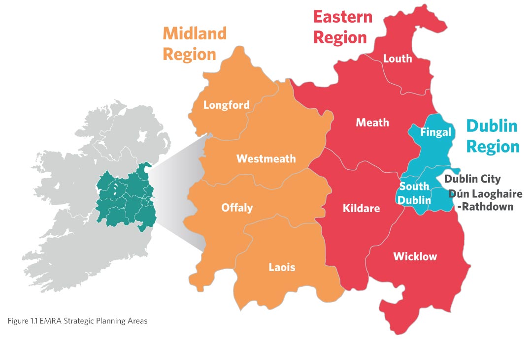
The Eastern and Midlands Regional Assembly (EMRA) prepared the Regional Spatial and Economic Strategy (RSES) in June 2019 for the Eastern and Midlands region; which gives effect to the NPF at regional level. The RSES further endorses the NPF’s principles of consolidation, brownfield development, densification and compact growth. The RSES sets out a new regional plan providing a long-term spatial planning direction for the region in which Dublin is categorised as a Global Gateway in recognition of the international role it plays for the country.
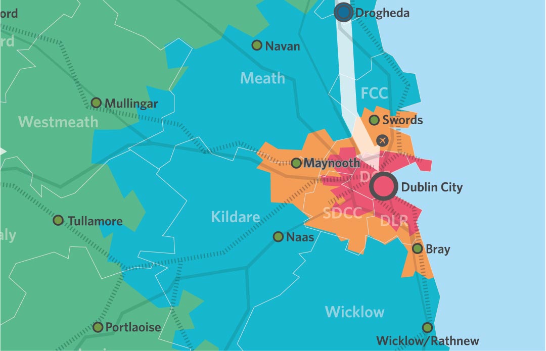
Included in the RSES is the 12-20 year Metropolitan Area Strategic Plan (MASP) for Dublin. The MASP identifies a regional framework which aligns population and employment growth with associated transport and infrastructure investment priorities.
In terms of the future growth of the City, the MASP identifies a number of large-scale strategic areas based on key transport corridors with a capacity to deliver significant development up to the year 2031. These are defined as Strategic Development Areas and Strategic Employment Lands and the Core Strategy must align with these.
The RSES and MASP also support active land management providing guiding principles to deal with the complexities of brownfield and infill sites in the preparation of the Core Strategy. A key element of the RSES is the population allocation provided for Fingal. The Core Strategy aligns with these population figures. This is detailed below.
Draft Transport Strategy for the Greater Dublin Area 2022-2042
The National Transport Authority (NTA) has published for public consultation a draft Transport Strategy for the Greater Dublin Area which seeks to update the current strategy and sets out various proposals for future transport investment for the next 20 years. The new strategy commits fully to the existing transformative public transport projects including BusConnects, DART+ and MetroLink as well as LUAS Finglas, LUAS Lucan, LUAS Poolbeg and LUAS Bray. Within the draft strategy, significant investment is planned for Fingal and particularly as it relates to the corridor connecting Fingal and Dublin City Centre which includes:
- Delivery of MetroLink to Swords and serving Dublin Airport;
- Implementation of the DART Expansion Programme which proposes the provision of high frequency DART services including the electrification of the existing Maynooth and M3 Parkway rail lines and the northern rail line to Drogheda; and
- LUAS Greenline Capacity Enhancement including an extension of LUAS to Finglas.
- Implementation of a Core Bus Network under BusConnects for the Dublin Metropolitan area and throughout the GDA based on bus radial, orbital and regional routes in the GDA.
- Delivery of the metropolitan cycle network set out in the Greater Dublin Area Cycle Network Plan inclusive of key commuter routes and urban greenways on canal, river and coastal corridors.
- Develop a strategic network of regional level bus and rail based Park and Ride facilities in the GDA at appropriate locations where the national road network meets, or is in close proximity to, high capacity bus and rail services.
- Implementation of demand management measures on the M50 motorway to ensure that it retains sufficient capacity to fulfil its strategic functions, including freight movement.
Department of Housing Local Government and Heritage - Section 28 Guidelines
The Department of Housing, Local Government and Heritage (the Department) over the lifetime of different governments has produced various Ministerial Guidelines, known as Section 28 Planning Guidelines, to inform and guide local authorities in carrying out their duties.
The contents of the following Guidelines have informed the Core Strategy and the policies and objectives of the Development Plan:
- Housing Supply Target Methodology for Development Planning, Guidelines for Planning Authorities, December 2020
- Design Standards for New Apartments – Guidelines for Planning Authorities, 2020
- Urban Development and Building Height Guidelines, 2018
- Interim Guidelines for Planning Authorities on Statutory Plans, Renewable Energy and Climate Change, 2017
- Sustainable Residential Developments in Urban Areas, May 2009
- The Planning System and Flood Risk Management – Guidelines for Planning Authorities, 2009
- Appropriate Assessment of Plans and Projects in Irelands – Guidance for Planning Authorities, 2009
- Implementation of the SEA Directive: Guidelines for Regional Authorities and Planning Authorities, 2004
Since 2018, the Planning and Development (Amendment) Act, 2018 introduced a requirement for Planning Authorities to implement Specific Planning Policy Requirements (SPPRs) where they are set out in Guidelines, in the performance of their functions. A statement of compliance with the various Section 28 Ministerial Guidelines and associated SPPRs is contained within Appendix 2.
Of particular interest to this Chapter of the Plan, the Department published the Housing Supply Target Methodology for Development Planning, December 2020, Projected Housing Demand by Local Authority Area 2020 – 2031 ESRI NPF Scenario Housing Supply Target. It contains housing supply targets for each individual local authority. These housing requirement figures, are used as part of the Core Strategy figures, detailed below under Section 2.2.10.
Figure 2.1: Core Strategy Map
Housing For All – a New Housing Plan for Ireland (Sept 2021)
The government’s vision for the housing system over the longer term is to achieve a steady supply of housing in the right locations with economic, social and environmental sustainability built into the system. Launched in September 2021, ‘Housing for All - a New Housing Plan for Ireland’ is the government’s housing plan to 2030. It is a multi-annual, multi-billion euro plan which seeks to improve
Ireland’s housing system and deliver more homes of all types for people with different housing needs. The plan aims to satisfy demand for housing across four tenures – affordable, social, private rental and private ownership. The plan estimates that Ireland will need an average of 33,000 new homes to be provided each year from 2021 to 2030 to meet targets set out for additional households, as outlined in the National Planning Framework. This will include over 10,000 social homes each year over the next five years, with 9,500 of these being new-builds, and an average of 6,000 affordable homes for purchase or rent.
The plan provides four pathways to achieving housing for all supported by actions to be taken by government departments, local authorities, State agencies and others to enable a sustainable housing system. The four pathways to housing for all are: 1. Supporting home ownership and increasing affordability. 2. Eradicating homelessness, increasing social housing delivery and supporting social inclusion. 3. Increasing new housing supply. 4. Addressing vacancy and efficient use of existing stock.
2.2.4 Quantitative Data Underpinning the Core Strategy
This section summarises the key quantitative data used to inform the preparation of the Core Strategy. The two key sets of figures, required to input to the Core Strategy, are population and housing. In this regard, the key data sources are:
- Eastern Midland and Regional Authority: Population Allocation for Fingal County Council (July 2020);
- Department Housing, Local Government and Heritage, Housing Targets for Dublin City Council (December 2020).
The other main sources of quantitative data under this section include an analysis of the Dublin Housing Taskforce (DHTF) Returns for Fingal County Council, which reports on residential planning and construction activity, and the Central Statistics Office (CSO) data on population, housing completions and employment figures. The CSO Census of 2016 (including the most recent CSO annual regional area population projections published August 2020) and the quarterly CSO Local Authority Area New Dwelling Completions also inform the Core Strategy.
2.2.5 Fingal County Council Population Baseline
The population of the Fingal County Council area has increased each inter-censal period between 2006 -2016. The 2006 Census recorded a population figure of 239,992 rising to a recorded population figure of 273,991 (+14.17%) in 2011 with a recorded population figure of 296,020 (+8%) in Census 2016.
Table 2.1: Population Change
|
Year |
Population |
Increase (%) |
|
2006 |
239,992 |
|
|
2011 |
273,991 |
14.17% |
|
2016 |
296,020 |
8.04% |
|
2020 CSO estimate |
311,894 |
5.36% over 4 years |
Source: CSO Census of Population various years
2.2.6 Population Growth Pattern
The CSO’s 2020 population estimate for the Dublin Region was 1,417,700 persons. Fingal County Council’s share of the 2016 Census regional population figure for Dublin was approximately 22%. Assuming the same share for the CSO 2020 estimated regional population figure for Dublin, this gives an estimated population figure of 311,894 for Fingal County Council in April 2020. This indicates an estimated 5% rise in the population of Fingal over a four year period from 2016 through to 2020.
2.2.7 Population – Projections
The adoption of the NPF and RSES now means there are statutory national and regional growth strategies which include population projections based on 2016 census data.
Calculation of the population target parameters for use in Core Strategies comprise a three-stage process based on national and regional provisions and includes; assessment of the RSES targets, application of additional ‘headroom’ as per the National Planning Framework Implementation Roadmap, 2018 (the Roadmap), and incorporation of ‘reallocated growth’ as provided under NPO 68 of the NPF.
1 The RSES
The RSES has set low and high population projections for the region up to 2026 and 2031. This is broken down for each Local Authority and for Fingal County Council; the high population target has been chosen for the Development Plan period.
Table 2.2: RSES Population Projections
|
2016 (CSO) |
2026 Low |
2026 high |
2031 low |
2031 high |
|
296,200 |
327,000 |
333,000 |
340,000 |
349,000 |
2 Application of Headroom
The Roadmap provides scope to Fingal to bring forward the 2031 population figures by up to 25% by 2026. In terms of ‘Headroom’, the Roadmap indicates that an additional 50% growth is already accounted for in the National population targets up to 2026. Thus, the application of 50% growth beyond the Plan period is already accounted for in the targets.
Translating the high RSES projection figures, including the frontloading up to 2026, population projections for the Development Plan period to 2029 is shown below. The remaining 2026 to 2029 figure was calculated on the basis of a pro-rata average year (3 year) of the remaining balance between 2026 and 2031.
Table 2.3: RSES Population Projection for the Fingal County Council Area 2016-2031(adjusted to apply Headroom)
|
2016 (CSO) |
2026 Low |
|
2026 high |
2029 |
|
296,200 |
334,745 |
|
342,245 |
346,298 |
3 National Policy Objective 68 Re-allocated Growth
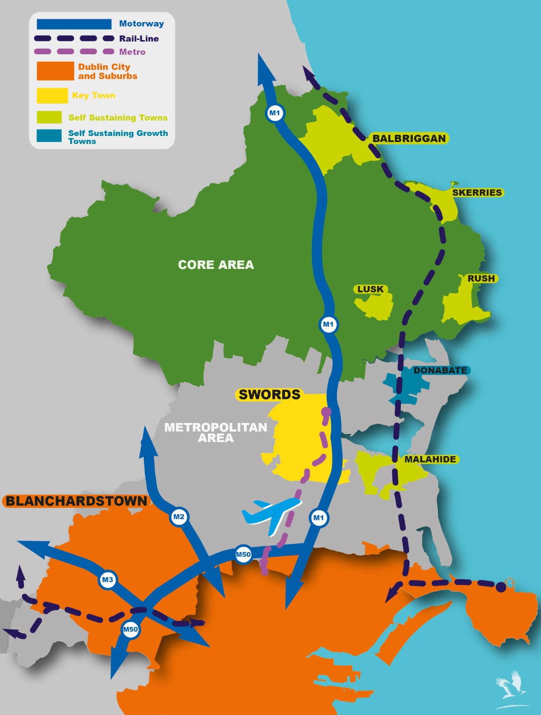
National Policy Objective 68 of the NPF provides that a Metropolitan Area Strategic Plan (MASP) enables up to 20% of the phased population growth targeted in the principal city and suburban area, to be accommodated in the wider metropolitan area. The Dublin MASP, as set out in the RSES, further elaborates upon NPO 68 stating that the provision to allow for the transfer to other settlements shall apply only to three Metropolitan 'Key Towns', namely Bray, Maynooth and Swords. In accordance with NPO 68, and as approved by the Eastern and Midland Regional Assembly, an additional 20,000 population was allocated to Swords.
Table 2.4: RSES Population Projection for the Fingal County Council Area 2016-2031(adjusted to comply with NPO 68)
|
2016 (CSO) |
2026 Low |
2026 high |
2031 low |
2031 high (adjusted) |
|
296,200 |
334,745 |
342,245 |
340,000 |
369,000 |
The Fingal Development Plan runs from 2023 until 2029. The above figures have been used to extrapolate figures aligning with the plan period. The adjusted population for the Fingal County Council area for the year 2029 is 334,160 (low) to 359,290 (high) persons.
Table 2.5: RESE Population Projections, adjusted to 2029
|
2016 (CSO) |
2026 Low |
2026 high |
2029 |
|
296,200 |
334,745 |
342,245 |
359,000 |
2.2.8 Fingal County Council – Housing Baseline
In 2016, there were 104,851 residential units within the Fingal County Council area. Of this figure, 5,233 units were vacant representing c. 5%. This rate of vacancy falls within the normal range of 2.5% to 6.5% which is considered to be normal in a properly functioning housing market.
2.2.9 Housing Delivery
The monitoring of construction and planning activity is an invaluable tool to ensure a clear understanding of housing delivery and the type of planning permission and commencements at different locations across the County.
The Housing Taskforce (HTF) tracks the quantum of residential development for 10 no. or more units in the four Dublin Local Authorities on a quarterly basis, since 2016. It provides detailed insight into planning and construction activity in the residential sector and the inter-relationship between same. The DHTF figures provide a ‘snapshot’ in time that includes all extant permissions that are ‘live’ at the time the DHTF return is prepared and published.
According to Dublin Housing Task Force (DHTF) returns Q1 2017 – Q2 2021, the numbers of new dwellings completed in Fingal since the adoption of the last Development Plan (from Q1 2017 until Q2 2021) was 7,171 units. Assuming the same average return per quarter (398 units) until the end of the Development Plan period, the completions within the full six-year period of the last plan to Q1 2023 is expected to realise approximately 9,960 units.
Table 2.6 provides the most recent return at time of writing (Q2, 2021 illustrates the rising volume of permissions and construction activity that has taken place over the past number of years.
To date there have been 30 no. Strategic Housing Development (SHD) applications made for the Fingal area, with a total of 9,242 units proposed in these applications. Within these applications 20 no. SHD’s (over 17 sites – 4,499 units) have been approved and there are currently 3 no. live applications (2,687 units) where a decision has not yet issued (end Q2 2021). The number of housing units completed at this time is 141 and a further 223 units are under construction. The deliverability of SHDs will form part of the Core Strategy monitoring process.
Table 2.6: Housing Task Force Returns Q2, 2021
|
No of sites with planning permission in Tier 1 |
128 |
|
No. of units with planning permission |
14,310 |
|
Active sites |
72 sites |
|
No. of units under construction |
2,536 units |
|
No. of units completed and occupied in 12 month period to end Q2 2021 |
1,358 units |
|
Newly Complete / Occupied in Q2 2021 |
278 units |
Table 2.7: Fingal County Council DHTF Returns Q2 2021
|
Planning Application Stage (Q2 2021) |
No. of Residential Units |
|
Extant Planning Permissions (permitted) |
14,130 |
|
Pending Planning applications (proposed) |
3,077 |
Source: DHTF Returns
As of Q2 2021, there were 14,130 residential units with extant permissions across the County and there were a further 3,077 proposed residential units pending a planning decision. Current indicators show that construction activity has successfully re-opened and it is expected that future DHTF returns for 2021 and2022 will demonstrate continued strong growth in housing construction.
Table 2.8: Fingal County Council DHTF Returns Q2 2021- Construction Site Activity
|
Sites |
No. of sites |
No. of residential units |
|
Active site |
72 |
8,603 |
|
Non active sites |
56 |
5,707 |
|
Total |
128 |
14,130 |
Source: Source: DHTF Returns
At the end of Q2 2021, permission for 5,707 residential units has not yet been activated. The figures indicate that 43.75% of sites with planning have not commenced. This could reflect a range of factors including impact of Covid 19, market forces, permission sought to increase land value for re-sale, issues with sourcing the appropriate level of funding to commence construction, capacity of construction industry, etc.
It is reasonable to assume that Fingal County Council will have, on an ongoing basis, a quantum of sites that are suitable for residential development and that have the benefit of planning permission, which may not be brought forward for development within the lifetime of the Plan, or sites which may not come forward for planning at all.
2.2.10 Housing Supply Targets
The Department of Housing, Local Government and Heritage issued Section 28 Guidelines - Projected Housing Demand by Local Authority Area 2020 – 2031 ESRI NPF Scenario Housing Supply Target of S28 Housing Supply Target Methodology for Development Planning, December 2020 - to provide Planning Authorities with the figures and methodology to incorporate national and regional population and housing projections into their statutory functions.
The methodology utilises research undertaken by the Economic and Social Research Institute – ‘Regional Demographics and Structural Housing Demand at a County Level’, Research Series, Number 111, Economic and Social Research Institute (ESRI), December 2020. The guidelines are to be applied by each Planning Authority to assist in ensuring that their Development Plan is prepared to be consistent with the National Planning Framework and relevant Regional Spatial and Economic Strategy. To support each Planning Authority in applying the methodology, comprehensive background data necessary for the methodology calculation in Table 1 of the Guidelines, were issued to each Planning Authority in January 2021. Using this methodology, the projected households for Fingal from the year 2023 to 2029 are set out below.
The table below applies the approach prescribed to estimate projected housing demand for Fingal. The results of this approach identifies the need for 22,132 residential units from 2017 through to 2029 within the Fingal County Council area, which must then be refined to the Development Plan period, following the prescribed methodology. Estimated homelessness and unmet demand1 (4,073) is added to this need; and the projected volume of housing delivered from 2017 to 2023 (9,960) is subtracted. Using this calculation, the Housing Demand for the years 2023 to 2029, the relevant Development Plan period, is approximately 16,245 residential units for the six-year period.
Table 2.9: Projected Housing Demand for Fingal County Council Area 2023 – 2029
|
Table 2.9: Fingal County Council |
Total Households |
Number of Relevant Years |
Annual Average |
|
|
A |
ESRI NPF scenario projected new household demand 2017 to end Q1 2029 |
22,132 |
12.25 |
1,771 |
|
B |
Actual new housing supply 2017 to end Q1 2023 (actualto Q2 2021 and estimated Q3 2021 – Q1 2023) |
9,960 |
6 |
1,660 |
|
C |
Homeless households and unmet demand |
4,073 |
- |
- |
|
D |
Plan Housing Demand = Total (A- B+C), (Projected ESRI NPF demand – new completions) + Unmet demand |
16,245 |
6 |
2,708 |
Summary
Based on the population targets and calculated housing need set out within national and regional planning policy, guidelines and prescribed methodology, the Development Plan must accommodate between 37,980 – 62,980 additional persons up to an overall population target of between 334,000 (low) to 359,000 (high) persons by 2029.
The housing demand calculated sets a requirement for the Plan to provide for approximately 16,245 housing units between 2023 and 2029.
The combination of the additional housing units required alongside the population growth indicates an anticipated decrease in average household size for the overall County. By 2029, with a total population of 359,000 persons and a total housing stock of 131,056 (this includes 2016 figure, 2017 – 2023 figure and HST figure) houses, the household size will be an average of 2.73 per house. This is a reduction from 3.03 in 2016 and is consistent with the downward national trend of household size, and the trends outlined in the National Planning Framework which show house size falling from 2.75 in 2016 to 2.5 in 2040.
It is noted that there is variation above and below the household size depending on the typologies of extant planning permission, as well as demographic and household composition in each area whether urban or rural. This average household size has informed the population distribution as part of the Settlement Strategy, informed by the Core Strategy, as set out in the next section.
2.2.11 The Core Strategy
This section sets out the key elements that comprise the Core Strategy including an assessment of the location and quantum of appropriately zoned lands available to accommodate the population and housing targets for the County, detailed above. It is a central function that the Core Strategy demonstrates that there is sufficient zoned suitable land to meet the requirements of the projected targets.
This Core Strategy section has been prepared in the context of the preceding sections of this Chapter.
Climate Change
Central to the entire Core Strategy is the clear purpose of driving forward the steps necessary that deliver climate action. Fingal County Council is uniquely placed to provide for new housing in locations that fully support sustainable forms of development and allow large numbers of people live, move and work in a way that limits their carbon footprint. Providing for a critical mass along public transport corridors, creates the opportunity for people to engage with a wide range of services and social opportunities as well as a work location, all within distances that are well served by high quality public transport, premium cycle routes and attractive public realm. This Plan seeks to implement a Core Strategy that continues to build mixed use communities at appropriate locations across the County that can sustain and grow a low carbon society (see Chapter 5 for greater detail.)
Land Capacity Assessment
Fingal County Council covers an area of over 450 square kilometers, with just over 43,339 hectares of land zoned (the remaining unzoned lands comprises road carriageways, footpaths and rail corridors). The c. 43,000 hectares of zoned land is divided between the 22 zoning objectives, seven of which can provide for residential use, namely Local Centre (LC), Major Town Centre (MC), Metro Economic Corridor (MEC), Residential Area (RA), Residential (RS), Rural Village (RV) and Town and District Centre (TC). These seven zoning objectives, in total, make up 4,939 ha of the overall zoned landbank.
An urban capacity assessment was carried out on behalf of the Planning Department to calculate the yield of undeveloped land, specifically for the 31 designated settlements identified in the ‘Fingal Settlement Hierarchy’ in the current Fingal Development Plan 2017 – 2023.
Of this c.4,900 ha of land zoned for residential or mixed (including residential) uses; it has been estimated that there are approximately 1,250 hectares available to develop during this development plan cycle which can provide approximately 41,500 residential units. Note, this includes the long term strategic reserves at Lissenhall and Dunsink.
The analysis undertaken demonstrates that Fingal County Council has excess capacity to accommodate the required need of 16,245 residential units over the plan period within its administrative area. The breakdown of this available land and associated housing capacity is detailed below.
Capacity of Zoned Lands Fingal Development Plan 2017 – 2023
From the consideration of density standards on a site-by-site basis, the available land indicates a potential aggregate yield of circa 35,200 residential units from all settlements in Fingal. Note, this includes the long-term strategic lands at Lissenhall, for which a capacity of 7,000 is given.
Whilst due consideration has been given to application of appropriate density standards, the residential yield should be considered as an approximate figure given that there are many and different variables, that can affect actual and final density considerations including not least, the wide variation within current density standards, and that density can be influenced by detailed design matters (and potential infrastructural constraints).
That said, the approach for this assessment has been to pursue the higher bands of residential density appropriate to the position of the settlement in the County settlement hierarchy and, where it is considered that the site and its context is suitable to accommodate increased residential density. Conversely, even in larger and designated growth towns, there are site-specific instances (albeit limited), where lower density is applied in order to apply logical reasonableness to the analysis, where the pursuit of higher density is not considered appropriate from a ‘proper planning’ perspective. For example, opportunities for residential infill in large or growth settlements where the immediate urban environment is defined by close proximity to compact low-rise development, were considered better suited to lower density to facilitate effective assimilation (which also in turn, allows for diversity in tenure and in housing stock).
Excluding those lands identified for strategic long-term development within Lissenhall in Swords, the analysis estimates a potential for 28,204 units on 889 hectares of developable land within the lifetime of the Development Plan period. Zoned land with extant permission not commenced (circa 6,400 units) has been recognised.
The potential yield of undeveloped land in each settlement is contained below.
Table 2.10: Remaining Zoned Residential Capacity from Fingal Development Plan 2017 – 2023
|
Settlement Type |
Settlement Name |
|
Land Availability (Ha) |
Residential Yield |
|---|---|---|---|---|
|
Metropolitan Area |
||||
|
Dublin City and Suburbs Consolidation Area |
Blanchardstown |
Includes Castleknock, Clonsilla, Mulhuddart, Ongar, Hollystown,Tyrellstown, Dunsink |
150 |
5,742 |
|
Ballydoyle/Sutton |
|
13 |
706 |
|
|
Howth |
|
14 |
209 |
|
|
Other Settlements |
Includes Santry, Ballymun, Balgriffin, Belcamp, Charlestown and Meakstown. |
57 |
1,970 |
|
|
Key Town |
Swords |
|
329 |
12,875 |
|
Self Sustaining Growth Town |
Donabate |
Includes Portrane |
111 |
2,945 |
|
Self Sustaining Town |
Malahide |
|
37 |
944 |
|
Portmarnock |
29 |
934 |
||
|
Towns and Villages |
Towns and Villages |
Includes Coolquay, Kinsealy, Rivermeade & Rowlestown |
89 |
999 |
|
Core Area |
||||
|
Self Sustaining Towns |
Balbriggan |
Includes Balrothery |
116 |
4,151 |
|
Rush |
|
43 |
1,631 |
|
|
Lusk |
|
27 |
760 |
|
|
Skerries |
Includes Loughshinny |
21 |
596 |
|
|
Other Core Towns and Villages |
Towns and Villages |
Includes Ballyboughal, Oldtown, Ballymadun, Garristown, Nail, Balscadden |
80 |
745 |
|
Rural |
||||
|
Total |
|
|
1,115 |
35,204 |
The analysis of the Urban Capacity Study shows:
- 77% of residential yield provided within the ‘Metropolitan Area’ (23% in Core) Note: this includes the long-term strategic reserve of Lissenhall
- Residential density standard of 30.5uph in the County (39uph in Metropolitan area)
- Higher residential density bands applied to larger growth settlements
- 95% of urban capacity land defined as ‘greenfield’ land
- 0.55% of urban capacity land defined as either ‘vacant/derelict or brownfield’
Land Capacity and Zoning Requirements
Excluding lands identified as the strategic long-term reserve at Lissenhall there is potential for c. 28,000 units on 889 hectares of developable land within the lifetime of the Development Plan
period.
As part of the preparation of this draft Development Plan, a detailed analysis of the zoning maps was undertaken to identify lands that required changes to zonings under four main categories.
These included:
- Zoning of lands at Dunsink as part of the Long-Term Strategic Reserve
- The need to update the zoning where development is now complete;
- The need to amend small scale anomalies and discrepancies and
- The need to amend some open space and educational uses to more appropriate zoning objectives.
Taking into account the number of reasons zoning changes have been made (as outlined above); only a small portion of these amendments offer potential housing capacity, i.e. a significant portion relate to completions of new developments, that is, changes from RA to RS.
Summary - Total Land Capacity and Zoning Requirements
Table 2.12 summarises and shows the location of the potential capacity of zoned lands within the Draft Plan; combining the existing zoned areas with new potential zonings (including the Long-Term Strategic Reserve at Dunsink). There is zoned capacity for approximately 41,500 units on approximately 1,250 hectares of developable land within the lifetime of the Development Plan.
Table 2.12: Total Capacity of Zoned Lands 2023 – 2029
|
Zoned Lands |
Estimated Capacity |
Area (HA) |
|
Lands Zoned at 2017 – 2023 Plan |
28,204 |
889 |
|
Minus Other Lands Changes |
589 |
21 |
|
Current zoned total |
27,615 | 868 |
|
Potential lands at Dunsink (Long Term Strategic |
7,000 |
164 |
|
Reserve |
|
|
|
Potential Long Term Strategic Reserve at Lissenhall |
7,000 |
225.5 |
|
Potential total |
41,615 | 1,257 |
Based on this housing capacity, there is evidently sufficient zoned land to meet the needs ofthe population and housing targets set by the Ministerial Guidelines and the NPF. In addition to this, there are also significant Long Term Strategic Reserve lands, zoned for housing/mixed use that have potential to deliver additional housing beyond the 6 year life of this Plan. For the purpose of clarity, these lands (Lissenhall and Dunsink) are included in the table as potential lands. These two large tracts of land are currently proposed for new urban neighbourhoods beyond the 6 year lifetime of this Plan – see Section 2.2.12 for more detail.
2.2.12 Strategic Long-Term Reserve
Two major tracts of land have been identified as Strategic Long Term Reserve lands. These are key development sites that are characterised by:
- Their potential for significant residential development to be delivered over a timescale greater than a single six-year development plan period
- Their significant scale – several thousand new homes as a new urban neighbourhood.
- A requirement to be aligned and supported by significant water services, transport and other infrastructural investment.
The extended timescale needed to deliver such infrastructure requires certainty in terms of zoning status to ensure such long-term planning and investment.
Lissenhall
Given the MetroLink route will extend into the lands at Lissenhall, the zoning must be appropriate for the area. Furthermore, a substantial portion of these lands will be within 1km of the agreed Estuary Stop. Lissenhall is an expansive, low-lying, rural landscape comprising approximately 240 hectares (of which 225.5 is zoned for development). The area, in broad terms, is bounded by the M1 and R132 to the east, the Broadmeadow River to the south and south west, and the proposed route of the Swords Western Ring Road to the north. These lands are adjacent to the M1 and Belfast-Dublin corridor. By identifying Lissenhall as a key future development area, the Council is seeking to maximise the opportunities created by the delivery of this key piece of strategic infrastructure in accordance with best planning practice and the principles of sustainable development. The development of the area following the sequential development of the existing Swords envelope, is also consistent with the Council’s long term strategic vision for Swords to develop as a sustainable city. It is envisaged that this area could accommodate the development of a significant mixed-use urban district providing for a significant level of employment in addition to approximately 6,000 – 7,000 residential units. A statutory land use plan will be prepared for these lands to provide a framework for development.
Dunsink
The strategic location and development potential of lands at Dunsink is recognised within the RSES and this Development Plan. This land area comprises 435 hectares and is located at the south-western fringe of Fingal within the M50. The lands are characterised by their current use for predominantly agricultural and recreational amenity purposes. The Royal Canal and Tolka River Valley run to the south of the lands while Elm Green Golf Course covers a large part of the western portion of the site, with the closed landfill located to the north.
The area also includes the Dunsink Observatory which operates as part of the Astronomy & Astrophysics Section of the Dublin Institute for Advanced Studies (DIAS). Dunsink Observatory has been a centre for astronomical research and public engagement in Ireland since its foundation in 1785, and has been home to many of Ireland’s most famous scientists, including Sir William Rowan Hamilton. This unique scientific and cultural feature is an asset for the future development of the area. This Plan seeks to provide the Hamilton Way, a pedestrian link from the Observatory to Ashtown Train Station.
Located only six kilometres from Dublin City Centre, this area provides a unique opportunity to significantly consolidate the Dublin Gateway in a sustainable manner underpinned by high quality public transport given the site benefits from close proximity to the existing heavy rail network at Ashtown and the proposed extension to the Luas to Finglas. The closed landfill offers an opportunity for a regional park and will be a key part of the amenity facilities of any future urban neighbourhood.
The recently carried out Dunsink Feasibility Study envisaged that the lands could facilitate approximately 7,000 residential units. While recognising these lands as a potential strategic landbank for the County, it is acknowledged that this land bank will require Strategic Development Zone (SDZ) status, or other relevant planning-related designation.
The scale and extent of both areas is significant and has great potential to provide high quality new housing and commercial development within the County. However, there are significant challenges in delivering such lands including provision of physical and social infrastructure, fragmented land ownership and the challenges of implementation. It is likely that the regeneration of these lands will be over a longer time frame than the Plan and the overall impact on the Core Strategy for this Plan is non-existent.
NPF Tiered Approach and Phasing
The amount of zoned land is in excess of the acceptable 20 – 25% surplus identified in the Draft Development Plan Guidelines, published August 2021.
Given the surplus capacity identified, Fingal County Council have considered the Tiered Approach to the zoning of land. The NPF tiered approach under NPO 72a requires a local authority to differentiate between zoned lands that are serviced and zoned lands that are serviceable within the life of the Plan. Fingal County Council is exceptional in that the entire plan area is serviced and no fundamental constraints were identified by Irish Water. Whilst there may be local infrastructural needs and upgrades needed for certain sites, all lands within the County are serviced and are connected to the public water systems. Furthermore, almost all lands are located proximate to existing and planned public transport corridors. All lands are located alongside existing public road routes and an extensive network of pedestrian and cycle routes are underway.
The NPF and the draft Development Plan Guidelines outline that Tier 1 lands comprises lands that are able to connect to existing development services, i.e. road and footpath access including public lighting, foul sewer drainage, surface water drainage and water supply, for which there is service capacity available, and can therefore accommodate new development. These lands will generally be positioned within the existing built-up footprint of a settlement or contiguous to existing developed lands.
It is considered all the capacity lands in Fingal are Tier 1 – as they are zoned, serviced and available.
It is noted that the NPF specifically discusses the prioritising of development lands and states that there are many other planning considerations relevant to land zoning beyond the provision of basic enabling infrastructure including overall planned levels of growth, location, suitability for the type of development envisaged, availability of and proximity to amenities, schools, shops or employment, accessibility to transport services etc.
Weighing up these factors, together with the availability of infrastructure, assisted Fingal in determining the order of priority to deliver planned growth and development.
Analysis
Having established that all existing lands zoned within Fingal are serviced and located alongside existing or planned public transport corridors and come within the definition of Tier 1, it is reasonable to consider other factors in order to prioritise lands to deliver planned growth and development in line with the NPF.
Consideration was given to the available lands in the context of the sequential approach and the ambitious goal of the NPF of 50% of housing to be provided within or contiguous to the built-up area of Dublin City and suburbs and 30% of housing for other metropolitan settlements.
Analysis shows that the existing capacity of the zoned Fingal lands is 72% within the Metropolitan Area and 27% in the Core. 31% of the capacity is within the Dublin City and Suburbs. Notwithstanding this being below the NPF goal of 50%, it is reflective of the historical approach to zoning in Fingal. The current approach advocates moving towards the NPF goal of 50% within the City and Suburbs. Furthermore, the approach of the Urban Capacity Study has been to assign densities which are reasonable and appropriate to the position of the settlement in the County’s Settlement Hierarchy. However, there are site-specific instances, where lower density is applied in order to apply reasonableness to the analysis and where the pursuit of higher density is not considered appropriate from a ‘proper planning’ perspective. For example, opportunities for residential infill in large or growth settlements where the immediate urban environment is defined by close proximity to compact low- rise development, were considered better suited to lower density to facilitate effective assimilation (which also in turn, allows for diversity in tenure and in housing stock).
Fingal County Council will continue to pursue the goals of the NPF of consolidation of Dublin City through the compact development of the Dublin City and Suburbs area within Fingal.
The other Metropolitan towns of Swords, Donabate, Malahide and Portmarnock and the villages account for c. 41% which is above the 30% goal.
It is noted that half (52%) of this is allocated to Swords which is designated as a Key Town in the RSES where additional growth has been allocated in accordance with NPO 68 of the National Planning Framework and the MASP. NPO 68 of the NPF states:
A Metropolitan Area Strategic Plan may enable up to 20% of the phased population growth targeted in the principal city and suburban area, to be accommodated in the wider metropolitan area, i.e. outside the city and suburbs or contiguous zoned area, in addition to growth identified for the Metropolitan area. This will be subject to:
- Any relocated growth being in the form of compact development, such as infill or a sustainable urban extension,
- Any relocated growth being served by high capacity public transport and/or related to significant employment provision,
- National Policy Objective 9, as set out in Chapter 4 of the NPF.
The Regional Spatial and Economic Strategy provides further elaboration as it states;
‘This shall apply only to the three Metropolitan Key Towns in the MASP, namely Bray, Maynooth and Swords, and only if they can demonstrate compact growth on high capacity or planning existing public transport corridors’.
The designation of Swords as a Key Town within the Eastern and Midland Region and as outlined in the RSES for the area is aligned with Fingal’s long-term approach for the development of Swords as the County Town and for its growth to a city of a sizable scale. Accordingly, the designation of 21% of the overall units to Swords is appropriate and in accordance with the key priorities of compact growth and enhanced public realm in the town centre along with the planned sequential development of Swords. This approach is necessary in line with this strategic vision and ongoing investment in the town.
The allocation of c. 20% of the units to the other towns and villages within the Metropolitan area works towards the RSES target of 30% for other metropolitan settlements. Again, on consideration of the zoned lands within the Metropolitan towns and villages and the existing growth rates, it is considered that this allocation is appropriate for the towns and villages.
Lastly, the Core Region accounts for c. 28% of the capacity. The RSES outlines the growth enablers for this area. Part of this to promote continued growth at sustainable rates, while providing for increased employment and improved local economies, services and functions to allow towns to become more self-sustaining and to create the quality of life to attract investment. In order to facilitate the achievement of compact growth in the Core Region, a target of 30% of all new homes should be within the existing built up area of settlements. The capacity for the Core Region is aligned with the target.
Further analysis was carried out to assess existing zoned lands in respect of their ability to contribute towards National Strategic Outcomes relating to compact growth, sustainable mobility, climate action and a transition to a low carbon and climate resilient society. The result of this indicates that generally, all lands currently zoned are capable of delivering residential development within the County and contributing in a positive manner to the achievement of the above NSOs.
Consideration is also given to ensuring that the delivery of housing to meet the needs of current and future population in line with national targets during the course of the plan period can be sustainably achieved. In this regard the balance between the deliverability of units and avoiding an overly rigid identification of specific capacity lands forms a key part of the Core Strategy. The approach taken considers the need to promote compact growth in a balanced way within each town and village according to its role and function within the settlement hierarchy.
The Council is actively engaged with social and affordable housing delivery and has a strong supply pipeline which will be delivered over the Development Plan period and will provide for a significant proportion of the annual housing targets for the County. However, in terms of deliverability from a private development perspective, the following factors have been considered:
- 72% of the allocated unit growth is within the Metropolitan Area, and 28% within the Core
- 43% of the allocated growth within the Metropolitan Ares is within Dublin City and Suburbs and 30% within the Key Town of Swords.
- The housing data and trends within the County indicate that approximately 43% of sites with permission are activated at any given time while the remainder may take time to commence, based on a range of factors (e.g. raising of funding, potential market changes) or that permissions may not be implemented at all during their lifetime.
- Larger developments (SHDs) comprise a significant element of permitted units throughout the County and delivery has been limited to date.
This presents a challenge which the Council is closely monitoring and in recognition of the above, a flexible approach to provide for delivery has been incorporated into the Plan. This will ensure an adequate supply of suitable lands come forward to compliment the Council’s supply pipeline and achieve the housing supply targets.
Therefore, while the County has an excess of zoned land than that required to deliver the supply targets this is considered necessary to facilitate a choice in sites that come forward recognising that not all sites may be available within the plan period.
Regard must be had to the historical trends for housing delivery as detailed above and the fact that there are significant complexities in delivering housing including issues such as economic viability, site assembly and site ownership, funding, timescales for delivering the necessary physical infrastructure and the nature of speculative land management.
Since the adoption of the Development Plan in early 2017, activity in the housing sector in Fingal has generally (apart from a Covid slowdown in 2020) been growing in a positive manner and at the end of June 2021, there are 72 active sites with 2,500 homes under construction. The bulk of this construction activity is taking place in the ‘Dublin City and Suburbs’, and ‘Metropolitan’ area and is in areas with a framework for growth.
Fingal has employed a number of policy responses to facilitate housing development, namely the adoption of Local Area Plans (LAPs) and Masterplans across the County. The LAP’s and Masterplans provide a framework for development. These set out where Fingal’s priorities for growth are and provide a development framework and phasing arrangements which will ensure the delivery of the required social and physical infrastructure in an appropriate manner. In addition, the preparation of these Plans has involved significant local consultation and the engagement of Elected Members and give a degree of certainty to those involved in the development of their areas. Furthermore, as part of this approach to facilitate housing development, Fingal County Council has applied for and has been successful in seeking funding through the Local Infrastructure Housing Activation Fund (LIHAF) and the Serviced Site Fund.
This policy response is shown to be successful to date. The main areas of construction activity, i.e. Hansfield, Blanchardstown, Swords, Baldoyle, Portmarnock, Donabate and Santry are the areas with the Strategic Development Zone, Local Area Plans and Masterplans and also, where construction and SHD activity is taking place. This clearly shows how the development of Fingal is in line with the National and Regional policy regarding consolidation of development within Dublin City and Suburbs, and within the development boundary of existing towns and urban areas and along public transport corridors.
While the particular LAPs and Masterplans include phasing arrangements which ensure the rate of growth is aligned with the provision of social and physical infrastructure and the growth targets of the RSES, the provision of such plans, will naturally result in a phasing of land, i.e. those with a framework will be available for development before those without.
Fingal’s location within the region and the location of the zoned available land along existing and proposed high capacity public transport corridors and its ability to provide a steady stream of housing must be considered a positive attribute in current circumstances.
Consideration was given to the phasing of land within Fingal, however, this would result in zoned, serviced lands being unavailable for development and in itself, would be contrary to the overarching national and regional objectives to provide housing in appropriate locations at an appropriate scale. Furthermore, given the ambitious targets of Housing for All and the current housing supply crisis, it is appropriate to continue with the Active Land Management objectives of the Council.
The analysis carried out identified that lands are serviced and have the potential to contribute towards sustainable development, ensuring that any obstacles to delivery in one area or site can be overcome by provision within another. This ensures sufficient lands are available to meet the supply targets identified.
Key to ensuring this flexible approach and alignment with National and Regional Planning Policy is the Council’s Active Land Management objective to monitor construction and planning activity throughout the County at a settlement level as outlined above and under Section 2.4 below.
Housing delivery within the Metropolitan Area and to some extent towns in the Core Area indicate that Fingal is well positioned to facilitate the right quantity of appropriate housing in the right locations.
It is Fingal’s priority, and has been for a significant period of time and over successive Development Plans, to form effective and innovative approaches to mobilise development to create housing and quality urban neighbourhoods. Consequently, any development undertaken in the County is positioned against national, regional and local policies and objectives. Therefore, Ireland 2040, Housing for All, the Regional Spatial and Economic Strategy, Fingal Development Plan, the Urban and Rural Regeneration and Development Funds, and other such policies and programmes set the context for future development.
Having regard to the history of housing delivery in Fingal in locations either within Dublin City and Suburbs, within Swords Key Town and proximate to high quality public transport in the Metropolitan Area, and to a lesser extent, in similar well-served locations within the Core area, Fingal County Council aims to continue to effectively manage sustainable growth in the settlement typologies within the County.
The Core Strategy figures for each settlement serve as a benchmark for monitoring to ensure compliance with National and Regional figures.
Core Strategy – 2023 – 2029 Fingal Development Plan
Table 2.14 sets out the Core Strategy for this Development Plan.
|
Settlement Type |
Settlement Name |
CSO 2016 Population |
Estimated 2023 Population |
Estimated 2029 Population |
Extant Permission |
Land Availability (Ha) |
Residential Yield |
|
|
Metropolitian Area |
|
|
|
|
|
|
|
|
|
Dublin City and Suburbs Consolidation Area |
Blanchardstown |
includes Castleknock, Clonsilla, Mulhuddart, Ongar, Hollystown, Tyrrelstown, Dunsink |
107,931 |
124,121 |
138,098 |
1,745 |
150 |
5,742 |
|
Baldoyle/Sutton |
|
13,402 |
14,474 |
15,335 |
675 |
13 |
706 |
|
|
Howth |
|
8,294 |
8,875 |
9,336 |
704 |
14 |
209 |
|
|
Other Settlements |
includes Santry, Ballymun, Balgriffin, Belcamp, Charlestown & Meakstown |
15,211 |
16,428 |
17,405 |
467 |
57 |
1,970 |
|
|
Key Town |
Swords |
|
47,120 |
54,188 |
64,453 |
899 |
104 |
5,875 |
|
Self Sustaining Growth Town |
Donabate |
includes Portrane |
9,607 |
10,568 |
9,895 |
324 |
93 |
2,529 |
|
Self Sustaining Town |
Malahide Portmarnock |
|
17,053 9,549 |
17,906 10,408 |
18,568 11,106 |
278 185 |
38 29 |
994 934 |
|
Towns & Villages |
Towns and Villages |
includes Coolquay, Kinsealy, Rivermeade & Rowlestown |
3,482 |
3,656 |
3,791 |
325 |
89 |
999 |
|
Core Area |
||||||||
|
Self Sustaining Towns |
Balbriggan |
includes Balrothery |
24,027 |
25,949 |
27,492 |
81 |
116 |
4,151 |
|
Rush |
|
10,359 |
10,877 |
11,279 |
284 |
43 |
1,631 |
|
|
Lusk |
|
8,353 |
8,771 |
9,095 |
124 |
27 |
760 |
|
|
Skerries |
includes Loughshinny |
10,266 |
10,779 |
11,178 |
180 |
15 |
373 | |
|
Other Core Towns and Villages |
Towns and Villages |
includes Ballyboughal, Oldtown, Ballymadun, Garristown, Naul, Balscadden |
4,439 |
4,617 |
4,753 |
90 |
80 |
745 |
|
Rural |
|
|
7,121 |
7,263 |
8,650 |
|
|
|
|
Total |
|
296,214 |
328,879 |
360,432 |
6,361 |
868 | 27,615 | |
In line with the above, the Core Strategy figures set out in Table 2.14 factor in sites with planning permission but not commenced. The Strategic Long Term Reserve lands are not included in this table.
This has been guided by the housing capacity of existing undeveloped zoned land in Fingal, the needs for Housing units by the Ministerial Guidelines and other Planning policy documents set out in the earlier sections of this Chapter.
Policy CSP1 Core Strategy
Promote and facilitate housing and population growth in accordance with the overarching Core Strategy to meet the needs of current and future citizens of Fingal.
Policy CSP2 Compact Growth and Regeneration
Support the implementation of and promote development consistent with the National Strategic Outcome of Compact Growth as outlined in the NPF and the Regional Strategic Outcome of Compact Growth and Regeneration as set out in the RSES.
Policy CSP3 Strategic Development Areas and Corridors
Support the economic development of Fingal in line with the policies and objectives stipulated in the National Planning Framework and the Regional Spatial and Economic Strategy and utilise active land measures such as provision of LAP's and masterplans across the County as part of the development approach for Strategic Development Areas and Corridors.
Policy CSP4 Sequential Development
Promote the sequential development of serviceable lands in accordance with the tiered approach to land zoning outlined in the NPF, the RSES and MASP and ensure co-ordination with other neighbouring planning authorities where strategic development corridors traverse county boundaries.
Policy CSP5 Key Enabling Infrastructure
Identify and support the provision of key enabling infrastructure at strategic development sites in Fingal County, as outlined in the MASP, to facilitate their release for development during the lifetime of the Development Plan.
Objective CSO1 Sufficient Zoned Land
Ensure that sufficient zoned land is available to satisfy the housing and population requirements of the County, as set out under the Ministerial Guidelines for Housing Supply and the Regional Spatial and Economic Strategy, over the lifetime of the Plan
Objective CSO2 Monitoring Process for Housing Delivery
Implement a robust monitoring process for all housing delivery for each settlement within the County to allow for ongoing assessment of delivery targets whilst ensuring overdevelopment does not occur in any particular area and to ensure that the delivery of necessary infrastructure is timely to ensure the sustainability of communities.
Objective CSO3 Delivery of Housing Units
Monitor the delivery of housing units to ensure general compliance with the Core Strategy and housing supply targets for the County and to inform any required redistribution.
Objective CSO4 Database for Residential Zoned Land
Create and maintain a database of land zoned for residential development that has not yet been developed including, where available, information on why this land has not been developed so as to inform future zoning and de-zoning decisions
Objective CSO5 Phased Development
Ensure the phased development of new housing areas in tandem with the delivery of physical and social infrastructure provision as identified within Local Area Plans or Masterplans, as informed by assessments carried out by the Planning Authority.
Objective CSO6 Enabling Infrastructure
Identify and support the provision of key enabling infrastructure at strategic sites in Fingal County to facilitate their release for development in response to the current housing crisis
2.3 Housing Strategy and HNDA Housing Strategy
A Housing Strategy has been prepared to meet statutory requirements set out under the Planning and Development Act 2000 (as amended) and in particular, Part V of said Act. The Act requires each planning authority to prepare a housing strategy which will cover the period of its Development Plan. The Housing Strategy forms an integral part of the Development Plan by incorporating national and regional housing policies and housing demand and supply requirements at a local level. The Housing Strategy is set out in Appendix 1.
Following the publication of National and Regional level planning policy, the Housing Strategy is now supported by an evidence-based Housing Need Demand Assessment (HNDA).
2.3.1 Housing Need Demand Assessment
HNDA is a tool that is aimed at assisting local authorities to develop long term strategic views of housing need across all tenures, and to provide a robust evidence base to inform policies around housing and to support the preparation of housing strategies. HNDAs are designed to give broad, long- run estimates of potential future housing need, rather than precision estimates. The HNDA is included within the Housing Strategy.
The total housing need figure over the plan period used in the HNDA is a combination of a household projection scenario (in this case the Convergence Scenario) and an estimate of existing unmet housing need spread over a longer time period, as discussed in the HNDA. It is the policy of the Council to provide fully for the unmet demand during the lifetime of this Development Plan, whilst recognising that the scale of construction required to meet the target is significant.
The HNDA results in relation to the affordability of housing reflect the impact of rising house and rental prices alongside low levels of construction of both social and private housing over the previous decade.
2.4 Implementation and Active Land Management
As outlined above Fingal County Council has a physical excess of zoned lands to meet the population and housing targets set out under national and regional policy.
The Core Strategy strikes a balance between having a physical excess of zoned lands and being able to deliver new development to meet the needs of citizens. The analysis outlined above, has sought to address this by recognising that in an urban environment, there will be market constraints to delivery at any given time. However, anticipating the market and delivery of specific sites is not an exact science. In this regard, a degree of flexibility has been built into the distribution of the housing and population targets, in line with national and regional policy, to ensure an adequate supply to meet demand. This flexibility requires close monitoring of housing delivery, taking account of the function of each settlement.
The Council will actively pursue active land management measures provided for under legislation, to ensure that land hoarding is discouraged, and that development potential is released through available mechanisms and initiatives including through central or other funding.
Successful active land management involves a multi-layered approach including the incentivisation of development through the implementation of measures such as the vacant site levy and working collaboratively with key stakeholders to achieve core objectives. Funding opportunities such as the Urban Regeneration and Development Fund can also be harnessed to kick start development and enhance development opportunities.
Fingal has employed a number of policy responses to facilitate housing development, namely the adoption of Local Area Plans and Masterplans across the County. Hansfield Strategic Development Zone (SDZ) in Dublin 15 continues to work as a successful policy tool with approx. 1,200 units occupied to date on the overall SDZ lands since the inception of the scheme.
The LAPs and Masterplans provide a framework for development of larger zoned sites. These set out where Fingal’s priorities for growth are and provide a development framework and phasing arrangements which will ensure the delivery of the required social and physical infrastructure in an appropriate manner. In addition, the preparation of these Plans has involved significant local consultation and the engagement of Elected Members and give a degree of certainty to those involved in the development of their areas. This policy response is shown to be successful to date. The main areas of construction activity, i.e. Hansfield, Blanchardstown, Swords, Baldoyle, Portmarnock, Donabate and Santry and are the areas benefiting from Local Area Plans Masterplans and a Strategic Development Zone and also where construction activity is taking place.
While the particular LAPs and Masterplans include phasing arrangements which ensure the rate of growth is aligned with the provision of social and physical infrastructure and the growth targets of the RSES, the provision of such plans, by themselves, will naturally result in a phasing of land, i.e. those with a framework will be available for development before those without.
2.4.1 Local Area Plans
The Plan sets the context and zoning designations for Local Area Plans (LAPs). LAPs play an important role in setting the framework for the achievement of integrated and balanced communities within a specified area. They seek to provide the optimal development framework to ensure the protection and enhancement of the existing areas, key features and the environment within an area, while providing for a high-quality living environment through the use of robust urban design principles. The function of a LAP is to take a detailed look at a specific area, identifying and analysing the various issues of relevance, before establishing and setting out principles for the future development of the area
Fingal County Council will continue to prepare and implement LAPs to deliver the Vision, Core Strategy and to coordinate the development of significant new housing/regeneration for the County at a more local level. LAPs are usually required for larger greenfield sites subject to large-scale development and where a mechanism to ensure necessary social and physical infrastructure is provided in tandem with development.
Operational LAPs
The Council will continue to implement the LAPs currently in place at the time of adoption of the Development Plan. The operational LAPs for Fingal County Council are listed in Table 2.15 below.
Table 2.15 Operational LAP’s
- Donabate LAP 2016, extended to 2026
- Rivermeade LAP 2018
- Barnhill LAP 2019
- Kinsaley LAP 2019
- Dublin Airport, 2020
- Kellystown LAP 2021
- Baldoyle Stapolin LAP 2013, extended to 2023
- Ballyboughal LAP 2012, extended to 2022
- Cherryhound LAP 2012, extended to 2022
- Dardistown LAP 2012, extended to 2022
- Kilmartin LAP 2013, extended 2023
- Oldtown LAP 2012, extended to 2022
- Portmarnock South 2013, extended to 2023
New LAPs
The rationale for the selection of areas for which an LAP will be prepared is informed by the relevant sections of the Planning and Development Act 2000, as amended, Section 28 Planning Guidelines on Sustainable Residential Development, 2007 and the LAP Guidelines 2013.
The Council proposes 6 new LAPs to be prepared during the plan period. These are listed in Table 2- below. These areas present substantial land-banks with significant redevelopment and regeneration potential, requiring a long lead in time to develop a workable framework for delivery as well as requiring significant social and physical infrastructure requirements.
- Lissenhall East
- Flemington
- Coolquay
- Balscadden
- Ballymadun
- Belcamp
Table 2.16: Schedule of Local Area Plans to be commenced over the Plan Period
Fingal County Council will prepare these plans over the lifetime of the Development Plan, subject to resources.
Policy CSP6 Local Area Plans
Prepare Local Area Plans for areas designated on Development Plan maps in co-operation with relevant stakeholders, and actively secure the implementation of these plans and the achievement of the specific objectives indicated.
Objective CSO7
Local Area Plans will be subject to Strategic Environmental Assessments as appropriate and Screening for Appropriate Assessment.
2.4.2 Masterplans
The preparation of Masterplans will continue to assist in achieving quality developments in terms of, inter alia, urban design, structure, delivery of community/amenity facilities and permeability. The Fingal Development Plan will identify large or key sites that will require the preparation of approved Masterplans and subsequent planning applications will be required to adhere to same. Masterplans will be subject to a public consultation process and presentation to the Elected Members of the Planning Authority for agreement. The Planning Authority considers Masterplans as an effective means of guiding new development and providing essential social and physical infrastructure in a phased and sustainable manner.
Each Masterplan shall consist of a written statement and a plan or series of plans indicating the objectives in such detail, as may be determined by the Planning Authority for the proper planning and sustainable development of the area to which it applies, to include, inter alia, the following details:
- Proposals in relation to the overall design of the proposed development including house types and mix of housing units, maximum heights, external finishes of structures and the general appearance and design, including that of the public realm.
- The types and extent of any proposed development indicating how these uses integrate with surrounding development and land uses.
- Proposals in relation to transportation including public transportation and active travel modes, vehicular roads layout and access arrangements, loading / unloading provision, the provision of parking spaces and traffic management.
- Proposals in relation to the provision of services in the area including the provision of waste and sewerage facilities and water, electricity and telecommunications services, oil and gas pipelines, including storage facilities for oil and gas.
- The element of residential development shall include proposals relating to the provision of amenities, facilities and services for the community including crèches and other childcare services, community and resource centres.
- The facilitation of public access to the proposed amenity areas located within the Plan boundaries and beyond.
- To make provision for sport and recreational infrastructure commensurate with the needs of the development as an integral element of their proposals
Operational Masterplans
The Council will continue to implement the Masterplans currently in place at the time of adoption of the Development Plan. The operational Masterplans for Fingal County Council are listed in Table 2.17 below.
Table 2.17 Operational Masterplans
- Dublin Airport Central Masterplan
- Swords Masterplans, June 2019 (includes Barrysparks & Crowscastle, Fosterstown & Estuary West)
- Castlelands Masterplan, March 2021
New Masterplans
The Council proposes 9 new Masterplans to be prepared during the plan period. These are listed in Table 2.18 below. These areas present substantial land-banks with significant redevelopment and regeneration potential, requiring a long lead in time to develop a workable framework for delivery as well as significant social and physical infrastructure requirements.
Table 2.18: Schedule of Masterplans to be Commenced over the Plan Period
- Garristown
- Oldtown
- Rowlestown
- Balrothery East
- Estuary Central
- Estuary East
- Old School House, Clonsilla
- Ballyboghil
- Naul
Fingal County Council will prepare these plans over the lifetime of the Development Plan, subject to resources
Policy CSP7 Masterplans
Prepare Masterplans for areas designated on Development Plan maps in co-operation with relevant stakeholders, and actively secure the implementation of these plans and the achievement of the specific objectives indicated.
Policy CSP8 Implementation of Masterplans
Implement Masterplans prepared in accordance with the Development Plan.
Objective CS08 AA & SEA of Masterplans
Masterplans will be subject to Strategic Environmental Assessments as appropriate and Screening for Appropriate Assessment.
Objective CS09 Masterplan for the Old School House, Clonsilla
Master Plan for the Old School House, Clonsilla, to be completed within two years from the commencement of the Development Plan.
2.4.3 Framework Plans
This Development Plan will see the introduction of Framework Plans. It is an objective of this Plan to prepare Framework Plans for numerous areas throughout the County, including in urban, rural and industrial settings. It is envisaged that the Framework Plans will include objectives and a programme of actions to maximise the development potential of these areas.
The content and scale of Framework Plans will be dependent on the area for which they are prepared. All will provide a vision for the area in question and identify local distinctiveness. Some will focus on areas that require economic, physical and social renewal, while prioritising brownfield and infill development areas/sites. Others will seek to unlock opportunities and deliver environmental improvements, with improved public realm, improved traffic management, improved amenities and a better economic future for the inhabitants of a specific area.
These non-statutory plans will provide more detailed design guidance in order to unlock the potential of the applicable lands.
Framework Plans will be advisory in nature, with a long-term vision for the future, allowing sufficient flexibility to manage change depending on the particular circumstances presenting, including societal, economic, environmental and cultural. These plans will be informed by research and baseline data, which will identify opportunities for future development and highlight constraints that may exist in an area. They offer a vision for an area within the structure of the Development Plan.
Active public engagement will be central to the preparation of Framework Plans, where local communities, landowners and relevant stakeholders will be given the opportunity to contribute to the process. Following the active public engagement process, Framework Plans will be presented to the Elected Members for consideration and agreement. The plans will vary in terms of scale, depending on the specific area and focus and these may range from smaller plans for specific sites to larger more detailed plans for extensive areas and more complex issues. Fingal County Council will prepare these plans over the lifetime of the Development Plan, subject to resources.
Table 2.19 List of proposed Framework Plans
- Baldoyle
- Coolmine Industrial Estate
- Dubber (Horizon Business Park)
- Folkstown Little
- Kilshane
- Northwood
- Stephenstown
- Whitestown
- Blanchardstown Village
- Coolmine Industrial Estate
- Castleknock
- Clonsilla
- Dublin Enterprise Zone
- Lusk
- Portmarnock
- Howth
- Sutton Cross
- Jamestown Business Park
- Portrane, including the Burrow
|
Policy CSP9 Framework Plans Prepare Framework Plans as required for identified areas to facilitate a co-ordinated approach to development. |
|
Policy CSP10 Prepare Framework Plans for areas designated on Development Plan maps in co-operation with relevant stakeholders, and actively secure the implementation of these plans and the achievement of the specific objectives indicated therein. |
|
Objective CSO10 AA and SEA for Framework Plans Framework Plans will be subject to Strategic Environmental Assessments as appropriate and Screening for Appropriate Assessment. |
2.4.4 Vacant Sites Levy
Vacant development sites are an opportunity for the County to provide additional housing, employment and other uses. Active land management, including the implementation of the vacant site levy, is key to realising the vision and objectives of the Core Strategy.
The Urban Regeneration and Housing Act, 2015 provides for a levy to be applied on vacant sites in residential and regeneration zoned lands, which are suitable for housing but are not coming forward for development. The Act sets out two classes of land to which the levy may apply:
Residential land, under Section 10 (2)(a) and Section 10(2)(h) of the Planning Act 2000 (as amended).
In accordance with the Urban Regeneration and Housing Act, 2015, it is a key pillar of the Development Plan to promote the appropriate development and renewal of areas that are in need of regeneration, identified having regard to the Core Strategy, in order to prevent:
- Adverse effects on existing amenities in such areas, in particular as a result of the ruinous or neglected condition of any land;
- Urban blight and decay;
- Anti-social behaviour; or
- A shortage of habitable houses or of land suitable for residential use or a mixture of residential and other uses.
In a similar manner, Derelict Sites can have a negative impact on the social, visual and commercial aspects of a neighbourhood. The Council will investigate and prioritise reports of dereliction and take relevant and stringent action, in accordance with the Derelict Sites Act 1990 (the Act), in an effort to have the dereliction abated and ensure re-use of existing urban lands throughout the County.
2.4.5 Residential Zoned Land Tax
To encourage the activation of zoned and serviced land for residential development and in order increase housing supply, Budget 2022 introduced the Zoned Land Tax (ZLT). The tax, which as a two-year lead time, will replace the current Vacant Site levy and will come into effect in 2024. The Zoned Land Tax will apply to land which is serviced and zoned for residential development or for mixed use land zonings where residential development is permitted, regardless of size. Maps identifying suitable sites will be prepared by the Local Authority.
The Vacant Sites levy will continue to apply in the interim period.
2.4.6 Compulsory Purchase Orders
Where the context so requires and once identified, the use of Compulsory Purchase Orders (CPOs) will be pursued in as timely a manner as possible under the relevant legislation, for the betterment of the community as part of Active Land Management measures
2.4.7 Funding
To secure the delivery of National Strategic Objective 1: Compact Growth, Project Ireland 2040 established two tailored funding mechanisms which the Government has committed to providing. The Rural Regeneration and Development Fund (RDF) supports rural renewal for suitable projects in towns and villages with a population of less than 10,000, and outlying areas. The Urban Regeneration and Development Fund (URDF) supports compact sustainable development, through the regeneration of cities and large towns.
Funding has been successfully awarded for Our Balbriggan, Sustainable Swords and the Dunsink Feasibility Study.
The Council will continue to harness the potential of such funding schemes to promote and realise the regeneration of the County and to deliver the objectives of the Core Strategy.
2.4.8 Development Management
Development management will play a leading role in the implementation of the Development Plan on a site by site basis, ensuring that development applications (planning application, Part 8, Section 5 etc.) are in substantial compliance with policies, objectives, and standards as set out in this Development Plan.
2.4.9 Enhanced Co-ordination
Implementation of the Core Strategy is essential to achieving the vision set out for Fingal County Council. Through enhanced engagement and effective co-ordination with the County’s stakeholders including DHLGH, OPR, EMRA, neighbouring local authorities, agencies including (NTA, TII, IR, IW, OPW, NPWS etc.) networks, bodies, citizens, and other stakeholders, greater communication on the Plan and its delivery can be established. The Council will continue to utilise mechanisms such as online forums and discussion platforms to engage with stakeholders and communities during the implementation of the Plan.
More specifically, where LAPs, Masterplans or other large development areas are located adjacent to or within close proximity to a neighbouring local authority, a consultative and collaborative approach will be taken, for example the area of Dunsink lies in close proximity to the Ashtown /Pelletstown area of Dublin City Council and the Liffey Valley SAAO straddles the administrative areas of the Dublin City Council and South Dublin County Council.
2.5 Employment Lands
The Guidance Note on Core Strategies (2010) states that Planning Authorities should undertake an appropriate level of analysis to ensure that sufficient lands are identified for employment purposes at suitable locations, taking proper account of national planning policies.
The employment strategy is informed by an evidence-based approach which considers both existing land use zoning for employment purposes, and the requirement for additional employment lands based on population and employment growth assumptions.
The County is home to a wide range of key economic sectors, including retail, tourism, aviation, manufacturing, agricultural and agri-food, ICT and financial services, healthcare and pharmaceutical, marine and rural economic activity.
A key strategy for the future economic development of Fingal includes appropriately locating intensive employment uses adjacent to public transport networks, and where appropriate, residential developments; encouraging existing economic clusters and developing new clustering opportunities; and rejuvenating existing business and industrial parks, land, and buildings. The need to transition to a low carbon society and provide support for the circular and green economy is central to the County’s economic strategy.
To attract new foreign direct investment (FDI) to the County along with other indigenous investment, there is a need for a sufficient supply of high-quality, marketable, serviced lands and premises. The identification of existing availability with regard to such sites and the future requirement for same is key to the future economic development of the County. This approach is informed by the ‘Fingal Economic and Employment Land Use Study’ (KPMG, Future Analytics, June 2021).
Baseline Analysis
In terms of delivering employment, Fingal County Council commissioned a study of available lands which have potential to generate jobs. This analysis indicates the importance of the larger key settlements such as the Consolidated Metropolitan Area, Swords, Portmarnock, Balbriggan and Malahide in relation to the scale of economic growth and employment pull. Population growth identified under the NPF implementation roadmap targets and subsequent labour force reduction indicates the significant growth for the future of Fingal. Under Labour force growth projections, Fingal will increase its working population by 12.4% or 18,612 persons by 2029. Under the EMRA employment target of securing 320,000 additional jobs by 2040, there are 13,090 jobs locally forecasted in Fingal between 2020-2029. This level of forecasted employment growth will require an anticipated employment zoning capacity of between 204 and 290 hectares within Fingal until 2029.
Functional Economic Areas and relative enterprise clustering play a significant part in understanding the distribution and colocation of enterprises and employment relative to the growth of towns and villages in the context of wider Dublin and regional trends. Fingal has a significant sway over regional employment as an enterprise centre.
Sectoral reviews of emerging and established industries in Fingal have indicated areas of growth in global, national and regional context where relevant. Many of these industries such as retail, ICT and financial services and manufacturing are dominant employers and are strongly represented by enterprise across most of the key settlements.
Based on the need to provide additional employment in the County and maintain existing jobs through the potential intensification of some land uses along public transport corridors, the available capacity of employment lands is considered sufficient to meet the needs for the Development Plan period.
|
Policy CSP11 Lands for Employment Ensure that sufficient serviced lands continue to be available in the right place for employment generation over the lifetime of the Development Plan. |
|
Objective CSO11 High intensity Employment Uses Focus high intensity employment generating uses around high-capacity public transport nodes. Objective CSO12 Space Extensive Enterprises Ensure that, insofar as possible, space extensive enterprise is located on appropriately zoned lands which are outside the M50 and which do not compromise labour intensive opportunity on zoned lands adjacent to public transport. Objective CSO13 Mixed Use Employment Support mixed use employment activities in our urban areas in accordance with the settlement and retail hierarchies. Objective CSO14 Database of employment lands Monitor and further develop the database of employment lands within the County. |
2.6 Retail
Retail plays a significant role in the growth and economy of Fingal and the retail sector is the single largest industry in Fingal County by count of enterprise (2020 Q4) with over 1,500 businesses active within the industry. Retail demand is largely a function of population and available consumer expenditure.
Fingal County Council’s retail policy will continue to prioritise designated retail centres in the retail hierarchy and future retail development shall be based on a sequential approach, as indicated in the Retail Planning Guidelines. New retail development should be directed primarily into the major town centres and town centres in the County and should be in accordance with the type and format indicated in the retail hierarchy.
The RSES notes that EMRA will support and drive the preparation of a new retail strategy for the Region under the requirements of the Retail Planning Guidelines for Planning Authorities 2012, or any subsequent update, to update this hierarchy and apply floorspace requirements for the Region. Fingal County Council will prepare a Variation to the Development Plan if and when it is required by any update to the Retail Guidelines. See also Chapter 7 – Employment and Economy.
2.7 Settlement Strategy
2.7.1 Fingal Context: Settlement Hierarchy
The future growth of Fingal, where and how we live, must align with the goals and ambitions of the NPF and the RSES. In this regard, RSES provides a framework for investment to better manage spatial planning and economic development to sustainably grow the Eastern and Midland Region to 2031 and beyond. A clear and coherent Settlement Strategy, in recognition of Fingal’s important position within the Region, sets out the role of each settlement within the hierarchy over the lifetime of the Plan. This in turn provides a framework to ensure future growth is targeted in the appropriate locations including new housing, the creation and enhancement of new and existing employment opportunities, the delivery of focused community infrastructure and recreational opportunities as well as targeted transportation investment. In particular, improving connectivity between and around settlements by the expansion and roll out of active travel and public transport options is imperative to, and will underpin sustainable growth.
Fingal is located within the Dublin Region and partly within the MASP area, with the remainder of the County, outside the MASP boundary, located within the Core Region. In order to achieve the ambition of these higher order plans, it is essential that a clear and coherent strategy is in place. The Settlement Hierarchy for Fingal which is set out here, relates to the County’s Core Strategy comprising a series of levels derived from and consistent with RSES and MASP. This ranges from those areas of the County defined as either Metropolitan or Core, extending from rural areas, towns and villages through to the Key Town of Swords and areas classified as Dublin City and Suburbs at the top of the structure.
Figure 2.2 EMRA: Strategic Planning Areas EMRA: Settlement Strategy
The growth strategy for the Eastern and Midland Region to 2031 will have a direct impact on the growth and development of the County over the life of the Development Plan and provides for the following key considerations which are applicable to Fingal.
- Support the continued growth of Dublin as the national economic engine
- Deliver sustainable growth of the Metropolitan Area through the Dublin Metropolitan Area Strategic Plan (MASP)
- Support vibrant rural areas with a network of towns and villages
- Facilitate the collaboration and growth of the Dublin – Belfast Economic Corridor
- Embed a network of Key Towns (Swords) to deliver sustainable regional development.
- Support the transition to a low carbon, climate resilient and environmentally sustainable region.
Dublin Metropolitan Area Plan (MASP)
Forming a part of the RSES, the Dublin Metropolitan Area Strategic Plan (MASP) sets out a strategic planning and investment framework for the Dublin Metropolitan area. Dublin MASP, which relates to the primary urban centres of Fingal, seeks to provide an integrated land use and transportation strategy which sets out:
- A vision for the future growth of the Metropolitan Area and key growth enablers, identifying strategic corridors based on their capacity to achieve compact sustainable and sequential growth along key public transport corridors, existing and planned;
- Large scale strategic residential, employment and regeneration development opportunities and any infrastructure deficits or constraints that need to be addressed; and
- A sequence of infrastructure priorities to promote greater co-ordination between local authorities, public transport and infrastructure providers for the phased delivery of sites.
Fingal has a key role to play in relation to the integrated land use and transportation strategy within the regional framework, aligning population and employment growth with associated transport and infrastructure investment. The Strategic Corridors and areas of relevance for Fingal are:
-
City Centre within the M50 (multi-modal)
- Identifies the potential of unlocking long term capacity in the strategic landbank at Dunsink.
-
North – South Corridor (DART Extension)
- The DART Expansion Programme, to be delivered by 2027 will increase capacity on the northern commuter line and support ongoing large-scale urban expansion of the North Fringe lands and Donabate.
-
North-West Corridor
- Strategic development areas along the Dunboyne/M3 parkway line include the Dublin Enterprise Zone (linked to improved bus connections) and Hansfield lands.
-
Metrolink-LUAS Corridor
- The development of the proposed Metrolink project, subject to appraisal and delivery post 2027, will unlock significant long-term capacity in Swords-Lissenhall and in South Fingal - Dublin Airport, subject to the protection of airport capacity and accessibility
Having regard to the foregoing, the Settlement Hierarchy for Fingal has been developed in accordance with the guiding principles established under the NPF, RSES (including MASP). The Settlement Hierarchy aligns with the Core Strategy and is informed by the Housing Strategy and HNDA as set out earlier in this Chapter. The resultant structure takes into account the important roles and functions which each town and village performs in a regional context and will ensure that future growth and accompanying investment is appropriately directed. This should occur in tandem with measures to strengthen sense of place and community identity.
The Settlement Hierarchy is set out in Table 2.20.
Table 2.20 Fingal Settlement Hierarchy
|
Settlement Typology |
Description |
Metropolitan |
Core |
|
Dublin City and Suburbs |
International business core with a highly concentrated and diversified employment base and higher order retail, arts, culture and leisure offer. Acts as national transport hub with strong inter and intra-regional connections and an extensive commuter catchment. |
Majority of Fingal’s urban footprint including Blanchardstown (Clonsilla, Castleknock, Hollystown) Baldoyle, Sutton, Howth, Belcamp, Balgriffin, Santry (incl Ballymun) Charlestown, Meakestown |
|
|
Regional Growth Centres |
Regional Growth Centres are large towns with a high level of self- sustaining employment and services that act as regional economic drivers and play a significant role for a wide catchment area. |
Not applicable to Fingal |
|
|
Key Towns |
Large economically active service and/or county towns that provide employment for their surrounding areas and with high-quality transport links and the capacity to act as growth drivers to complement the Regional Growth Centres |
Swords |
|
|
(I) Self- Sustaining Growth Towns
|
(i) Self-Sustaining Growth Towns with a moderate level of jobs and services – includes sub-county market towns and commuter towns with good transport links and capacity for continued commensurate growth to become more self-sustaining. |
Donabate
|
|
| (II) Self- Sustaining Towns | ii) Self-Sustaining Towns with high levels of population growth and a weak employment base which are reliant on other areas for employment and/or services and which require targeted ‘catch up’ investment to become more self- sustaining. |
Malahide Portmarnock |
Balbriggan, Rush, Lusk, Skerries |
|
Towns and villages |
Towns and villages with local service and employment functions |
Portmarnock, Baskin, Kinsaley, Rivermeade, Coolquay, Rowlestown, Portrane |
Balrothery, Oldtown, Loughshinny, Ballyboghil, Naul, Balscadden, Garristown, Ballymadun |
|
Rural |
Villages and the wider rural region |
|
Rural Fingal and Rural Clusters |
Table 2.21 Fingal Settlement Hierarchy
|
Metropolitan Area |
Core Area |
|
Dublin City and Suburbs Consolidation Area
Blanchardstown, Baldoyle, Castleknock, Clonsilla, Hollystown, Howth, Mulhuddart Village, Sutton, Santry (Incl. Ballymun), Balgriffin & Belcamp, Charlestown & Meakstown
|
|
|
Key Town |
|
|
Self Sustaining Growth Town
Self Sustaining Town |
Self Sustaining Towns |
|
Towns and Villages |
Other Core Towns and Villages |
|
Rural – Clusters and Rural Area |
|
General Settlement Objectives
Future growth within Fingal will align with the Settlement Hierarchy in Table2.20 ensuring that development is directed to the existing settlements including those defined as being within Dublin City and Suburbs, and towns and villages within the Metropolitan and Core areas. Growth will be focused in accordance with active land management strategies including existing and future Local Area Plans and Masterplans. This recognises the ambitious goal of the NPF to ensure compact growth with 50% of housing to be provided within or contiguous to the built-up area of Dublin City and Suburbs recognising that key public transport corridors (existing and planned) present significant development opportunities.
To ensure the delivery of Regional Strategic Outcomes as identified in RSES, it is important the Settlement Strategy is effective in five key areas:
- Creation of sustainable settlement patterns
- Achievement of compact growth and urban regeneration
- Support and enhancement of rural communities
- Creation of healthy communities
- Achievement of creative places
General Policy and Objectives
|
Policy CSP12 NFP and RSES Promote compact growth in line with the NPF and RSES through the inclusion of specific policies and targeted and measurable implementation measures that:
Policy CSP13 Addressing Infrastructural Deficits Accelerate the availability of lands ready for residential development by aiming to address current infrastructural deficits where these are known to be delaying residential development. Policy CSP14 Consolidation and Re-Intensification of Infill/Brownfield Sites Support the consolidation and re-intensification of infill/brownfield sites to provide high density and people intensive uses within the existing built up area of Dublin City and suburbs and ensure that the development of future development areas is co-ordinated with the delivery of key water infrastructure and public transport projects. Policy CSP15 Compact Growth and Regeneration Support the implementation of and promote development consistent with the National Strategic Outcome of Compact Growth as outlined in the NPF and the Regional Strategic Outcome of Compact Growth and Regeneration as set out in the RSES. Policy CSP16 Housing Strateegy Ensure that the Housing Strategy, insofar as is feasible, addresses the diverse needs of all of Fingal’s citizens meeting, where possible, their diverse accommodation needs. Policy CSP17 Socially and Economically Balanced Sustainable Communities Foster the development of socially and economically balanced sustainable communities. Policy CSP18 Promotion of Residential Development Promote residential development addressing the current shortfall in housing provision and meeting target guidance figures, through a co-ordinated planned approach to developing appropriately zoned lands at key locations, including regeneration areas, and vacant and underutilised sites. |
|
Objective CSO15 Mixture of House Types Promote high quality residential development which meets the needs of all stages of the life cycle through an appropriate mix of house type and local amenities. Objective CSO16 Infill Spaces on FFC Owned Lands (residential) Where feasible, that infill spaces on residential zoned lands in the ownership of Fingal County Council, are used to build social houses to increase our housing stock. Objective CSO17 Tree Lined Approaches Retain existing tree-lined approaches to all towns and villages to preserve their special character. Objective CSO18 Network of Pathways/Cycleways Develop a comprehensive network of signed pedestrian and cycleways linking residential areas to one another, to the village centres, schools, recreational hubs and railway stations. |
2.7.2 Role of Each Settlement:
As stipulated in the NPF, an increase in the proportion of more compact forms of growth in the development of settlements of all sizes, from the largest city to the smallest village, has the potential to make a transformational difference. This includes enhancing footfall, contributing to the viability of services, shops and public transport, increasing housing supply and enabling more people to be closer to employment and recreational opportunities. NPO 3b requires the delivery of 50% of all new homes in the country’s cities, including Dublin, within existing built-up footprints. In this regard, higher densities should be applied to the Dublin City and Suburbs settlement with a graded reduction in the lower-level settlements. NPO 7 requires a tailored approach to urban development, linked to the Rural and Urban Regeneration and Development Fund while NPO 8 sets out the targeted pattern of population growth.
Framed by the strategic direction and policies set out in this chapter, the role and function including policies and objectives applicable to each settlement in Fingal’s Settlement Hierarchy are set out below.
Figure 2.3 Dublin City and Suburbs and MASP Boundary
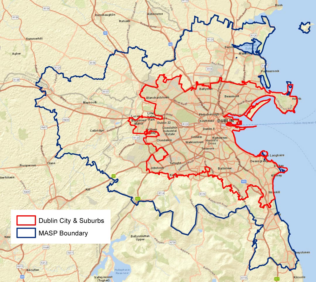
Dublin City and Suburbs
Areas of Fingal categorised as Dublin City and Suburbs with respect to RSES, comprise the majority of Fingal’s urban footprint including Blanchardstown, Clonsilla, Castleknock, Coolmine, Mulhuddart, Ongar, Tyrellstown, Hollystown; to the south the settlements of Santry (including Ballymun) Charlestown and Meakestown as well as the communities of Baldoyle, Sutton, Howth, Balgriffin and Belcamp which lie in proximity to Fingal’s coast.
Blanchardstown and Suburbs
Blanchardstown, strategically located at the intersection of the N3 and M50 national roads, is the largest settlement centre in Fingal, encompassing the important urban neighbourhoods of Clonsilla, Castleknock, Coolmine, Mulhuddart, Ongar, Tyrellstown and Hollystown. Overall, the greater Blanchardstown area is home to approximately 108,000 people as of the 2016 Census.
Blanchardstown is designated as a Level 2 ‘Major Town Centre’ in the Retail Strategy for the Greater Dublin Area and is one of the largest and most important retail centres in the State. In addition to Blanchardstown Town Centre, numerous large public sector employers are based in the area including Fingal County Council, Connolly Hospital and Technological University Dublin (TU Dublin) Blanchardstown. Blanchardstown is a key location for foreign direct investment and major largescale ICT and pharmaceutical companies have long established operations in the area. Blanchardstown is also home to the Dublin Enterprise Zone and to the National Sports Campus, a state-of-the-art sports facility located at Abbottstown.
The Hansfield Strategic Development Zone (SDZ) continues to provide for new sustainable communities served by a new train station on the Clonsilla to M3 Parkway railway spur. Future new sustainable communities within Barnhill and Kellystown will also benefit from direct access to high- capacity rail transport, with significant provision also made for active travel options. Recently adopted Local Area Plans in these areas provide land use frameworks to guide a range of housing, community infrastructure and high-quality recreational opportunities, creating distinctive new communities.
The future development potential of lands at Dunsink, a major greenfield landbank inside the M50 ring is recognised within RSES. This land area, located just six miles from Dublin city centre, comprises approximately 435 hectares, of which approximately 200 will be available for development. The area, located within the M50 cordon, is currently characterised by agricultural and recreational amenity lands and offers significant potential for consolidation in a sustainable manner underpinned by high- capacity public transport given its proximity to Ashtown station and Luas Finglas- the Green Line Extension. A detailed feasibility study of these lands, including examination of current infrastructural constraints is ongoing. In line with regional planning policy, development of a mixed-use district providing approximately 7,000 residential units as a long-term strategic land bank is envisaged.
Charlestown Meakestown, Santry (including Ballymun), Balgriffin and Belcamp
The southern part of the County comprises the existing communities of Charlestown, Meakstown, Santry (including Ballymun) Clonshaugh, Belcamp and Balgriffin. This area lying in close proximity to the administrative boundary with Dublin City Council and has experienced significant growth in recent years, comprising a mix of residential and expanding employment. The communities of Charlestown and Meakstown form important residential settlements to the south of the M50 and the area is well served by retail facilities focussed on the Charlestown Shopping Centre, a Level 3 centre within the Fingal Retail Hierarchy, with schools and community facilities provided close by in Dublin City Council. A Framework Plan is proposed for the Jamestown Industrial Estate to examine future rejuvenation opportunities for the lands, due to their location adjoining regeneration lands in the Dublin City Council area. Future transportation investment including Luas Finglas, Northwood Metrolink stop and BusConnects will benefit ongoing residential and commercial expansion within the area. Transformative change is ongoing to the east at Balgriffin and adjacent the northern extent of Dublin City Council’s operational area, where new residential communities continue to be formed, focused largely on multi-storey, multi-unit schemes benefiting from proximity to DART rail access. Fingal County Council is currently progressing plans through the Part VIII planning consent process for multi-purpose community facilities at Lanesborough. This will provide a new sports hall and community centre at Lanesborough Park in Meakstown, to help cater for a wide-range of community, recreational, education and sporting activities in the area. Lanesborough Park will also be developed.
Strategically, the area benefits from a multitude of employment hubs, including the wider service centres of Blanchardstown, Swords, Finglas, Dublin City and crucially Dublin Airport. Significant employment opportunities exist within long established industrial and business campuses located within both local authority areas, benefiting from access to the M50 and Dublin Belfast strategic corridors. These include Clonshaugh Business Park, Clonshaugh, Airways and Santry Hall Industrial Parks. Given the proximity to Dublin Airport, the area benefits unsurprisingly from the presence of established and evolving specialised aviation related industries, both international and indigenous.
This Plan will pursue objectives to consolidate, enhance and renew the settlements identified ensuring the growth of sustainable communities and strengthening economic performance in order to maximise the competitive advantages arising from the area's geographic location and transport links.
Baldoyle, Sutton and Howth
Baldoyle, Sutton and Howth are long established, historical settlements with distinct character and sense of place which contribute significantly to the character of Fingal. Integral to their character and exceptional amenity offer is their coastal environment including coastal walks, nature reserves, beaches, Racecourse Park, Howth SAAO, Deer Park Castle & Grounds, Irelands Eye, Howth Marina & strong built heritage including the presence of Architectural Conservation Areas in both Baldoyle & Howth Villages as well as excellent public transport accessibility. It is envisaged that these areas will develop through the provision of a range of facilities to support existing and new populations. For this to be achieved, it is vital that the role of Baldoyle, Howth are strengthened, and development consolidated within the original villages. The natural heritage of Baldoyle Estuary & Ireland's eye are areas of international importance, designated through a Special Area of Conservation (SAC) and a Special Protection Area (SPA) and future development must respect the natural heritage sensitivities. Having regard to their proximity to Dublin City, they also comprise consolidation areas within the Metropolitan Area, benefiting from proximity to the DART network and continuing investment in active travel opportunities.
Residential expansion is occurring at Stapolin and LIHAF (now URDF) funding was secured to deliver access to Clongriffin train station and other essential elements including a regional park, attenuation areas and road upgrade works. An increase in the proportion of more compact forms of growth has the potential to make a transformational difference, contributing to the viability of services, shops and public transport, increasing housing supply and enabling more people to live closer to employment and recreational opportunities.
Demand for retail/services is in general, accommodated within Level 4 Small Town and Village Centres/ Local centres within the Retail Hierarchy. Baldoyle has two key employment centres, at Baldoyle Industrial Estate and Kilbarrack Industrial Estate, both providing significant employment for the wider area while Howth continues to demonstrate a wider range of economic functions due to its performance as a high-quality tourist destination and due to its important marine activities. The extension of the Middle Pier to improve access, maintenance, and berthing facilities, due for completion in 2021 will further strengthen and enhance Howth’s maritime industry.
Sutton Cross is the gateway to the Howth Peninsula and an established suburb with a clear identity, community, and a range of urban services such as schools, retail and community facilities. It supports local services for the immediate populations of Howth, Sutton, Baldoyle and Bayside.
Howth is afforded a high degree of protection because of SAAO and European Site designations while Sutton is also located in proximity to these designations. Significant investment has been carried out in relation to the Howth Head looped trails including improved surfacing, seating and way finding. Racecourse Park Baldoyle will be transformed to include walking and cycling routes, lighting, car parking, playgrounds as well as sporting and recreational facilities. The Baldoyle Portmarnock Greenway, part of the longer-term Sutton to Malahide Greenway, ultimately linking to the permitted Broadmeadow Greenway and the Sutton to Sandycove cycleway is and will continue to bring significant active travel and recreational opportunities to these areas.
Policies and Objectives: Dublin City and Suburbs
|
Policy CSP19 Compact, Sequential and Sustainable Urban Growth Promote compact, sequential and sustainable urban growth to realise targets of at least 50% of all new homes to be built, within or contiguous to the existing built-up area of Dublin city and suburbs and a target of at least 30% for other metropolitan settlements, with a focus on healthy placemaking and improved quality of life. Policy CSP20 Blanchardstown Consolidate the growth of Blanchardstown as set out in the Settlement Strategy for RSES by encouraging infill development and compact growth rather than greenfield development and by intensification at appropriately identified locations. Policy CSP21 Santry, Ballymun and Meakstown, Charlestown, Finglas and Lanesborough Define the areas of Santry, Ballymun and Meakstown, Charlestown, Finglas and Lanesborough positively by the development and enhancement of greater connectivity links between these areas and the rest of Fingal. Policy CSP22 Howth, Sutton and Baldoyle Consolidate the development and protect the unique identity of Howth, Sutton and Baldoyle. This includes protection against overdevelopment. Policy CSP23 Howth SAAO Protect the Howth Special Amenity Area Orders (SAAO), including the Buffer zone, from residential and industrial development intended to meet urban generated demand. Policy CSP24 Liffey Valley SAAO Protect the Liffey Valley Special Amenity Area Orders (SAAO), including the Buffer zone, from residential and industrial development intended to meet urban generated demand. |
|
Objective CSO19 Promotion of Higher Densities Promote higher densities (50+ units per hectare) at appropriate locations in urban built up areas subject to meeting qualitative standards at appropriate locations with particular reference to urban centres and/or in proximity to high-capacity public transport nodes while demonstrating compliance with all relevant Section 28 Ministerial Guidelines. |
|
Objective CSO20 Sensitive Redevelopment of Key Sites Encourage the sensitive redevelopment of key sites within the Dublin City and Suburbs area for mixed use which includes an appropriate residential component to enhance the viability and vitality of existing urban villages. Objective CSO21 Town Centre Regeneration Continue to develop a strategic approach to town centre regeneration through the ‘Town Centre First’ Approach within settlements forming part of the Dublin City and Suburbs Area by utilising existing buildings and unused lands for new development, promoting residential occupancy and providing a mix of uses within these areas, including cultural and community uses and residential uses, as appropriate. Objective CSO22 Blanchardstown Town Centre & DEZ Promote Blanchardstown Town Centre as an integral component in the promotion and development of the Dublin Enterprise Zone. Objective CSO23 Optimising Existing Local Heritage Resources and Public Amenities Require that new development in the urban settlements of the Dublin City and Suburbs area optimises existing local heritage resources and public amenities, while protecting the character and biodiversity of the villages. Objective CSO24 High Quality, Sustainable & Inclusive Development Promote development which incorporates a high quality, sustainable and inclusive approach to proposals in the Dublin City and Suburbs Area, which are supported by sustainable means of travel and which create locally distinctive neighbourhoods and positively contribute to the existing built and natural heritage. Objective CSO25 Promote and Enhance existing ACA’s Continue to promote and enhance the existing ACA’s within our urban villages and protect their historic characters. Objective CSO26 Improved Sense of Identity Develop enhanced community identities throughout Fingal through the improvement of social, cultural, community and residential amenities. Support the development of an improved sense of identity for the areas within Dublin City and Suburbs, including improvements to signage, landscaping and physical appearance and through the promotion of mixed uses, including residential, in our urban villages. |
|
Objective CSO27 LAP’s, Masterplans & Frameworks Plans for Dublin City and Suburbs As set out in Tables 2.15, 2.16, 2.17, 2.18 and 2.19
Objective CSO28 Intensive Population & Employment Uses The Plan will promote more intensive population and employment uses focussing on good community, civic and school facilities, good quality streets and spaces whereby existing and new neighbourhoods are knitted together alongside essential infrastructure and amenities that are required to develop sustainable communities and employment within the key urban centres, consistent with RPO 4.3. Objective CSO29 Dunsink Prepare a local statutory plan for lands at Dunsink in consultation with the relevant stakeholders, including an infrastructural audit with costings and implementation strategy to enable sustainable regeneration and development of the area over the medium to long term. Objective CSO30 Belcamp Consider a limited quantum of development on the Belcamp lands to facilitate the rehabilitation and preservation of Belcamp House. A design brief including the quantum and location of any such development, which shall not prejudice any future road requirements, shall be agreed with the Planning Authority prior to a planning application being lodged. Not more than 50% of any residential units permitted shall be sold or occupied pending the full re-instatement of Belcamp House to the satisfaction of the Planning Authority. Objective CSO31 Ongar Enhance and promote all existing greenspaces in Ongar by providing sensitive and appropriate leisure infrastructure within the boundary of the greenspace. Objective CSO32 Feasibility Study – Howth Tram/Funiculars Carry out a feasibility study to examine the potential for the reinstatement of a tram or funiculars from Howth DART station to Howth Summit. |
Key Town Swords
Swords is identified as one of three Key Towns in RSES within the Metropolitan area, the remaining two being Bray and Maynooth. Key towns are defined as large economically active service and/or county towns which provide employment for surrounding areas. Such centres also benefit from high- quality transport links and have the capacity to act as growth drivers to complement Regional Growth Centres. Key Towns, given their historic significance and performance as settlements within a regional context, have potential to accommodate commensurate levels of population and employment growth, facilitated by their location on high quality public transport corridors and aligned with requisite investment in services, amenities and sustainable transport.
Swords is the administrative capital of Fingal County Council with a population of 44,446 within the development boundary, as per the 2016 Census. Due to its strategic location, with direct links to the national road network (M1, M50 and Dublin Tunnel) as well as proximity to the Dublin/Belfast economic corridor, Swords plays a vital role in the overall MASP strategy, fulfilling key residential and employment functions. Swords is home to some of the largest employers in the country, including highly skilled employment centres arising through links with Dublin Airport. The important relationship between Swords and Dublin Airport is recognised in the Plan and the protection and enhancement of airport access as a global gateway to the Region and the State will be protected.
Residential development in Swords continues within establishing areas to the west and south of the town including Oldtown-Mooretown and Ridgewood with the longer-term residential potential of the town focused on the strategic land bank of Lissenhall to the east. It is envisaged that this important reserve could accommodate a significant mixed-use employment district in addition to providing between 6,000 and 7,000 residential units. Swords Masterplans (Barryspark, Crowcastle, Fosterstown and Estuary West) while providing a framework for the delivery of employment and opportunities for commercial floorspace, also offer the potential for medium/long term residential development into the future.
The delivery of Metrolink in co-ordination with other transport proposals, including BusConnects, future Park & Ride facilities and enhanced electric vehicle charging infrastructure, are all crucial for the future sustainable development of Swords. Active travel options such as the Broadmeadow Greenway and Fingal Coastal Way also offer significant opportunities for further sustainable travel options which will benefit the town and significantly enhance connectivity with neighbouring settlements and the adjoining hinterland.
A significant proportion of future urban development within Key Towns should be accommodated on infill/brownfield sites by encouraging development, including renewal and regeneration of underused, vacant or derelict town centre lands for residential development to facilitate population growth. RSES identifies the importance of rejuvenating Main St. Swords which will unlock opportunities for promoting compact growth, realising infill development and bring about public realm improvements. The Sustainable Swords Project, a flagship initiative to enhance connectivity and provide significant public realm improvements, encompassing the Swords Cultural Quarter, is key to achieving a co-ordinated healthy placemaking strategy for the town, focusing on its key historical attributes and potential.
Swords Key Town
|
Policy CSP25 Consolidation and Growth of Swords Promote and facilitate the long-term consolidation and growth of Swords as a Key Town including the provision of key enabling public transport infrastructure, including MetroLink, in accordance with the relevant provisions of the NPF, RSES and the MASP. Policy CSP26 Key Sites for Regeneration Support objectives to achieve a minimum of 30% of housing in the Key Town of Swords by way of compact growth through the identification of key sites for regeneration. |
|
Policy CSP27 Swords as an Economic Driver Promote Swords as an economic driver and provide for strategic employment locations to improve its economic base and increase the ratio of jobs to workers. Policy CSP28 Promote and Facilitate Metrolink Promote and facilitate the development of Metrolink, connecting Swords to the Airport and on to the City Centre. Policy CSP29 Swords as a Vibrant Key Town Support the continued development of Swords as a vibrant Key Town with a thriving economy; an integrated public transport network; an attractive and highly accessible built environment with the highest standards of housing, employment, services, recreational amenities and community facilities. |
Key Town Objectives
|
Objective CSO33 High Quality Services Encourage a range and quality of retail, commercial, civic, cultural, leisure, community and other services commensurate with the role of Swords Town Centre as a Key Town. Objective CSO34 Swords Main Street Retain the Main Street as the core of the town centre, protect and enhance its character and ensure that any future new commercial and retail development reinforces its role by promoting the development of active ground floor uses and limiting the expansion of certain non-retail and inactive street frontages including financial institutions, betting offices, public houses and take aways/fast food outlets. Objective CSO35 Sustainable Swords Project Support and promote the implementation of key recommendations arising from the Sustainable Swords’ project including the implementation of the Swords Cultural Quarter. Objective CSO36 Public Engagement & Sustainable Swords Support new forms of public engagement in the preparation of the Sustainable Swords project, with a view to building strong public interest, understanding and buy-in for the recommendations of the project. Objective CSO37 Regeneration and Infill Opportunities Support the regeneration of underused town centre lands along with the planned and sequential infill opportunities to provide for high density and people intensive uses in accessible locations that are accessible to high quality transport, existing and planned, and to support the preparation of a statutory land use plan for the strategic landbank at Lissenhall for the longer-term development of Swords. Objective CSO37 Regeneration and Infill Opportunities Support the regeneration of underused town centre lands along with the planned and sequential infill opportunities to provide for high density and people intensive uses in accessible locations that are accessible to high quality transport, existing and planned, and to support the preparation of a statutory land use plan for the strategic landbank at Lissenhall for the longer-term development of Swords. Objective CSO38 Enhanced Urban Environment Facilitate the strategic regeneration of Swords to build on the resilience of the local economy and provide for an enhanced urban environment with a particular focus on the development of Swords Civic Centre and Cultural Centre, the delivery of the conservation plan for Swords Castle, and the delivery of an enhanced public realm in the town centre and to promote recreational and amenity uses in accordance with a healthy placemaking strategy. Objective CSO39 Swords – Dublin Airport Support Swords-Dublin Airport as a key location for airport related economic development and employment provision linked to the protection and enhancement of access to Dublin Airport lands including the delivery of Metrolink. Objective CSO40 LAP’s, Masterplans and Framework Plan for Swords As set out in Tables 2.15, 2.16, 2.17, 2.18 and 2.19:
|
Self -Sustaining Growth Towns
Self-Sustaining Growth Towns are defined in RSES as towns which contain a reasonable level of jobs and services which adequately caters for the people of its service catchment. This may include sub- county market towns and commuter towns with good transport links, which have capacity for continued commensurate growth. Such towns offer potential for increased residential densities at high quality public transport hubs and can accommodate average or above average growth to provide for natural increase, service and/or employment growth where appropriate.
Donabate is identified as a Self-Sustaining Growth Town within Fingal and is strategically located, benefiting from its position on the North-South Strategic Corridor. DART expansion, which is to be delivered by 2027, will increase capacity on the northern commuter line and will further support and strengthen connectivity. The settlement has experienced substantial housing development in recent years and extensive areas of undeveloped residential zoned land remains to the east and south of the town. Development will be carried out in accordance with the principles enshrined in the Donabate Local Area Plan 2016-2022 (extended to 2026). The development strategy will promote the creation of a vibrant town core by providing a high-quality living environment for existing and future populations and provide all necessary community, commercial, cultural, and social facilities in tandem with new residential development.
The town benefits from its proximity to recreational resources of Newbridge Demesne, and plans are proposed for a major new Recreational Hub at Ballymastone which will complement existing sporting facilities within and to the east of the town. The Development Plan will also support the preparation and implementation of a Public Realm Framework for Donabate with particular focus on the Main Street, entrances to the town and key realm enhancement opportunities. The Donabate Peninsula enjoys many natural areas including the Rogerstown and Malahide Estuaries, European Sites which form part of the Natura 2000 network.
Self-Sustaining Growth Towns Policies
|
Policy CSP30 MASP Strategic Development Areas Deliver strategic development areas identified in the MASP, located at key nodes along high-quality public transport corridors in tandem with the delivery of infrastructure and enabling services to ensure a steady supply of serviced sites and to support accelerated delivery of housing. Policy CSP31 Donabate LAP Facilitate development on zoned residential lands within the settlement boundary of Donabate as prescribed in the Donabate LAP. Support the provision of the necessary social and community infrastructure including recreational facilities and strengthen and enhance the public realm, providing improved levels of connectivity and permeability. Policy CSP32 Consolidate Development and Protect Unique Identity of Donabate Consolidate the development and protect the unique identity of Donabate. |
Self-Sustaining Growth Towns Objectives
|
Objective CSO41 LAP’s and Framework Plans for Donabate
Objective CSO42 Donabate Town Centre Channel and concentrate the development of additional commercial, social, community and civic facilities within Donabate town centre and promote high quality urban design in such development. Objective CSO43 Donabate Peninsula Develop a continuous network of signed pathways and cycleways as appropriate, around Donabate Peninsula linking Portrane and Donabate to Malahide and Rush via the Rogerstown and Malahide Estuaries whilst ensuring the protection of designated sites and avoiding any routing along the northern boundary of Malahide Inner Estuary by virtue of its ecological sensitivity. Objective CSO44 Pedestrian and Cycleways in Donabate Provide for a comprehensive network of pedestrian and cycle ways linking residential areas to one another, to the town centre, schools, the recreational campus at Ballymastone and the railway station. Objective CSO45 Croballis/Balcarrick - Sewage Mains Connections Promote and support the provision of a sewage mains connections for Corballis/Balcarrick residents. Objective CSO46 Active Travel Connections Between Donabate-Rogerstown Park and Lusk-Rush. Investigate all options in looking at the delivery of active travel connections between Donabate-Rogerstown Park and Lusk-Rush. |
Self-Sustaining Towns
Self-Sustaining Towns are towns that require contained growth, focusing on driving investment in services, employment growth and infrastructure whilst balancing housing delivery. RSES envisages that population growth in these towns shall be at a rate that seeks to achieve a balancing effect and shall be focused on consolidation and inclusion of policies in relation to improvements in services and employment provision.
Self-Sustaining Towns within Fingal are located in both the Metropolitan and Core Areas and comprise, Malahide, Portmarnock, Balbriggan, Rush, Lusk and Skerries.
Malahide
Malahide is designated a Self-Sustaining Town within the RSES and benefits from a high quality built and natural environment. Integral to its character and its exceptional amenity offer is Malahide Castle and Demesne, its coastal environment, tourism offer, its strong built heritage including the presence of Architectural Conservation Areas as well as excellent public transport accessibility. It is envisaged that Malahide will develop as a self- sustaining centre through the provision of a range of facilities to support existing and new populations. For this to be achieved, it is vital that the urban role of Malahide is strengthened, and development consolidated within the town. The natural heritage of Malahide Estuary, a European Site, is designated through a Special Area of Conservation (SAC) and a Special Protection Area (SPA) and future development must respect the natural heritage sensitivities.
The settlement contains a strong village centre structure with a regional park and access to a high level of local amenities. Housing delivery is being provided at a steady pace.
Portmarnock
A further important settlement located on the strategic rail network is Portmarnock. Portmarnock is a historic coastal settlement which developed in its linear suburban form in the 20th century. Further definition of the street frontage and upgrading of the streetscape would help to strengthen and consolidate the existing urban structure and identity of Portmarnock. Its location just north of Baldoyle Estuary, a Special Area of Conservation (SAC) and a Special Protection Area (SPA), the presence of one of the finest beaches on the east coast, world class golf courses and a distinct natural and building heritage make Portmarnock an important tourist destination. There is potential to sensitively enhance the tourist experience through appropriate development of tourist services and amenities. The settlement through its own unique identity and character may be classed as a consolidation area within the metropolitan area, similar to Baldoyle, Sutton and Howth, given its location in proximity to Dublin City, coupled with key transport links. Development policy in relation to such consolidation towns will be based largely on their ability to meet locally generated demand for retail and services and on future growth related primarily to higher densities along public transport corridors. Residential development continues to be provided on lands to the southwest of Portmarnock as part of the Portmarnock South LAP and significant improvements will continue to be made in the provision of active travel options building on the success of the Baldoyle Portmarnock Greenway, a vital phase in the Sutton to Malahide Greenway. Portmarnock’s commercial core and retail/service offer continues to grow, particularly along Strand Road with opportunity to provide for further commercial consolidation.
Balbriggan
Balbriggan is the largest of the Self-Sustaining Towns in the Core Area. Located c.18 kms north of Swords, with easy access off the M1 Motorway, it is also served by the main Dublin to Belfast rail line and commuter services to Dublin City. It has developed as a major residential town with a young and expanding population of 20,000 which has more than doubled over the past 20 years. Major infrastructural projects involving upgrades to the water supply, foul drainage and roads infrastructure have been carried out throughout the town and its environs. Balbriggan is eFibre broadband enabled with superfast fibre delivering speeds of up to 100Mb. Fingal County Council has prepared and is implementing ‘Our Balbriggan 2019-23 Rejuvenation Plan’, which will transform Balbriggan Main Street and Harbour and will provide significant investment in the public realm and town centre improvements to provide a more vibrant and vital centre to the town. This will be achieved in continued collaboration with stakeholders, by increasing employment, promoting industrial lands and by showcasing Balbriggan as an attractive location for investment.
The availability of zoned lands for high technology and general industrial development, together with the significant infrastructural and environmental improvements with easy access to major transport corridors, ports, rail and air networks, offer considerable potential for the town. Fingal County Council is committed to working with representative stakeholders such as the IDA, Enterprise Ireland and the local Chamber of Commerce, to attract and facilitate new employment generators into the town.
Rush
Rush has a distinctive and unique physical character and history and has been identified as a Self- Sustaining Town in accordance with the RSES definitions. Rush is a linear town focused on its long Main Street with a significant tradition of market gardening in and around the town. In recent times, the trend is towards the relocation of these horticultural operations to the rural area, west of the town and the development of new residential communities. The development strategy is to expand the town centre as a commercial, retail, employment and services centre serving the expanding community in line with Rush’s designation as a Self-Sustaining Town. The strategy includes opportunities for local rural business and general industry employment. In this regard, lands are zoned for the development of market gardening/rural business and more general employment/business development to the west of the town. Proposed new road systems together with existing roads form part of the overall strategy. This supports the preservation of the towns distinct character, retention of its market gardening tradition, the protection and enhancement of amenities and promotion as a local tourist destination. Retail provision in Rush should be self-sustaining in line with its role as a Self-Sustaining Town in the RSES. To avoid the creation of unsustainable commuting patterns, retail development should be at a level to serve the needs of the existing settlement and its rural hinterland but not attract inward commuting from adjacent towns.
Lusk
Lusk, also identified as a Self-Sustaining Town has grown in recent years from a village to a small town. Lusk is an historic settlement with notable built heritage and a distinctive character with a wealth of archaeology, traditional vernacular buildings and a distinct medieval street pattern around the town core which is a designated ACA. Rogerstown Estuary located to the south of the town is a European Site which must be protected into the future. It is important to conserve and enhance the unique character of the town core, consolidate the planned growth and ensure that the level of retail and local services concentrated in and adjacent to the town core grows to serve the expanding town population. To avoid the creation of unsustainable commuting patterns, retail development should be at a level to serve the needs of the existing settlement and its rural hinterland but not attract inward commuting from adjacent towns. Existing and future development will be consolidated within well- defined town boundaries and the distinct physical separation of Rush and Lusk will be maintained.
Skerries
Skerries is a compact coastal town served by a railway station. Benefiting from a well-defined town centre and access to coastal amenities and a regional park, it is considered that future residential development would be managed through a master-planning process. The development strategy reflects its status as a self-sustaining town, and the need to protect the character of the historic core, to consolidate development within well-defined boundaries and provide retail at an appropriate level for the town's needs.
Self-Sustaining Towns Policies
|
Policy CSP33 Consolidate Growth of Self-Sustaining Towns Consolidate the growth of Self-Sustaining Towns including Malahide, Portmarnock, Balbriggan, Lusk, Rush and Skerries as set out in the Settlement Strategy for RSES and by encouraging infill development and compact growth rather than greenfield development and by intensification at appropriately identified locations. Policy CSP34 Malahide Promote the planned and sustainable consolidation of the existing urban form and protect the unique identity of Malahide. The need to upgrade and support the development of the town centre will be balanced with the need to conserve its appearance as an attractive, historic village settlement and to retain the existing amenities of the area, being cognisant of its proximity to the ecologically sensitive coastline including European Sites. Policy CSP35 Focus Growth Within and Contiguous to Core in Self-Sustaining Towns Support the sustainable long-term growth Self-Sustaining Towns by focusing growth within and contiguous to the core to create a critical mass of population and employment based on local demand and the ability of local services to cater for sustainable growth levels. |
|
Policy CSP36 Promotion of Enterprise and Employment in Self-Sustaining Towns Promote enterprise and employment throughout the County including along the Dublin Belfast Economic Corridor including Balbriggan and work with other Local Authorities to promote Fingal and the wider mid-eastern region as an engine for economic growth. Policy CSP37 Malahide, Portmarnock, Balbriggan, Lusk, Rush and Skerries Consolidate development and protect the unique identities of the settlements of Malahide, Portmarnock, Balbriggan, Lusk, Rush and Skerries. |
Self-Sustaining Towns Objectives
|
Objective CSO47 Support Growth of Self-Sustaining Towns Proactively support and promote high quality services, social infrastructure, facilities, tourism offer, appropriate retail mix, and economic activity within Self-Sustaining Towns to meet the needs of existing and future growth in line with the scale and function of these towns within the Fingal Settlement Hierarchy Objective CSO48 Safe and Convenient Road, Pedestrian and Cycle Systems Ensure all Self-Sustaining towns benefit from safe and convenient road, pedestrian and cycle systems which promote permeability, accessibility, and connectivity between existing and new developments. Objective CSO49 LAP’s, Masterplans and Framework Plans for Self-Sustaining Towns As set out in Tables 2.15, 2.16, 2.17, 2.18 and 2.19:
Objective CSO50 Tree-Lined Approach Retain existing tree-lined approaches to all towns and villages in order to preserve their special character. Objective CSO51 Development and Growth of Balbriggan and Skerries Promote and facilitate the development and growth of Balbriggan and Skerries as primary service, social, cultural and local tourist centre in north Fingal. Objective CSO52 ‘Our Balbriggan’ Continue to implement, promote, and support the ‘Our Balbriggan’ Rejuvenation Plan |
|
Objective CSO53 Harbours, Beaches Seashores – Balbriggan, Skerries and Rush Preserve and improve access to the harbours, beaches and seashores of Balbriggan, Skerries and Rush, while protecting environmental resources including water, biodiversity, and landscape sensitivities. Objective CSO54 Rush as a Vibrant Town Facilitate the development of Rush as a vibrant town and retain its market gardening tradition. Objective CSO55 Historic Core of Lusk Protect and conserve the special character of the historic core of Lusk including the area of archaeological notification in the centre of the town having regard to the physical and social character of the core area particularly in the vicinity of St. MacCullin’s Church and Main Street, and to promote a conservation-led approach to the consolidation and redevelopment of the town core. Objective CSO56 Monastic Site and St. MacCullins Church Maintain the valued distinctive views of the monastic site and St. MacCullin's Church from all approach roads into Lusk, from significant areas of open space and from surrounding areas. Objective CSO57 Hedgerows in Lusk Retain the traditional hedgerow boundary treatment characteristic of Lusk, the protection and enhancement of existing boundary hedgerows and trees shall be required save where limited removal is necessary for the provision of access and promote the planting of hedgerows and trees using native species within new developments. Objective CSO58 Maintenance of Distinct Physical Separation – Lusk, Rush and Malahide Ensure that existing and future development within the settlements of Lusk, Rush and Malahide is consolidated within well-defined town boundaries to maintain their distinct physical separation. Objective CSO59 Pedestrianised Core – Malahide Continue to promote and facilitate the recently implemented pedestrianised core of New Street, Malahide. Objective CSO60 Sluice River – Portmarnock Protect and manage the flood plain of the Sluice River to the south of Portmarnock and ensure that its integrity as a natural habitat is maintained; and investigate the potential of a riverside walkway. Objective CSO61 Assessment to Inform Future Transportation Needs of Rush Carry out an assessment to inform the future transportation needs of Rush. This may include the feasibility of providing a Distributor Road to the west of Rush. |
Towns and Villages
Fingal contains a significant number of towns and villages within the Metropolitan and Core areas of the County. These include: Portrane, Coolquay, Kinsealy, Rivermeade, Rowlestow,n Balrothery, Loughshinny, Ballyboghil, Naul, Balscadden, Oldtown, Garristown, and Ballymadun.
There is considerable variation across the settlements in this level of the Hierarchy, ranging from small towns and larger rural villages, in terms of scale, character, context and infrastructure. However, all have potential for appropriate levels of growth and consolidation. In order to realise consolidation within these towns and villages, development will be encouraged to be delivered in a sustainable, sequential manner, with the focus on consolidated growth of the centres, the identification of sites appropriate for renewal and a focus on enhancement of town centre public realms.
Many act as important local drivers, providing a range of functions for their resident population and their surrounding catchments including housing, employment, services and retail and leisure opportunities. A Town Centre First approach will be adopted in the Plan to increase levels of economic activity and overall vibrancy levels. A number of these settlements have experienced varying levels of commuter focused residential expansion and require consolidation and targeted ‘catch up’ investment in services, infrastructure, suitable transport options, amenities and local employment, whilst balancing housing delivery and focusing on consolidation to become more sustaining.
Development in these centres is to be managed in line with the ability of local services and infrastructure to accommodate expansion, having regard to the recommendations for small towns included in the Ministerial Guidelines on Sustainable Residential Development in Urban Areas and RSES.
Residentially zoned lands at Baskin, west of Kinsaley village and south of Abbeville ACA comprise single residential units accessed off Baskin Lane and consolidated residential development clustered around the original Baskin cottages settlement which has grown organically over the years with development fronting onto Baskin Lane and on lands to the rear of the existing cottages.
Towns and Villages Policies
|
Policy CSP38 Promote sustainable expansion and development at a level appropriate to and integrated with the existing town or village, meeting the socio-economic and civic aspirations of the community, whilst preserving the settlements distinctive character, heritage, amenity and local identity. |
Towns and Villages Objectives
|
Objective CSO62 LAP’s, Masterplans and Framework Plans for Towns and Villages As set out in Tables 2.15, 2.16, 2.17, 2.18 and 2.19:
Objective CSO63 Rural Villages Manage the development of Rural Villages within the RV boundaries and strengthen and consolidate their built form providing a suitable range of housing as an alternative to housing in the open countryside. Objective CSO64 Scale of New Housing Developments in Towns and Villages Ensure that the scale of new housing developments within Towns and Villages both individually and cumulatively, shall generally be in proportion to the pattern and grain of existing development Objective CSO65 Historic Towns and Village Centres Protect and enhance the unique physical character of historic town and village centres. Objective CSO66 Commerical and Community Facilities Facilitate and encourage improved town and village facilities both commercial and community to meet the needs of expanding towns and villages. Objective CSO67 Compact, Organic and Sequential Development of Towns and Villages The scale of new residential schemes within Towns and Villages shall be in proportion to the pattern and grain of existing development with a focus on delivering compact growth and providing for the organic and sequential development of the settlement. Infill and brownfield development shall have regard to the existing town or village character and create or strengthen a sense of identity and distinctiveness for the settlement. |
|
Objective CSO68 Commerical Development in Towns and Villages New commercial development in Towns and Villages shall generally only be located within the core area and shall contribute positively to character of the settlement. |
St. Ita’s
The existing institutional complex is very extensive and accommodates a large number of protected structures and attractive buildings in an extensive demesne type landscape. Building elements within the complex are landmark structures, which are visible over long distances from the coastline particularly to the south. There are exceptional coastal views from this slightly elevated site.
The need to examine options regarding the optimal re-use and refurbishment of the complex of Protected Structures within the demesne setting was identified by the Council, to ensure the future sustainable use of this important and unique resource. A feasibility study of St Ita’s, was completed in November 2013 jointly by Fingal County Council and the Health Service Executive (HSE) to determine the optimal future sustainable use of this complex and to consider the development of new modern psychiatric health care and ancillary facilities having regard to the cultural, visual and ecological sensitivities of the site.
The Feasibility Study identified the St Ita’s Hospital complex and demesne as a suitable location for the development of new modern psychiatric health care and ancillary facilities, which includes the provision of a National Forensic Mental Health Service Hospital. It also prioritizes the re-use of the existing hospital buildings (many of which are Protected Structures) together with their maintenance and management into the future; the ongoing maintenance and management of existing trees and woodland and the maintenance and provision for an appropriate level of public accessibility through the site.
It is the objective of Fingal County Council to actively support the implementation of the objectives laid down in this feasibility study including specifically those relating to:
- The ongoing development of modern psychiatric health care and ancillary facilities, which includes the provision of a National Forensic Mental Health Service Hospital within St. Ita’s.
- The reuse of the Protected Structures for appropriate uses together with the on-going future maintenance and management of these structures.
- The on-going maintenance and management of the demesne landscape including the trees and woodland which are an intrinsic part of this unique landscape.
- The maintenance and provision for an appropriate level of public accessibility through the site.
|
Objective CSO69 Feasibility Study for St. Ita’s Hospital Lands Actively support the implementation of the objectives laid down in the Feasibility Study for St. Ita’s Hospital Lands completed in November 2013, including specifically those relating to:
|
|
Objective CSO70 Protected Structures at St. Ita’s Hospital Complex and Demesne Promote the use or reuse of all the Protected Structures at St. Ita’s Hospital complex and demesne in Portrane as a priority for Fingal County Council. Notwithstanding the use class ‘HA’ Zoning matrix, appropriate uses within the Protected Structures and within the ancillary land areas within the complex including uses which also relate to and are consistent with the historic use of the overall historic complex (established prior to the foundation of the Irish State) will be actively promoted and allowed to proceed subject to appropriate consent where such activities will secure viable sustainable re use of the complex into the future and which will provide for the proper conservation and sustainable development of St. Ita’s. |
Rural Towns and Villages
Fingal benefits from a rich agricultural hinterland interspersed with distinctive towns and villages. These settlements have unique characteristics many historic qualities underpinned by a keen sense of place and benefitting from active communities. The NPF identifies the need to strengthen and diversify rural towns to become a focus for local housing and employment growth, recognising their important role in providing social and economic functions. Whilst acknowledging population growth within Fingal’s Rural Towns and Villages in line with regional planning policy (Metropolitan and Core areas) it will be important to ensure the scale of such growth is commensurate with the scale of the settlement a holistic approach is taken in pursuing consolidation, enhanced sustainability, inclusivity and resilience.
The Plan is committed to ensuring Fingal’s rural towns and villages develop in a sustainable way. This will primarily be achieved through the orderly development of identified rural villages and clusters, recognising the distinction between villages in the Metropolitan Area and those in the rural Core Area.
Rural Towns and Villages Policies
|
Policy CSP39 Sustainable Rural Development Support sustainable rural development and strengthen rural networks, economies and communities while managing urban generated growth. Policy CSP40 Review of Rural Housing Policy Commence a review of the Rural Housing Policy and Local Need Criteria on the publication by Government of updated Guidelines for Planning Authorities on Sustainable Rural Housing. Policy CSP41 Viable Options for the Rural Community Provide viable options for the rural community through the promotion of appropriate sustainable growth of Fingal’s rural villages and towns. Policy CSP42 Greenbelts Strengthen greenbelt lands by identifying opportunities for infill development and consolidation of existing towns and villages to reduce the need to zone additional greenfield lands and ensure the preservation of strategic greenbelts to avoid coalescence of settlements. Support development within the Greenbelts which has a demonstrated need for such a location, and which protects and promotes its permanency. |
Rural Towns and Villages Objectives
|
Objective CSO71 Rural Generated Housing Direct rural generated housing demand to Villages and Rural Clusters in the first instance and to ensure that individual houses in the open countryside are only permitted where the applicant can demonstrate compliance with the criteria for rural housing set down in Chapter 3 Sustainable Placemaking and Quality Homes and in Chapter 14 Development Management Standards. Objective CSO72 Re-Use and Rehabilitation of Existing Housing Stock Encourage re-use and rehabilitation of existing housing stock in rural areas in preference to new- build and actively promote the protection of traditional rural buildings. Objective CSO73 Promotion of Attractive and Vibrant Villages Promote attractive and vibrant villages ensuring their sustainable expansion and development at a level appropriate to and integrated with the existing village while meeting the socio-economic and civic aspirations of the community and affording maximum environmental protection. Objective CSO74 LAP’s and Masterplans for Rural Towns and Villages As set out in Tables 2.15, 2.16, 2.17 and 2.18:
|
Rural Clusters and Rural Area
Noting that rural areas within Fingal are categorised as being under strong urban influence, a key challenge is to ensure a balance between facilitating those with a genuine need to reside in rural Fingal while managing urban generated demand. Fingal’s Rural Housing Policy is based on requirements for a demonstrable economic or social need to live in a rural area and ensure that siting and design adhere to statutory guidelines and design criteria. This approach follows on from the Rural Housing Guidelines (2005).
Rural Clusters and Rural Area Policies
|
Policy CSP43 Rural Housing In line with RPO 4.80, manage urban generated growth in Rural Areas Under Strong Urban Influence by ensuring that in these areas the provision of single houses in the open countryside is based on the core consideration of demonstrable economic or social need to live in a rural area, and compliance with statutory Guidelines and plans, having regard to the viability of smaller towns and rural settlements. |
|
Policy CSP44 Rural Settlement Strategy Respond to rural-generated housing need by means of a rural settlement strategy which directs the demand where possible to Rural Villages and Rural Clusters and permit housing development in the countryside only for those people who have a genuine housing need in accordance with the Council’s Rural Housing Policy and where sustainable drainage solutions are feasible. Policy CSP45 Rural Clusters Promote appropriate sustainable growth of the Rural Clusters balanced with carefully controlled residential development in the countryside. |
Rural- Clusters and Rural Area Objectives
|
Objective CSO75 Rural Settlement Strategy Implement the Rural Settlement Strategy contained in Chapter 3 Sustainable Placemaking and Quality Homes and associated Development Management Standards set out in Chapter 14. |
- [1] ESRI calculations for unmet need 2017 to 2023Q1 minus the taskforce completions) plus the present number of homeless families). 3672+401= 4,073.
Clár ábhair
Ábhair
Tráchtanna
Tráchtanna
Revise 1999 rule
Logically, 15 years after 1999 it would be possible for a family member to have established close family ties of their own, and so, in the interests of fairness and equality, this rule should have...